DOWNLOAD MY NEW FREE JOESTRADAMUS WEATHER APP FOR ANDROID
THE APP IS ABSOLUTELY FREE TO ALL BUT CONSIDERING SUBSCRIBING TO PATREON FOR A WEATHER EXPERIENCE FREE OF ADS, EXCLUSIVE VIDEOS FOR MEMBERS ONLY AND MUCH MORE…STARTS AT $2 A MONTH..MESSAGE ME AT ANY TIME
Rain Wind Storm Late Week White Christmas Chances
The weekend storm which brought miserable weather here is now cranking away in the Canadian Maritime Provinces and this is creating gusty winds and bringing down cold air for tonight into Wednesday morning. This is the coldest it will be all week because that cold air pulls out and there won’t be any cold air around as the next storm system takes shape for the Eastern US late in the week.
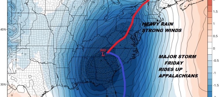
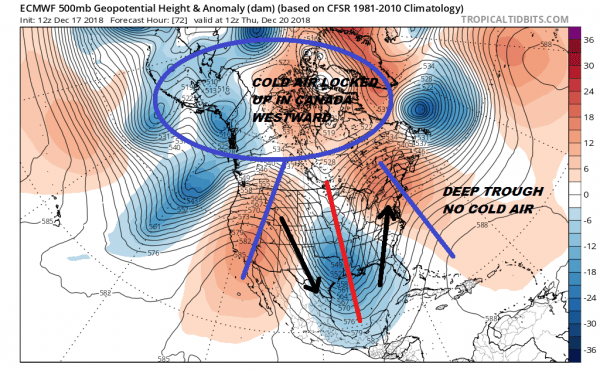
This is different from what we just experienced. No phase occurred with the northern & southern jets with the weekend storm so there was no cold air for us though it made it in time for Northern New England. This time we have the opposite. We have a full phase of the northern & southern parts of the jet stream but the trough is so far to the west that we wind up with a surface low riding up the Appalachians and strengthening. In addition the overall pattern keeps cold air locked up in Central & Western Canada westward with no connection to bring that cold air into the Eastern US.
This is going to be a heavy rain and strong wind producer with southerly gales and heavy rain likely for Friday and lasting into early Saturday though it would be more showery in nature Friday night & Saturday. Temperatures will be in the 50s and rainfall amounts could be up to a couple of inches.
WHITE CHRISTMAS CHANCES
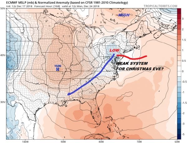
Once this storm passes we have a slight shot of colder air behind it for Sunday and Monday.The European model which for now continues to stand alone in this idea brings a weak system rapidly eastward into the Ohio Valley and into Central Pennsylvania which will likely then redevelop offshore and move eastward.
Every other model out there has a much weaker system with a flat flow where you can barely even find it in the flow. The other models suggest seasonally cold and dry through Christmas Day. The European model leaves the door open slightly for the possibility of a coating to a couple of inches of snow in some areas (depending on track). A little further north and this becomes a non event here with just perhaps the chance for a passing rain or snow shower. The slightly negative nature of the North Atlantic Oscillation favors a track further south and a colder look but the weak nature of the pattern next week means this would be nothing major. The European has been showing this idea since the weekend so we will leave the idea of a White Christmas on the table for now.
MANY THANKS TO TROPICAL TIDBITS FOR THE USE OF MAPS
Please note that with regards to any tropical storms or hurricanes, should a storm be threatening, please consult your local National Weather Service office or your local government officials about what action you should be taking to protect life and property.


