
Rain wind and probably some flood issues coming for Wednesday and everything remains on course. The rest of today looks very good with sunshine giving way to arriving high clouds this afternoon. Satellite loops show high clouds streaming northeastward.

The satellite structure has that comma shape that we look for when it comes to seeing an impressive system. Also you can see the twist of clouds dropping down out of Canada into Montana and the Dakotas. That is the upper air trough that is going to continue to energize and lift thisup to the northeast. The key to the rainfall will be the southeast to south flow that develops and brings in ample Atlantic Ocean moisture. The harder variable is tryting to figure how much of this rain is Hurricane Patricia enhanced. In total a 1 to 2 inch rainfall seems pretty certain for everyone and there could be locally higher amounts. Given the fact that leaves are coming down they may be clogging up normal drainage areas so you might want ot make sure lines are clear for water to drain and take extra care travelling around on roadways Wednesday. It hasn’t really rained in nearly 4 weeks so they will be extra slick and people (the other driver) usually forgets. 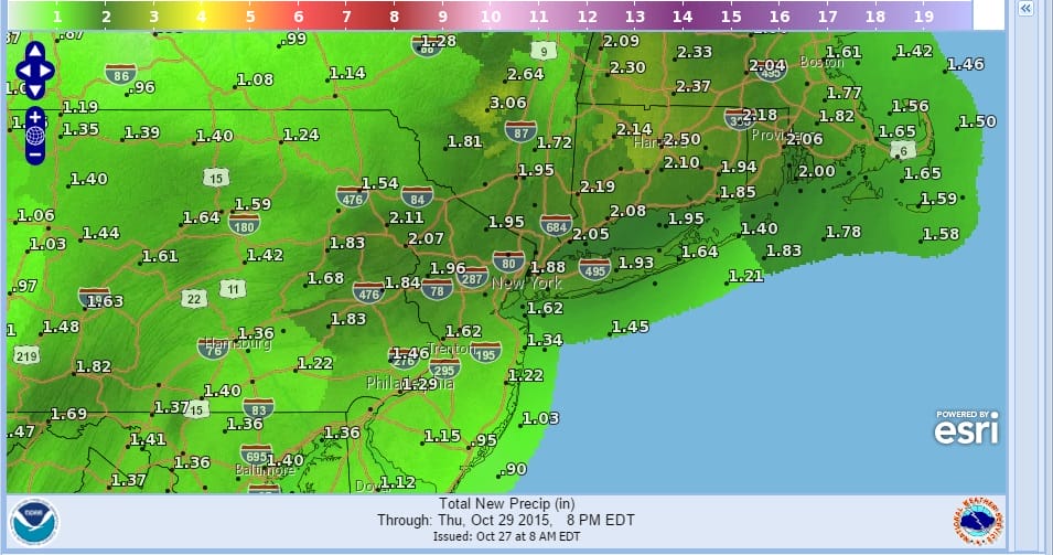
The rainfall amounts being forecast have been gradually increasing. The key to the rain will be how much over running rain develops for Wednesday during daylight hours. Rain will being before daybreak southwest of New York City and after daybreak northeast of New York City. The heaviest will occur during the late afternoon into the first part of Wednesday night until the front passes. Some thunderstorms are possible as well.
Once the front passes weather conditions improve on Thursday and it will still be mild. 50s to near 60 today and 60s on Wednesday. Thursday we could see 65 to 70 before much cooler air arrives Thursday night and Friday. Right now the weekend is looking good for Saturday with sunshine and temperatures in the 50s to near 60. Sunday is looking better as the next weather system may weaken before it gets here.
For coastal areas Gale Warnings may go up later today and tonight. The southeast to south wind could cause tidal flooding problems along the south Shore of Long Island at high tides during Wednesday.
Be sure to download my app and subscribe to my forecasts. The app is free and a subscription is just 99 cents a month.


