Rain Tuesday Thursday Friday Dry Wednesday
Rain Tuesday Thursday Friday Dry Wednesday
Flood Watch New Jersey & Hudson Valley
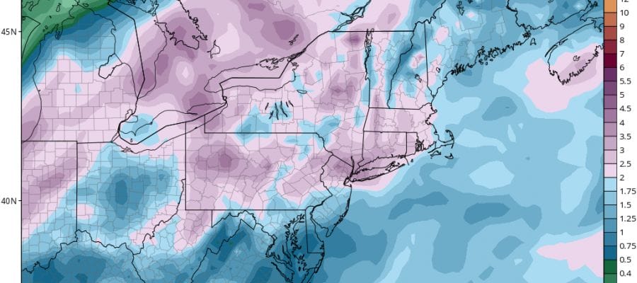
We are getting ready for the next round of 1 to 2 inch rainfalls that are about to descend upon us as low pressure moves northeast out of Oklahoma and heads for the Great Lakes. This is the system that produced the widespread severe weather outbreak across the Western Gulf States yesterday and that severe weather spreads eastward today into Alabama and Georgia. Rain will approach our are tonight but we still have some nice sunshine ahead of us today with temperatures in the 50s. Some clouds will begin increasing later this afternoon and the first rains will arrive late this evening and overnight.
SATELLITE LOOP

REGIONAL RADAR

LOCAL RADAR NEW YORK CITY

LOCAL RADAR PHILADELPHIA


Tuesday we will see rain with some of the rain heavy at times until the system passes to our north. 1 to 2 inches of rain are forecast from this. Once that goes by Wednesday is a dry day but then the next weather system is going to be headed our way for Thursday and this one in some ways will be stronger and take longer to play through. Thursday we could see a windswept rain and perhaps even a few thunderstorms may come into play. The southeast inflow will be strong with this as intense low pressure heads to the Eastern Great Lakes.
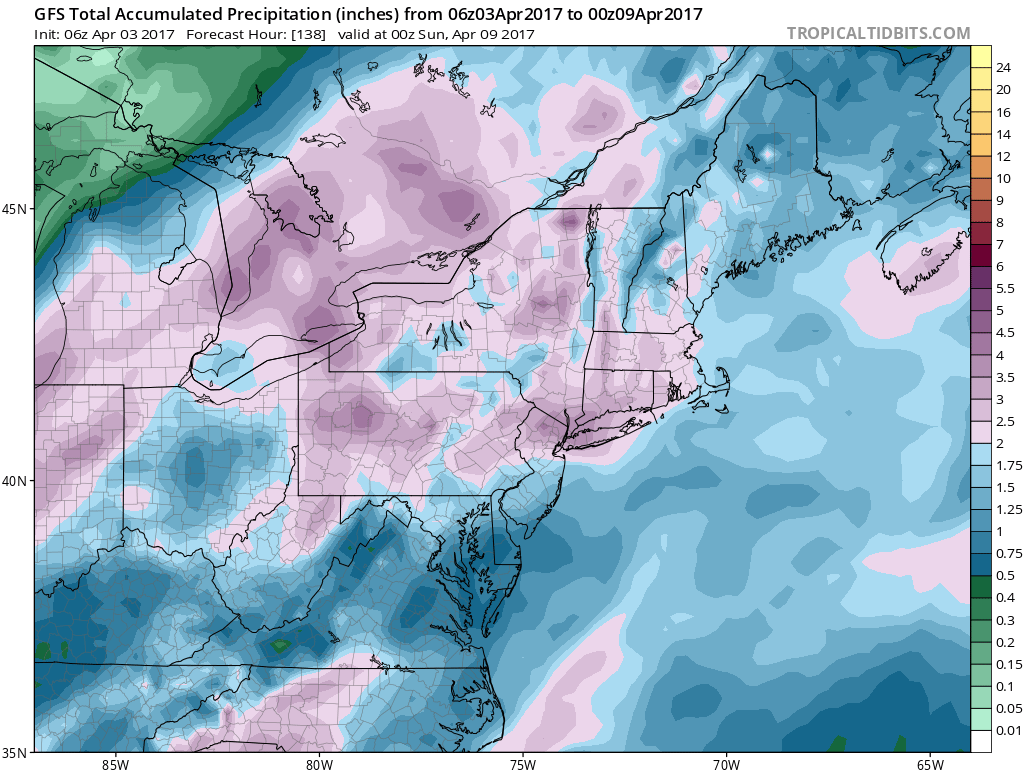
The second weather system may take until Saturday before it moves out of the way. When it is all said and done this week we will perhaps see 4 to 5 inches of rain in some places. Now once this storm is done and pulls out over the weekend it could be setting us up for a couple of days of warm weather for next week. We will explore that option later today but we could see a couple of days of temperatures into the 70s which would be very nice. GET JOE A CIGAR IF YOU LIKE
LANDSCAPE COMPANIES FOR YOUR NEEDS
LONG ISLAND ROCKLAND COUNTY Connecticut

![]()

ROCKLAND COUNTY TRI STATE SNOW REMOVAL JOHNSTOWN PA


FiOS1 News Weather Forecast For Long Island
FiOS1 News Weather Forecast For New Jersey
FiOS1 News Weather Forecast For Hudson Valley
NATIONAL WEATHER SERVICE SNOW FORECASTS
LATEST JOESTRADAMUS ON THE LONG RANGE
Weather App

Don’t be without Meteorologist Joe Cioffi’s weather app. It is really a meteorologist app because you get my forecasts and my analysis and not some automated computer generated forecast based on the GFS model. This is why your app forecast changes every 6 hours. It is model driven with no human input at all. It gives you an icon, a temperature and no insight whatsoever.
It is a complete weather app to suit your forecast needs. All the weather information you need is right on your phone. Android or I-phone, use it to keep track of all the latest weather information and forecasts. This weather app is also free of advertising so you don’t have to worry about security issues with your device. An accurate forecast and no worries that your device is being compromised.
Use it in conjunction with my website and my facebook and twitter and you have complete weather coverage of all the latest weather and the long range outlook. The website has been redone and upgraded. Its easy to use and everything is archived so you can see how well Joe does or doesn’t do when it comes to forecasts and outlooks.
Just click on the google play button or the apple store button on the sidebar for my app which is on My Weather Concierge. Download the app for free. Subscribe to my forecasts on an ad free environment for just 99 cents a month.
Get my forecasts in the palm of your hand for less than the cost of a cup of Joe!


