
Rain Moving Through, Cooler Saturday, Records Sunday
Rain moving off the New Jersey Coast this evening will bring wet weather mainly south of Route 78 in New Jersey & Pennsylvania for another few hours before moving out. North of 78 the rain diminishes in coverage and intensity. Rain moving across Long Island will be lightest as this area is on the northernmost fringe of the rain. Once this area moves offshore the rest of the night should see temperatures cool down into the mid 40s to near 50 by daybreak.
Saturday will be cooler with clouds around but rain should hold off until after sundown. Warmer air and rain will be moving across the area Saturday night. This sets us up for some sun and clouds early Sunday with more record highs in the 60s. This should be the last day of record highs for quite awhile as a cold front moves through with some showers Sunday afternoon. Much colder air returns for Monday and many areas will not be out of the 30s. Monday dayside will be dry but we have a storm coming out of the southwest that will head to the Great Lakes. This will bring rain northward Monday night. The air will actually be cold enough in Northeast Pennsylvania, Northern New Jersey north of rt 80 and in the Hudson Valley and interior Connecticut north of the Merritt Parkway to start off as a period of snow sleet or even freezing rain. We will have more on this later tonight and on Saturday morning as we examine new model runs.


Good news for ski areas in the northeast. Some much needed and much welcomed snow is coming for many areas in upstate New York and New England with some areas doing quite well Monday night into late Tuesday from this approaching storm from the southwest.
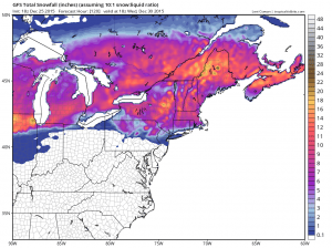
The snowfall maps showing some mountain areas upstate and in New England getting up to a foot of snow. For many areas this is the first important snowfall of the season and it comes very late in December but in time for New Years vacationers. It also marks the beginning of a long awaited pattern change which means that ski areas should see more normal temperatures from Monday onward.
LATEST JOESTRADAMUS ON THE LONG RANGE
Weather App

Winter is coming. Don’t be without Meteorologist Joe Cioffi’s weather app. It is a complete weather app to suit your forecast needs. All the weather information you need is right on your phone. Android or I-phone, use it to keep track of all the latest weather information and forecasts. This weather app is also free of advertising so you don’t have to worry about security issues with your device. An accurate forecast and no worries that your device is being compromised.
Use it in conjunction with my website and my facebook and twitterand you have complete weather coverage of all the latest weather and the long range outlook. The website has been redone and upgraded. Its easy to use and everything is archived so you can see how well Joe does or doesn’t do when it comes to forecasts and outlooks.
Just click on the google play button or the apple store button on the sidebar for my app which is onMy Weather Concierge. Download the app for free. Subscribe to my forecasts on an ad free environment for just 99 cents a month.
Get my forecasts in the palm of your hand for less than the cost of a cup of Joe!

![]()