
Rain Moving Northeastward Friday
Rain Moving Northeastward Friday
Hopefully you enjoyed whatever sunshine you managed to get yesterday because clouds are everywhere this morning as evidenced by the satellite loop. The second in a series of low pressure systems is moving through today. This one is actually going to weaken as it moves eastward so the rain you see to our west will diminish somewhat but not completely. You will see rain moving through later this afternoon and the first part of tonight. The rain will be on the order of a quarter of an inch or less and it should be done probably during the mid or late evening and certainly gone by midnight in easternmost areas.

You can see the rain moving northeastward on the radar. It is really just one arm of moisture moving toward us. Once this goes by we will stuck in clouds right through the weekend as the next order of business will be a strong noreaster that will be impacting us beginning Sunday night and lasting into Tuesday.


Saturday will be cloudy with temperatures probably in the upper 40s to maybe some lower 50s. Then Sunday we watch low pressure to our south begin to organize.
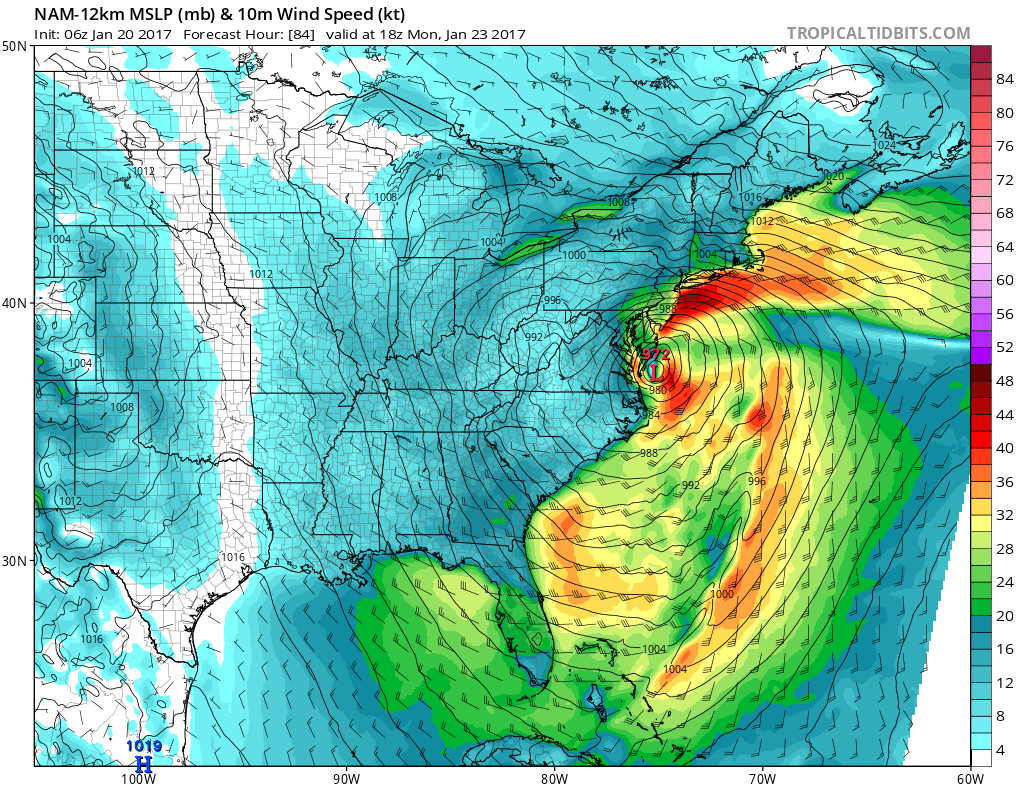
Rain from this system arrives Sunday night. At this point I think the biggest issue may be the wind they could be every bit of 30 to 45 mph along the coast with gusts to 60 mph. Inland the wind will be a bit less but there certainly could be some strong wind gusts from this. Ranifall should be on the order of 2 to 3 inches at least. Snow sleet issues are likely to be confined to areas well inland north of Route 84. We will begin to break down our expections from this storm as we move into the weekend.
SNOW REMOVAL COMPANIES FOR YOUR WINTER NEEDS
LONG ISLAND ROCKLAND COUNTY Connecticut

![]()

ROCKLAND COUNTY TRI STATE SNOW REMOVAL JOHNSTOWN PA


FiOS1 News Weather Forecast For Long Island
FiOS1 News Weather Forecast For New Jersey
FiOS1 News Weather Forecast For Hudson Valley
NATIONAL WEATHER SERVICE SNOW FORECASTS
LATEST JOESTRADAMUS ON THE LONG RANGE
Weather App

Don’t be without Meteorologist Joe Cioffi’s weather app. It is really a meteorologist app because you get my forecasts and my analysis and not some automated computer generated forecast based on the GFS model. This is why your app forecast changes every 6 hours. It is model driven with no human input at all. It gives you an icon, a temperature and no insight whatsoever.
It is a complete weather app to suit your forecast needs. All the weather information you need is right on your phone. Android or I-phone, use it to keep track of all the latest weather information and forecasts. This weather app is also free of advertising so you don’t have to worry about security issues with your device. An accurate forecast and no worries that your device is being compromised.
Use it in conjunction with my website and my facebook and twitter and you have complete weather coverage of all the latest weather and the long range outlook. The website has been redone and upgraded. Its easy to use and everything is archived so you can see how well Joe does or doesn’t do when it comes to forecasts and outlooks.
Just click on the google play button or the apple store button on the sidebar for my app which is on My Weather Concierge. Download the app for free. Subscribe to my forecasts on an ad free environment for just 99 cents a month.
Get my forecasts in the palm of your hand for less than the cost of a cup of Joe!


