
Rain Later Today Near Record Highs Possible Wednesday
Unsettled Late Week Into Weekend
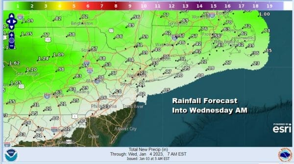
Get ready for some more very warm temperatures (for January) and some rain as we have a storm in the Plains heading for the Upper Midwest. That is pulling warm air up the East Coast. A warm front is setting up across Eastern Pennsylvania to Southern New England cutting the area in half from north to south. if we draw a line from Allentown to NYC to New Haven Connecticut; from there northward we could see a half to three quarters of an inch of rain later toda into tonight. South of that line the rain diminishes quickly in Southern New Jersey and Southern Pennsylvania southward with less than a quarter inch and in some places either less than a tenth of an inch or no rain at all.
SATELLITE

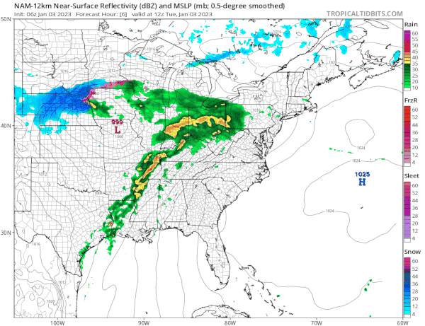
WEATHER RADAR

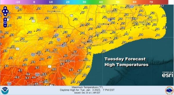
The satellite and radar bothshow evidence of how this warm front is setting up so the bottom line is that today we will see clouds thicken with some rain with again more to then north and less to the south. Temperatures today south of the warm frontal boundary will rise through the 50s and into the 60s while to the north of that boundary it will remain in the 50s.
Rain or showers will move along quickly today and we will see the rain ending from west to east late today into this evening. This leaves most of the area in the “warm sector” and we can look forward to leftover clouds tonight along with perhaps a few scattered showers along with some patchy fog. Temperatures tonight won’t be going anywhere as they hold in the 40s to lower 50s.
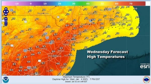
Wednesday is going to be a very interesing day from the standpoint of temperatures. We will be in the warm air and a cold front will approach and bring in some showers from west to east in the late afternoon and evening. This gives the atmosphere plenty of time to heat up. If the sun can cut through the clouds even for a brief period of a few hours, we could see temperatures soar to the mid and upper 60s and that could set off some record highs being achieved. Highs should reach mid to upper 60s and I would not be surprised fi somebody gets to 70.
Showers will pass Wednesday evening and that will leave us in leftover clouds with temperatures by Thursday morning falling to the 40s to around 50. Thursday will be much like Monday was with clouds around and perhaps some sun cutting through. Temperatures will still be well above normal but highs will lower than Wednesday in the low to mid 50s. There might be some scattered showers around Thursday but they should be few and far between. Temperatures will trend lower Friday with morning lows in the 30s and highs in the low to mid 40s. Friday will also be a little unsettled with clouds and the risk for a couple of showers with an upper air disturbance. Perhaps well inland there could be a rain or snow shower risk. The unsettled nature of the weather pattern leaves us with a little uncertainty over the weekend as weak upper air disturbances move along and temperatures continue to trend lower and closer to normal for this time of year.
BE SURE TO DOWNLOAD THE FREE METEOROLOGIST JOE CIOFFI WEATHER APP &
ANGRY BEN’S FREE WEATHER APP “THE ANGRY WEATHERMAN!
MANY THANKS TO TROPICAL TIDBITS & F5 WEATHER FOR THE USE OF MAPS
Please note that with regards to any severe weather, tropical storms, or hurricanes, should a storm be threatening, please consult your local National Weather Service office or your local government officials about what action you should be taking to protect life and property.


