Rain Late Tonight Burst of Snow Inland, On & Off Rain Into Thursday, Very Cold Late Week
We didn’t see much change as we looked at weather models this afternoon and evening. Everything seems to be moving along according to plan. Low pressure is moving across the Great Lakes with a front approaching us. The satellite pictures and loops are showing clouds rolling in and we will likely see precipitation move in during the early morning hours and lasting just past daybreak.
SATELLITE

REGIONAL RADAR

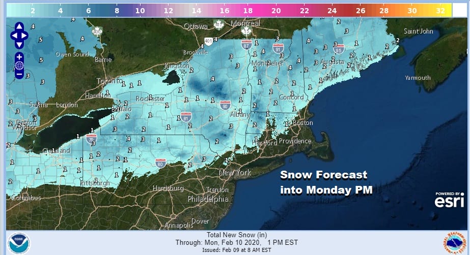
Regional radar is picking up some snow moving into Western Pennsylvania. The southern end of this will likely be rain with the snow going well north and west of Philadelphia and NYC. Local radars should start picking up some echos in a few hours.
LOCAL RADAR NEW YORK CITY

LOCAL RADAR PHILADELPHIA


The first wave will bring a cold front down to the coast on Monday but it will be the second wave for Monday night and Tuesday that will push the front well to the south into the Carolinas. Rain or whatever precipitation is going on (snow well north) will end a bit after daybreak. It will then start up late Monday into Tuesday afternoon…first along the coast and later on tomorrow night inland and north. Temperatures overnight will hold mostly in the 30s. Snowfall forecasts remain mostly unchanged from earlier today.
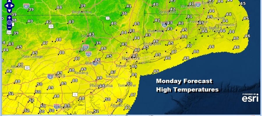
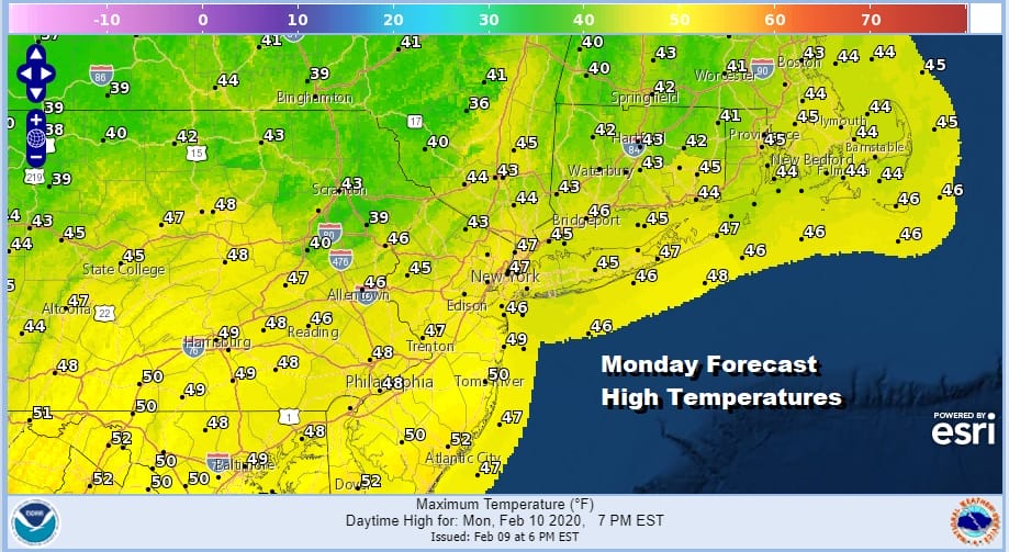
Monday’s highs will be in the mid to upper 40s except for low 50s possible Southern New Jersey south and west. Once the rain ends Tuesday afternoon we will see temperatures settle in the 40s and drop to the 20s to near 30 by Wednesday morning.
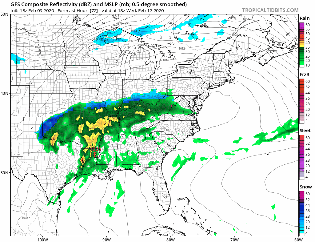
The last wave in the series arrives late Wednesday into Wednesday night with snow on the northern flank of this that will move into upstate NY and New England..changing to rain in southern areas down near the coast and points south into New Jersey and Southern Pennsylvania. Once this storm plays through Thursday very cold air is poised to move in for the end of the week and the weekend. This may likely be the coldest weather of the last 6 weeks (which haven’t exactly been all that cold.
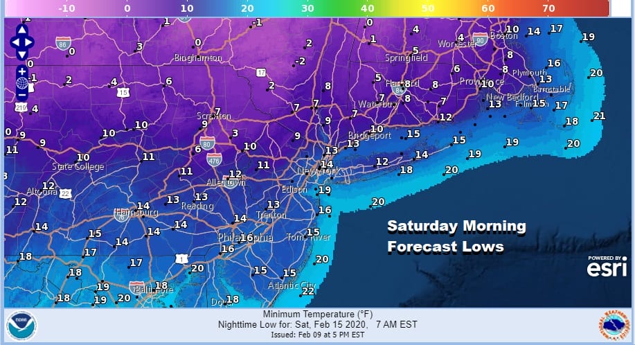
Friday morning we will be in the 20s and likely stay in the 20s all day before dropping to the low teens and single digits Friday night into Saturday morning. At least we will have some sun back by the end of the week and this coming weekend. Saturday’s highs will be just in the 20s. Perhaps we could see a bit of moderation in temperatures later next Sunday. Once again the cold air arrives too late for snow lovers as the storm system for Wednesday night into Thursday comes in a little faster and the cold air arrives a little slower. We haven’t seen much in the way of cold since before Christmas and even less in the way of snow. There isn’t much change in the long range as the weather pattern remains pretty much the same story. Only if a window of opportunity presents itself with cold air around at the same time we get a storm system will we see any accumulating snow in the I-95 corridor in the coming weeks.
BE SURE TO DOWNLOAD THE FREE METEOROLOGIST JOE CIOFFI WEATHER APP &
ANGRY BEN’S FREE WEATHER APP “THE ANGRY WEATHERMAN!
MANY THANKS TO TROPICAL TIDBITS FOR THE USE OF MAPS
Please note that with regards to any severe weather, tropical storms, or hurricanes, should a storm be threatening, please consult your local National Weather Service office or your local government officials about what action you should be taking to protect life and property.


