Rain Ends With Improving Weather Conditions Later Today
Sometimes and thankfully not that often things seem to come together a bit differently than what you envisioned. We are seeing the result this morning with rain on the radar that developed overnight. We have been waiting for one last wave to develop and move out offshore bringing down dry air. This should have happened late yesterday and last night. Instead it is happening now and it is makinf for a wet start to the day. Weather conditions should improve later today with decreasing clouds and increasing afternoon sunshine with highs in the upper 70s to lower 80s. This wave will push out to the east and the dry air that is in upstate NY & New England will finally make its way southward.
SATELLITE

REGIONAL RADAR

The regional and local radars this morning are showing light to moderate rain with a few patches of heavy rain over Eastern Pennsylvania southward to Maryland and east to New Jersey into Long Island.. This area will sink southward and east over and gradually diminish.
LOCAL RADAR NEW YORK CITY

LOCAL RADAR PHILADELPHIA


Skies should clear out tonight with most lows in the 60s . Tuesday and Wednesday look nice and sunny with no complications and highs into the 80s Tuesday and well into to the 80s to near 90 Wednesday. The enxt cold front is still on course for Thursday with the chance for showers and thunderstorms with highs in the 80s.

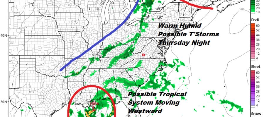
While all of this is going on the southern part of this stalled frontal boundary to our south sees a piece of it essentially break off and drop southward into the Eastern Gulf of Mexico. From there this system will move westward just to the south of the Gulf coastal areas.

Upper air conditions are favorable for development here as we hill have relatively light wind shear conditions aloft along with very warm water temperatures and a good inflow pattern setting up. The National Hurricane Center rates this an 80% chance of development and it will probably develop as long as the surface low evolves far enough offshore. The low is going to be trapped underneat the next high building across the Eastern US late this week so this favors a westerly or west northwest course across the Gulf of Mexico. First things first though and we have to see where the low winds up developing before we start speculating any further here.
MANY THANKS TO TROPICAL TIDBITS FOR THE USE OF MAPS
Please note that with regards to any tropical storms or hurricanes, should a storm be threatening, please consult your local National Weather Service office or your local government officials about what action you should be taking to protect life and property.


