Rain Ending Weather Conditions Improve Later Today Thanksgiving Week Outlook
The weekend does start off a bit damp and wet as low pressure heads off the Mid Atlantic coast. That will take the rain out to sea and by midday the rain will be gone. Drier air will be coming in on the backside of this system so weather conditions should improve this afternoon though it will be slowly. Look for leftover decreasing clouds once the rain is done and temperatures today will be mostly in the lower 50s for highs.
SATELLITE WITH LIGHTNING STRIKES
WEATHER RADAR
Most lows tonight will be in the upper 20s to middle 30s as skies become partly to mostly clear. Sunday we will see a slightly colder air mass build into New England and that will keep temperatures somewhat in check. Skies should be no worse than partly sunny. Temperatures Sunday afternoon will be in the upper 40s to some lower 50s with no rain in the forecast.
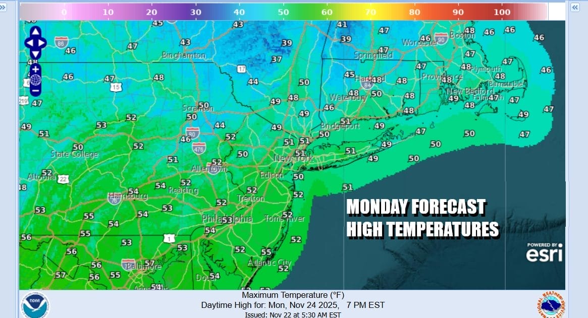
Thanksgiving week is going to start dry as we have high pressure overhead Monday and moving slowly offshore. This is going to be followed by another weather system heading for the Great Lakes and a trailing cold front that will approach the East Coast Tuesday. This is our once chance for precipitation this week and it will be more of a nuisance than anything as it is poised to move through without creating any complications.
This weather front will be followed by a rather cold air mass that will be dropping into the entire Eastern US for Thanksgiving day and also for Friday with below average temperatures for everyone east of the Mississippi River. At least we have no major storms in the week ahead to create additional travel headaches for those of you heading elsewhere for the Thanksgiving holiday.
Monday will be chilly but dry with plenty of sunshine and most highs in the upper 40s and lower 50s. We will warm Tuesday with highs in the mid to upper 50s. Clouds will increasing with showers developing from west to east during Tuesday afternoon and lasting into Wednesday morning. Tuesday highs will be in the 50s to near 60 degrees in warm spots. Wednesday with the front passing offshore and any rain ending in the morning, weather conditions will improve in the afternoon. Leftover warm air will mean highs in the 50s to near 60. However in comes much colder air for Wednesday night and Thanksgiving day.
An early look at Thanksgiving day shows a cold and breezy day with clouds and some sunshine. High temperatures however will be just in the 40s and it will be even colder Thursday night and Friday as a cold air mass settles in. Friday highs may only be in the upper 30s and lower 40s with sunshine. At least we have no major storms or major precipitation events to worry about for the next week or so and certainly no worries surround Thanksgiving.
BE SURE TO DOWNLOAD THE FREE METEOROLOGIST JOE CIOFFI WEATHER APP \\\&
ANGRY BEN’S FREE WEATHER APP “THE ANGRY WEATHERMAN!
MANY THANKS TO TROPICAL TIDBITS FOR THE USE OF MAPS
Please note that with regards to any severe weather, tropical storms, or hurricanes, should a storm be threatening, please consult your local National Weather Service office or your local government officials about what action you should be taking to protect life and property.