
Quiet Days Continue Warming Saturday 50s Before Cold Returns
Chance for Snow Sunday?

Quiet Days Continue Warming Saturday 50s Before Cold Returns
Chance for Snow Sunday?

Our quiet phase of this weather pattern we have been continues this week. Weak storms head off the Florida coast and out to sea to the northeast. We are not sitting in arctic air for a change so we will have a nice day of sunshine today. Temperatures are going to be a little above average as most highs will reach the low and mid 40s. The radar takes a break for the next few days. Even though we do have a cold front coming through tonight, it isn’t much of one and you won’t notice much of a difference over the next few days. There might be a brief rain or snow shower tonight when the front goes by but the chances are very low. Lows tonight will be in the upper 20s to lower 30s.
SATELLITE

WEATHER RADAR

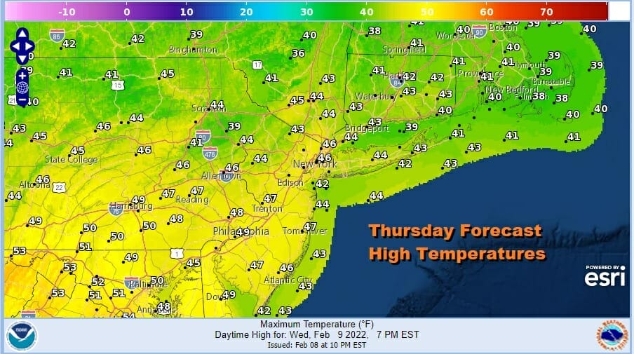
Thursday will be a partly sunny day on the other side of that front with a northwest breeze. Highs will be in the low to mid 40s. However areas in South Jersey and Southern Pennsylvania could see highs approach or even break over 50. Friday will be a nice sunny day with similar temperatures. Highs again will be in the mid 40s to lower 50s.
Temperatures will go nowhere Friday night bottoming in the mid 30s to lower 40s so the launching pad is set. Saturday starts the next round of changes. An arctic front will be approaching with its cold air mass behind it. We may start the day with some sun but clouds will roll in. There isn’t much precipitation ahead of the front other than a passing shower.

The timing of the front is for later in the day so if that is the case, then temperatures will rise to the mid and upper 50s in many locations. North of NYC it will be a little lower but upper 40s and lower 50s will be quite common. HOWEVER if the front arrives sooner that could reduce the highs especially from NYC west and north. Either way the front passes, colder air moves in and lows by Sunday morning will be in the 20s to around 30 degrees.
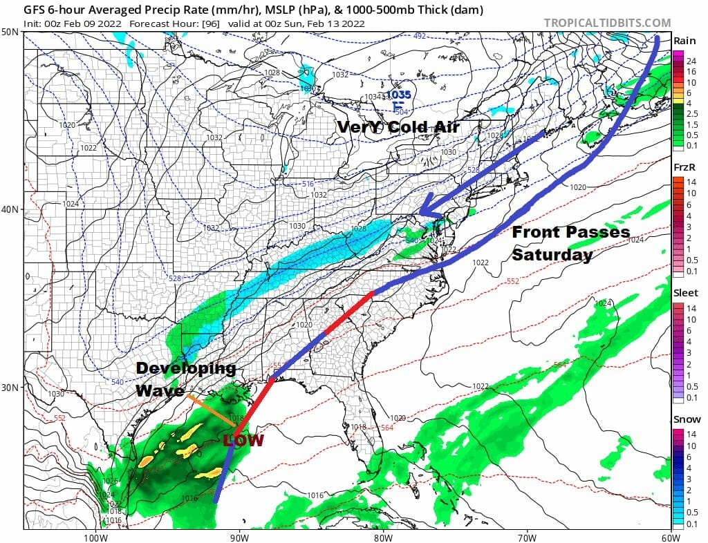
Now comes the tougher part of the forecast. The arctic boundary stalls to our south. We will have a cold northeast flow off the ocean around the east side of the high as it builds into Eastern Canada and New England. The flow aloft is from the southwest and we will likely have cloudy skies with the possibility of some light snow developing, much the same way it did the Friday before the January 28-29th storm. Low pressure will be developing off the Florida coast and begin its move northeastward.

The set up for this storm is eerily similar to the January 28-29th storm however there are important differences in the upper air this time around at least from what is being indicated right now. The upper air set up is almost the same. We face the same questions this time around 5 days before. Does the upper trough in the Great Lakes act as a kicker and push the worst of it offshore or does it dig down and lift it up to the northeast closer to the coast? We have seen repeatedly this winter storm systems forecast to track offshore in the long range only to see them come back westward. Monday’s system was forecast to pass well to the east and we wound up with rain as far west as Eastern Pennsylvania as the low tracked just offshore.
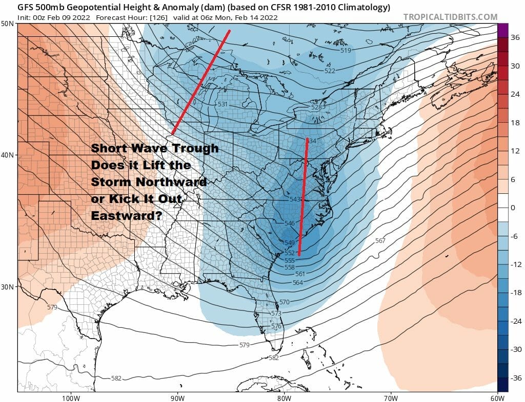
The snow shield is pulled back rather far westward but this is due to the proximity of the lead short wave approaching the coast. We are still 5 days away and we have lots of model runs to get through yet and there will be more changes coming in how this plays out. Other models are likely to show their own solutions to this that are likely to differ somewhat from what the GFS shows as they struggle with all the energy running around. I’m getting a little more interested in this set up. At least we have some quiet and calm conditions into the start of the weekend.
BE SURE TO DOWNLOAD THE FREE METEOROLOGIST JOE CIOFFI WEATHER APP &
ANGRY BEN’S FREE WEATHER APP “THE ANGRY WEATHERMAN!
MANY THANKS TO TROPICAL TIDBITS & F5 WEATHER FOR THE USE OF MAPS
Please note that with regards to any severe weather, tropical storms, or hurricanes, should a storm be threatening, please consult your local National Weather Service office or your local government officials about what action you should be taking to protect life and property.


