Quick Shot of Chilly Air Winds Slowly Ease Warmer Into Saturday
All high wind warnings and wind advisories are discontinued. While we did see strong winds gusting to 50 mph overnight, our storm system to the northeast is moving out faster to the east so the gradient has relaxed to some extent. It will be a breezy day and much of Eastern Pennsylvania to Southern New England will see sunshine along with a few clouds. Temperatures this afternoon will be on the cool side with most highs in the middle 50s, a little lower to the north and a little higher to the south. There is some lake effect precipitation going on in Upstate NY but we do not expect any of what is on the radar to head down closer to the coast.
SATELLITE WITH LIGHTNING STRIKES
WEATHER RADAR
The gradient will continue to relax overnight so winds will ease further as high pressure settles over the Mid Atlantic states. Warmer urban areas will bottom in the lower 40s while areas inland, especially where winds drop off to dead calm will see lows below freezing and even in the 20s in the coldest spots inland. Friday we will begin to warm up ahead of another approaching weather front.
We will see sunshine giving way to arriving clouds Friday with highs back into the upper 50s and lower 60s. Friday night into Saturday morning another cold front will approach and pass. We will likely see some showers when the front goes by. The air behind this cold front is about the same as the air ahead of it however another cold front will a developing low in the Ohio Valley will push eastward Sunday.
This weather front for Sunday has a solid shot of very cold air (for this time of year) coming down behind it and that Ohio Valley low heads northeast pushing the cold front toward the coast. We will see some showers as that front goes by and that will be followed by the coldest air of the season so far with December like temperatures spreading throughout the Great Lakes, Ohio & Tennessee Valleys, and the entire East Coast even reaching into Florida early next week. There will be lake effect snows from this as well as snow in the Appalachians as far south as North Georgia Monday.
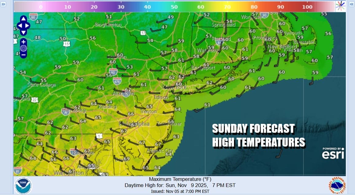
Ahead of this Saturday is going to be warm with sunshine taking highs to the mid and upper 60s. I would not be surprised to see some warm spots push to 70 degrees for a high. Sunday we will see increasing clouds with showers overspreading the area from south to north during the afternoon and evening. Sunday highs will also be in the 60s.
Cold air will move into the Eastern US Sunday night and especially Monday. A cold upper trough will be moving through so we will likely see self destruct sunshine, gusty winds, and perhaps even some snow showers especially inland. Monday highs will just be in the 40s and we will be down in the 20s in many areas Tuesday morning. Tuesday we will see sunshine but highs again only in the low to middle 40s.
BE SURE TO DOWNLOAD THE FREE METEOROLOGIST JOE CIOFFI WEATHER APP &
ANGRY BEN’S FREE WEATHER APP “THE ANGRY WEATHERMAN!
MANY THANKS TO TROPICAL TIDBITS FOR THE USE OF MAPS
Please note that with regards to any severe weather, tropical storms, or hurricanes, should a storm be threatening, please consult your local National Weather Service office or your local government officials about what action you should be taking to protect life and property.