Powerful Blocking Signal Could Suppress Storms South & East
Powerful Blocking Signal Could Suppress Storms South & East
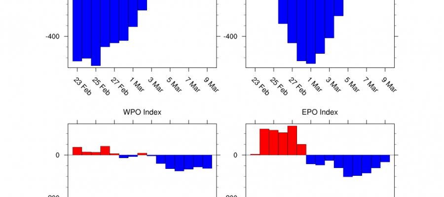
Those of you who want to see another round of winter weather should understand that for you there could be too much of a good thing. Blocking is already developing between Scandinavia & Greenland. This is going to bring brutal cold air to Europe and may wind up producing a snowstorm or two for areas in Northwest Europe including England & Ireland in the long range. The block causes air from Siberia to sweep westward into Western Europe. The blocking signal as shown above by the teleconnection forecasts as showing an absolute off the wall reading and it could be the strongest blocking signal we have seen in nearly 7 years! The blocking signal would create storm tracks to the south of our area andwill bring colder air into the Eastern US. That cold air however is not going to be of the same magnitude of what Europe is going to see. The other important signal here is the Pacific North America Index is off the wall negative as well and that makes all of this even more problematic.
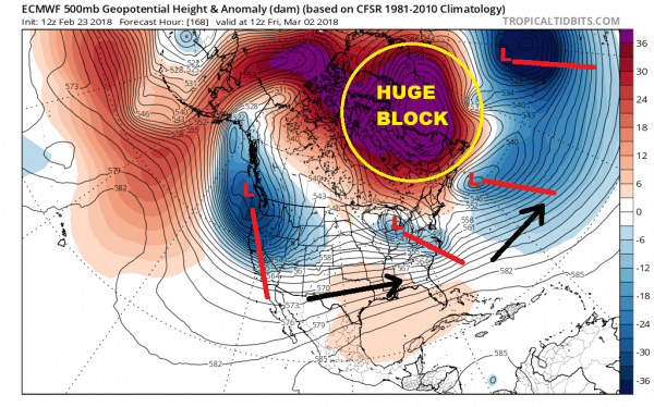
EUROPEAN MODEL FRIDAY MARCH 2, 2018
All of Canada is covered with high pressure in the upper atmosphere as well as the North Atlantic. The jet stream which normally is stronger north of 50 degrees north latitude is instead well south of normal between 30 degrees north and 40 degrees north. You can see the parade of storms that are showing up. They are much further south that then otherwise would be and much further south then they have been all winter long. All the weather models have this signal with the European & Canadian models showing the strongest blocking signatures while the GFS is strong but perhaps a bit less so. One of the problems with the long range forecast models right now is that the atmosphere is now being stretched to extremes again and this will make models more volatile than normal. This is why sometimes we see storm threats in the long range and sometimes they are more suppressed, further south, and weaker. The first threat for something to happen here will be in a week when a system moving across the East makes its way to the coast. The European doesn’t allow for much room. There is a storm to the east out at 60 degrees west.
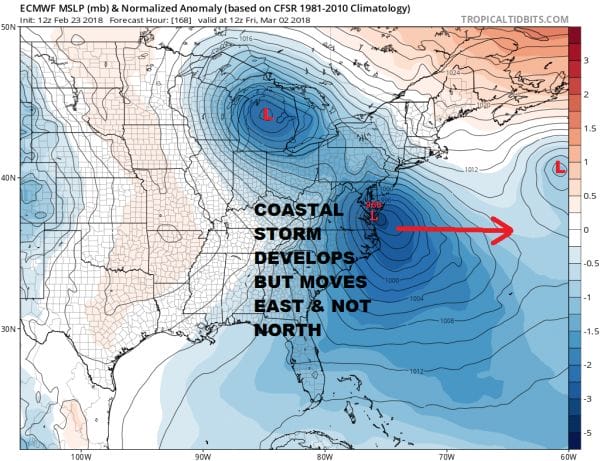
EUROPEAN SURFACE FORECAST FRIDAY MARCH 2, 2018
The problem here is that the block is actually too strong. If the European is correct this storm may wind up moving east or southeast rather than northeast. Too much blocking will suppress and prevent the storm from lifting up northward. Also if we look out west we have a trough that is still hanging along or just inland of the West Coast. A ridge in that position would support a system that could move more east northeast or northeast however an even bigger issue is in the Atlantic with a nearby low out to the east near 40 N & 60 W. You can see that low on the edge of the graphic on the right. If this look is correct there may not be much room if any room at all.
All that said we should caution that the block makes all of this a highly unstable proposition at this point. How the model sees the strength of the block is going to be key along with how the Atlantic Ocean sets up with its parade of storms. We have much to watch here but remember that you could have all the blocking in the world but if the highs and lows aren’t in position, you wind up with very little to worry about.
SHOP THE JOESTRADAMUS STORE
MANY THANKS TO TROPICAL TIDBITS FOR THE WONDERFUL USE OF THE MAPS
GET JOE A CIGAR IF YOU LIKE!
FiOS1 News Weather Forecast For Long Island
FiOS1 News Weather Forecast For New Jersey
FiOS1 News Weather Forecast For Hudson Valley
NATIONAL WEATHER SERVICE SNOW FORECASTS
LATEST JOESTRADAMUS ON THE LONG RANGE


