
Polar Vortex Split GFS Forecast

Today’s run of the GFS as well as the European models continue to advertise a return to a more wintry pattern after we get through a storm in the Great Lakes for the middle of next week. The interesting development today was on the GFS model in the long range. It shows a split in the polar vortex at the highest levels of the atmosphere. We have been addressing that issue from time to time lately and today’s day run was certainly showing a very bullish view on this idea.
Polar Vortex Split GFS Forecast
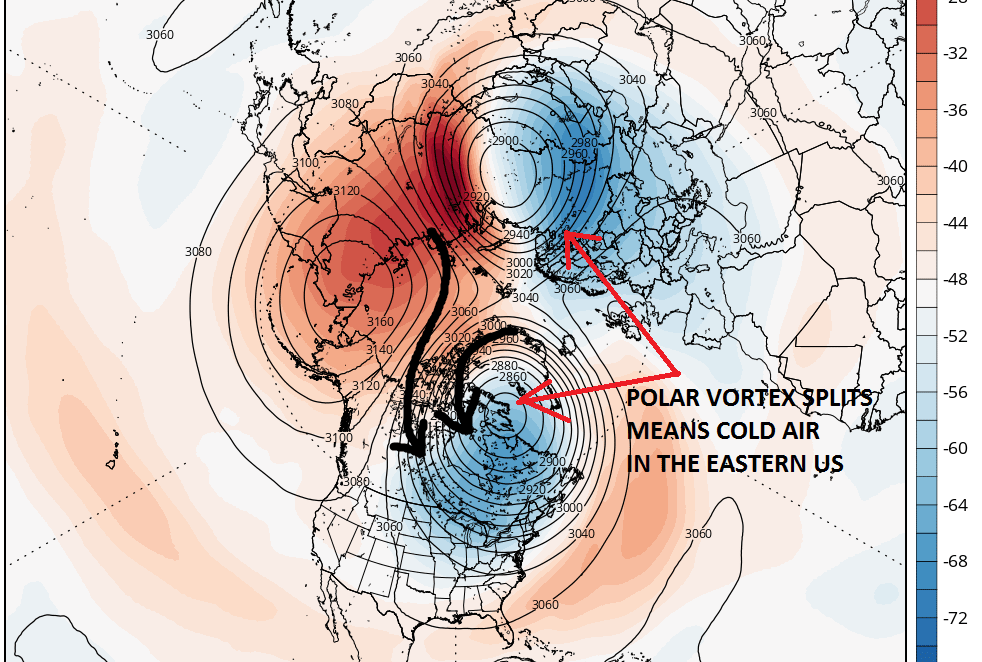
Now many of you have been asking why this is important. The reason is that the highest levels of the atmosphere we see the ultimate driver of the weather at lower levels. When changes take place here, they translate to the lower atmosphere a week or two later. Now we are speaking in the general sense here. It doesn’t mean it cant get warm for a day or so, and it doesn’t necessarily mean another snow storm. It does mean that it might set up a favorable pattern for more prolonged cold and snow. The black arrows show a cross polar flow. In other words the air is moving from Siberia and the Arctic and into the United States as indicated by the arrows. The big question is if the split occurs as forecast which is shown to begin around day 9.
While that is the long term views, the slightly shorter term view is shown by the European ensemble forecast and it appears bullish as we head into the 7 to 10 day time range.
Polar Vortex Split European Ensemble
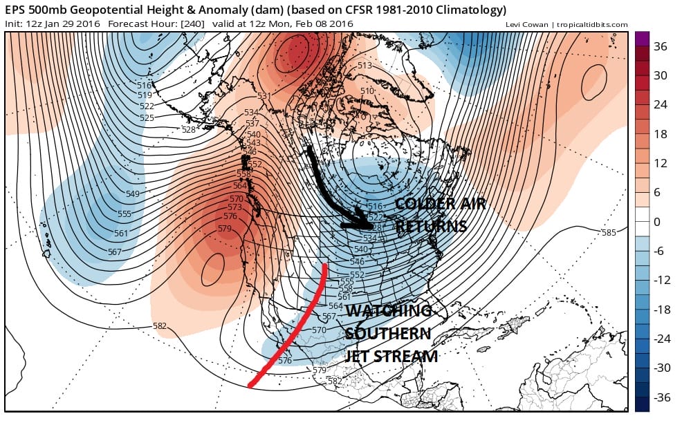
The European Ensemble at day 10 shows a cold polar flow from Canada and an active southern stream. Once again how this plays out in the long range remains to be seen. There can be all sorts of complications as we know in the short range so this is not a prediction that anything is imminent. The setup does however indicate that the odds are higher for another stretch of volatility in the atmosphere.
Polar Vortex Split GFS Forecast VIDEO
More can be seen on this on my video ATTACK of the Polar Vortex Part 2. Its better than Star Wars. And don’t forget to subcribe to my You Tube videos. Its FREE!!!!
NATIONAL WEATHER SERVICE SNOW FORECASTS
LATEST JOESTRADAMUS ON THE LONG RANGE
Weather App

Winter is here! Don’t be without Meteorologist Joe Cioffi’s weather app. It is a complete weather app to suit your forecast needs. All the weather information you need is right on your phone. Android or I-phone, use it to keep track of all the latest weather information and forecasts. This weather app is also free of advertising so you don’t have to worry about security issues with your device. An accurate forecast and no worries that your device is being compromised.
Use it in conjunction with my website and my facebook and twitterand you have complete weather coverage of all the latest weather and the long range outlook. The website has been redone and upgraded. Its easy to use and everything is archived so you can see how well Joe does or doesn’t do when it comes to forecasts and outlooks.
Just click on the google play button or the apple store button on the sidebar for my app which is onMy Weather Concierge. Download the app for free. Subscribe to my forecasts on an ad free environment for just 99 cents a month.
Get my forecasts in the palm of your hand for less than the cost of a cup of Joe!

![]()