Pattern Change Clues Appearing

Pattern Change Clues Appearing
It is has been my observation over the course of many years of being tortured in the forecasting world that winters often come with a primary pattern that is interrupted with a break of up to several weeks in between. Sometimes the breaks are shorter or in rare instances no break at all. This winter seems to be playing into the 2 to 3 week break scenario and we are in such a break at the moment. We are at the beginning of this break and it seems that a few clues are beginning to appear that need to watched over the next 2 weeks or so to see if this pattern flip back plays out according to plan.
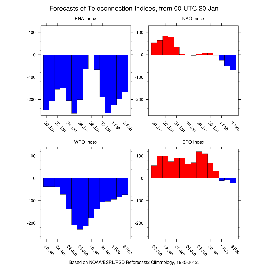
The teleconnection indices which measure pressure changes over various geographic areas in the Northern Hemisphere are showing some hints that the a flip back is on course for sometime in February. If I had to guess the process will begin sometime during the first 10 days of the month. The East Pacific Oscillation is the one that is the most important regarding cold. That index was strongly negative from mid December until recently. When it is strongly negative coupled with a few other atmospheric indicators it is usually a signal for cold weather in the east. It remains weakly positive right now however for the last several days, the indices have been showing a turn to negative at the beginning of February. The Pacific North America index is in a strong negative position which is not favorable for persistent wintry weather in the east but it is forecast to be very volatile. The index is forecast to begin rising toward neutral as the EPO heads south. The third player in this is the NAO or North Atlantic Oscillation which I regard as the least important of the bunch. Perhaps this may be the bigger difference in the second half of the winter. It continues to signal to drop to negative. A negative NAO mean an increasingly blocky pattern. Perhaps that may be the big difference for the second half of the winter but we remain open minded regarding this indicator since it tends to be the most volatile of the 3.
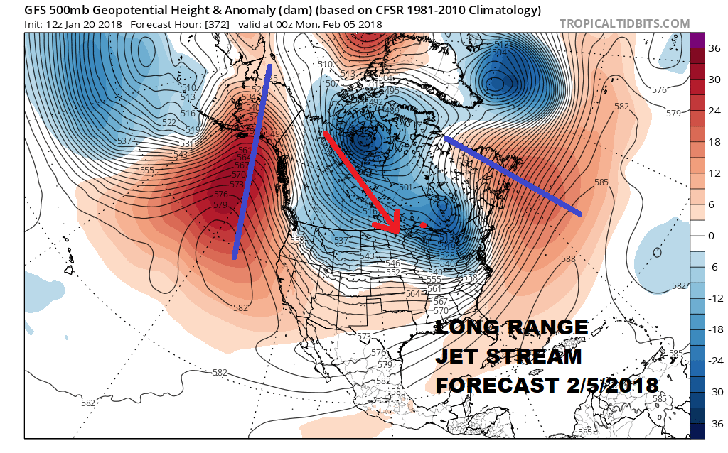
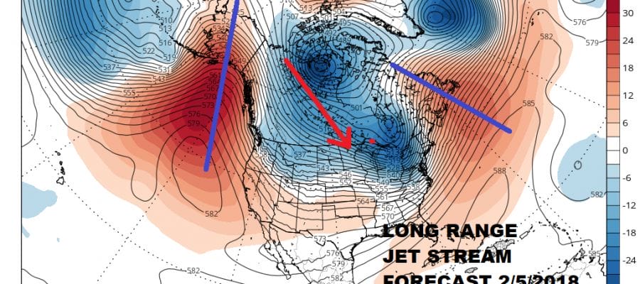
I pulled up the long long range of the GFS today and while I don’t expect it to be exactly right, the model may be picking up on the idea of the teleconnection changes in the longer term. The polar flow gets reestablished somewhat with a strong ridge off the West Coast and a ridge out in the Atlantic to the east. This would suggest a colder set up across North America should this verify. Remember that pattern changes are not events. They are processes that sometimes can be rather long and grinding. Right now to me it looks like the atmosphere is moving chess pieces around for the second act. We will have to patiently watch to see what evolves in the coming weeks. Remember that even in winters like 95-96 which were cold and snowy in the East also had a 2-3 week break from the primary pattern. What we are seeing here now is completely normal. The rubber band was stretched pretty far and has now snapped back. We will have to wait and see if the players show up in order for it to be stretched a second time.
MANY THANKS TO TROPICAL TIDBITS FOR THE WONDERFUL USE OF THE MAPS

GET JOE A CIGAR IF YOU LIKE!
FiOS1 News Weather Forecast For Long Island
FiOS1 News Weather Forecast For New Jersey
FiOS1 News Weather Forecast For Hudson Valley
NATIONAL WEATHER SERVICE SNOW FORECASTS
LATEST JOESTRADAMUS ON THE LONG RANGE
Weather App

Don’t be without Meteorologist Joe Cioffi’s weather app. It is really a meteorologist app because you get my forecasts and my analysis and not some automated computer generated forecast based on the GFS model. This is why your app forecast changes every 6 hours. It is model driven with no human input at all. It gives you an icon, a temperature and no insight whatsoever.
It is a complete weather app to suit your forecast needs. All the weather information you need is right on your phone. Android or I-phone, use it to keep track of all the latest weather information and forecasts. This weather app is also free of advertising so you don’t have to worry about security issues with your device. An accurate forecast and no worries that your device is being compromised.
Use it in conjunction with my website and my facebook and twitter and you have complete weather coverage of all the latest weather and the long range outlook. The website has been redone and upgraded. Its easy to use and everything is archived so you can see how well Joe does or doesn’t do when it comes to forecasts and outlooks.
Just click on the google play button or the apple store button on the sidebar for my app which is on My Weather Concierge. Download the app for free. Subscribe to my forecasts on an ad free environment for just 99 cents a month.
Get my forecasts in the palm of your hand for less than the cost of a cup of Joe!