
Our Nice Weather Continues Into the Weekend
We enjoyed a beautiful day of deep blue skies, sunshine, warm temperatures and low humidity. Our nice weather continues tonight. There isn’t much happening satellite or radar wise. Some of the fair weather clouds inland will dissipate and skies will be mostly clear and temperatures by morning will be in the 60s with 50s across cooler inland areas. There are no weather issues for Friday with mainly sunny skies. There is a cold front that will be moving through Friday evening and there may be a few clouds with that as it goes by but no showers are forecast. Highs Friday will be in the low to mid 80s and the humidity will be a little higher but it should still be on the reasonable side.
SATELLITE

REGIONAL RADAR

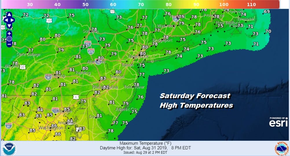
On to the weekend where we have a big high building in from the Great Lakes into New England much like last week. We should see a good deal of sunshine though there may be a few patchy clouds around across Southern Pennsylvania and Southern New Jersey. Saturday will be a nice day with bone dry humidity and highs in the 70s to near 80.
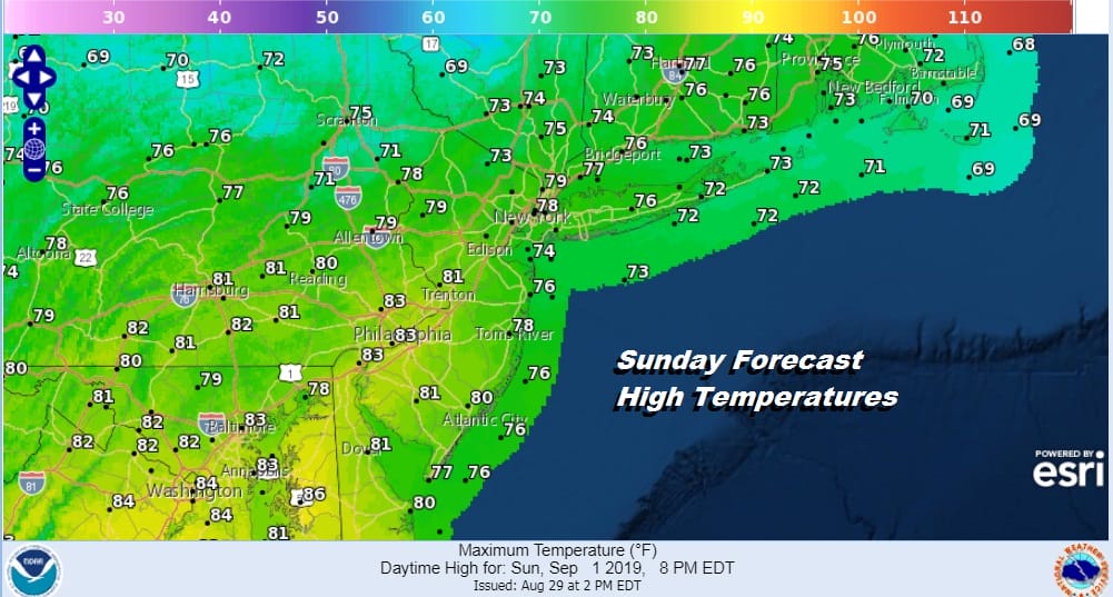
Sunday the high moves to the east and that will bring in some ocean clouds to mix with the sun. It should still be a nice enough day with partly sunny skies and most highs in the 70s. I was thinking there might be the chance for a spot shower but it appears that the air should still be dry enough so I am leaving the chance for a shower out of the forecast.
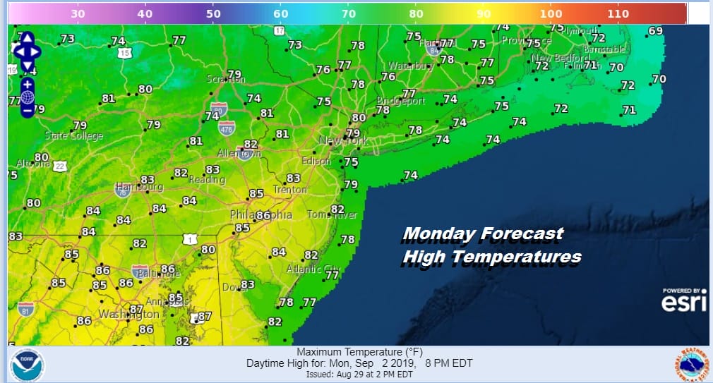
Monday Labor Day may be the one day where clouds issues mask more of the sun away. The atmosphere will be come a bit more humid so here we through in the chance for a scattered shower. Combine that with an east wind and temperatures in the upper 70s to lower 80s though it may be a bit warmer as you head south of NYC.
While we are enjoying a decent weekend Florida will be dealing with Hurricane Dorian. Afternoon weather models today seem to be zeroing in on the Florida east coast with land fall somewhere from near Daytona on the northern end of the weather model envelope to just north of Miami on the southern end of the envelope. One development overnight and today is that the track of the storm is slower and landfall on today’s runs would be no earlier than Monday night or Tuesday morning. Forward motion is being impacted by a building high to the north and a developing low in the Gulf of Mexico.
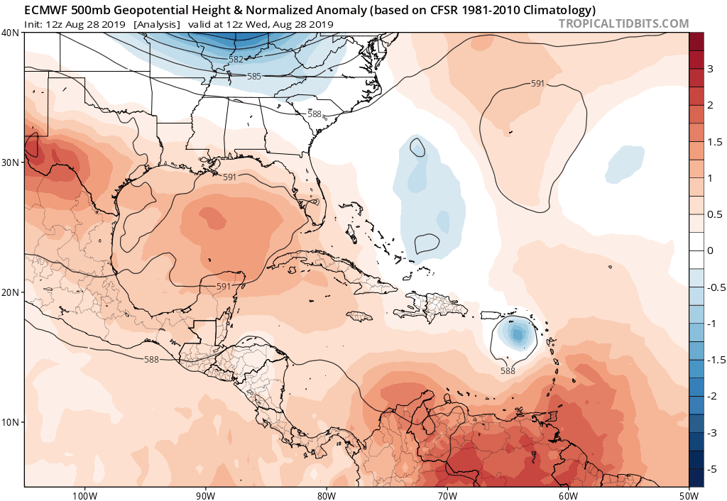
This complicates matters further for Florida with landfall delayed and then moving very slowly once inland as steering currents collapse. All the weather models seem to show this scenario.This map shows the European’s view of Dorian delaying landfall until Tuesday morning. The landfall is along the south Florida coast, and then it takes 3 days to move 300 miles. Such an outcome would mean feet of rain as well as a long duration event of tropica storm conditions. This clearly is one models view but it shows how complex the steering pattern is over the Southeastern US. We will be addressing this on our our live stream tonight on youtube at 7pm Eastern time as well as on our subscription weather platform on Patreon.
MANY THANKS TO TROPICAL TIDBITS FOR THE USE OF MAPS
Please note that with regards to any tropical storms or hurricanes, should a storm be threatening, please consult your local National Weather Service office or your local government officials about what action you should be taking to protect life and property.


