Ophelia Sets Sights On Western Europe
SHOP THE JOESTRADAMUS STORE
Ophelia Sets Sights On Western Europe
It isn’t very often that we pay attention to what is going on across the pond but it is rather interesting that we have soon to be Hurricane Ophelia in the Eastern Atlantic and you can see it about 1000 miles east of the Canary Islands. It is very small when you look at it from the perspective of this satellite view. But it is much closer to Western Europe than it is the United States. Tropical Storms and hurricanes occasionally do make it up to Western Europe particularly the British Isles. Most of the time they become strong or even fierce post tropical systems and there is a rather lengthy list of storms that have impacted Britian Ireland and nearby. In 2005 Hurricane Vince became the first storm in modern history that is known to have made landfall in Spain. Now we have Ophelia and an upper air pattern that will bring it very close to the coasts of Spain and France and then possibly into the British Isles early next week.
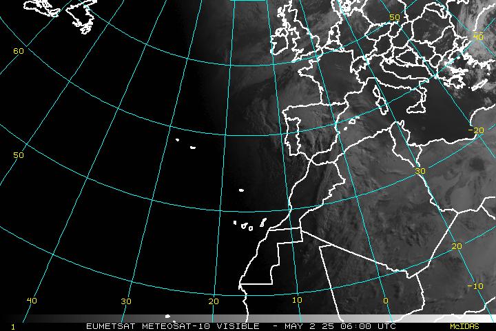
As of this morning on the tight satellite loop you can see Ophelia getting better orgnaized and actually drifting southward. Ophelia looks like it is strengthening and is likely to become a hurricane later today or tonight.

The National Hurricane Center’s forecast is for Ophelia to eventually begin moving to the northeast and by day 5 it will be offshore the coast of Spain.

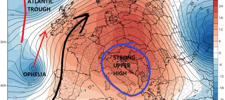
From here the upper air pattern would suggest a turn toward the north over time as Ophelia begins to interact with a strong non tropical low in the North Atlantic and a very strong upper high that is over Western Europe.
EUROPEAN UPPER AIR FORECAST FOR WESTERN EUROPE SUNDAY NIGHT

The forecast issue will be whether Ophelia maintains a separate identity as it moves northward or does it get absorbed by all the energy running aroung in the North Atlantic. Models have shifted westward overnight to suggest a near miss for Western Europe and the British Isles. Of course the margin of error is large since we are looking out in the day 6 and 7 time frame.
MANY THANKS TO TROPICAL TIDBITS FOR THE WONDERFUL USE OF THE MAPS
 GET JOE A CIGAR IF YOU LIKE

SHOP THE JOESTRADAMUS STORE
Weather App

Don’t be without Meteorologist Joe Cioffi’s weather app. It is really a meteorologist app because you get my forecasts and my analysis and not some automated computer generated forecast based on the GFS model. This is why your app forecast changes every 6 hours. It is model driven with no human input at all. It gives you an icon, a temperature and no insight whatsoever.
It is a complete weather app to suit your forecast needs. All the weather information you need is right on your phone. Android or I-phone, use it to keep track of all the latest weather information and forecasts. This weather app is also free of advertising so you don’t have to worry about security issues with your device. An accurate forecast and no worries that your device is being compromised.
Use it in conjunction with my website and my facebook and twitter and you have complete weather coverage of all the latest weather and the long range outlook. The website has been redone and upgraded. Its easy to use and everything is archived so you can see how well Joe does or doesn’t do when it comes to forecasts and outlooks.
Just click on the google play button or the apple store button on the sidebar for my app which is on My Weather Concierge. Download the app for free. Subscribe to my forecasts on an ad free environment for just 99 cents a month.
Get my forecasts in the palm of your hand for less than the cost of a cup of Joe!