Ophelia Category 3 Major Hurricane Ireland Bound
SHOP THE JOESTRADAMUS STORE
Ophelia Category 3 Major Hurricane Ireland Bound
Hurricane Ophelia becomes the seasons 6th major hurricane as it passes south of the Azores this morning with 115 mph winds. Then next stop for Ophelia will be the British Isles specifically Ireland as weather models are all in agreement that Ophelia will move directly over Ireland as a powerful extratropical storm with hurricane force winds on Monday.

…OPHELIA BECOMES A RARE CATEGORY 3 HURRICANE SOUTH OF THE
AZORES…
…THIS IS THE SIXTH MAJOR HURRICANE OF THE 2017 SEASON…
SUMMARY OF 1100 AM AST…1500 UTC…INFORMATION
———————————————–
LOCATION…34.8N 26.6W
ABOUT 220 MI…355 KM S OF THE AZORES
MAXIMUM SUSTAINED WINDS…115 MPH…185 KM/H
PRESENT MOVEMENT…NE OR 55 DEGREES AT 25 MPH…41 KM/H
MINIMUM CENTRAL PRESSURE…960 MB…28.35 INCHES
WATCHES AND WARNINGS
——————–
There are no coastal tropical cyclone watches or warnings in effect.
Interests in the Azores should refer to products issued by the
Azores Weather Forecast and Watch Center.
Interests in Ireland should monitor products issued by Met Eireann,
and interests in the United Kingdom should monitor products issued
by the UK Met Office.
DISCUSSION AND 48-HOUR OUTLOOK
——————————
At 1100 AM AST (1500 UTC), the distinct eye of Hurricane Ophelia was
located near latitude 34.8 North, longitude 26.6 West. Ophelia is
moving toward the northeast near 25 mph (41 km/h), and this motion
is expected continue through Sunday with a turn toward the
north-northeast thereafter. On the forecast track, the core of
Ophelia will pass to the south and southeast of the southeastern
Azores by tonight.
Satellite data indicate that the maximum sustained winds have
increased near 115 mph (185 km/h) with higher gusts. Ophelia is a
category 3 hurricane on the Saffir-Simpson Hurricane Wind Scale.
No significant change in strength is expected today, but gradual
weakening should begin tonight or Sunday. However, Ophelia is still
expected to remain a powerful cyclone with hurricane force winds for
the next couple of days as it approaches Ireland.
Hurricane-force winds extend outward up to 45 miles (75 km) from the
center and tropical-storm-force winds extend outward up to 125 miles
(205 km).
The estimated minimum central pressure is 960 mb (28.35 inches).
HAZARDS AFFECTING LAND
———————-
WIND: Tropical-storm-force winds are possible throughout the Azores
beginning this afternoon or tonight, primarily due to an approaching
cold front.
RAINFALL: Ophelia is expected to produce total rain accumulations
of 1 to 3 inches over the central and southeastern Azores through
Saturday night.
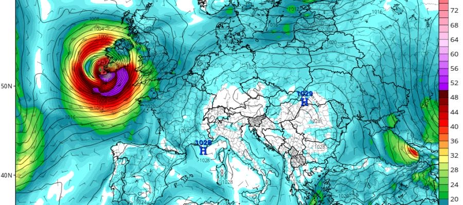
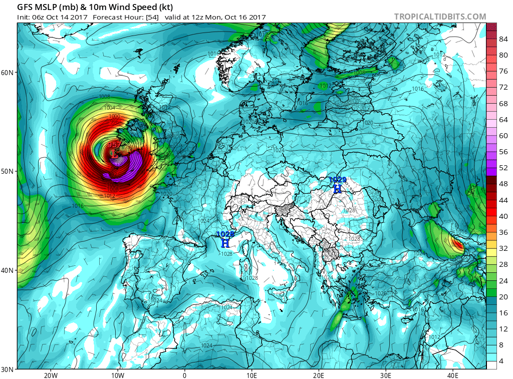
GFS MODEL OPHELIA HITTING IRELAND NOON MONDAY WIND FORECAST
CANADIAN MODEL OPHELIA HITTING IRELAND NOON MONDAY WIND FORECAST
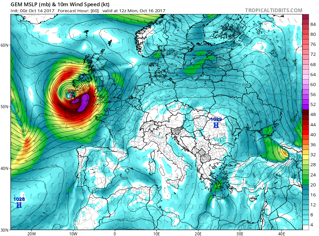
The maps above are the GFS & Canadian model showing Ophelia coming ashore as a powerful non tropical cyclone along the south coast of Ireland with a large are of 50 knot or higher sustained winds. Combine that with the foward speed of 20-30 mph and there will be wind gusts in excess of hurricane force. The storm will then spread its wind across England particularly Northern England and Scotland though it may weaken after crossing Ireland. This has been an amazing hurricane season meteorologically and it continues to astound.
MANY THANKS TO TROPICAL TIDBITS FOR THE WONDERFUL USE OF THE MAPS
 GET JOE A CIGAR IF YOU LIKE

SHOP THE JOESTRADAMUS STORE
Weather App

Don’t be without Meteorologist Joe Cioffi’s weather app. It is really a meteorologist app because you get my forecasts and my analysis and not some automated computer generated forecast based on the GFS model. This is why your app forecast changes every 6 hours. It is model driven with no human input at all. It gives you an icon, a temperature and no insight whatsoever.
It is a complete weather app to suit your forecast needs. All the weather information you need is right on your phone. Android or I-phone, use it to keep track of all the latest weather information and forecasts. This weather app is also free of advertising so you don’t have to worry about security issues with your device. An accurate forecast and no worries that your device is being compromised.
Use it in conjunction with my website and my facebook and twitter and you have complete weather coverage of all the latest weather and the long range outlook. The website has been redone and upgraded. Its easy to use and everything is archived so you can see how well Joe does or doesn’t do when it comes to forecasts and outlooks.
Just click on the google play button or the apple store button on the sidebar for my app which is on My Weather Concierge. Download the app for free. Subscribe to my forecasts on an ad free environment for just 99 cents a month.
Get my forecasts in the palm of your hand for less than the cost of a cup of Joe!