DOWNLOAD MY NEW FREE JOESTRADAMUS WEATHER APP FOR ANDROID
THE APP IS ABSOLUTELY FREE TO ALL BUT CONSIDERING SUBSCRIBING TO PATREON FOR A WEATHER EXPERIENCE FREE OF ADS, EXCLUSIVE VIDEOS FOR MEMBERS ONLY AND MUCH MORE…STARTS AT $2 A MONTH..MESSAGE ME AT ANY TIME
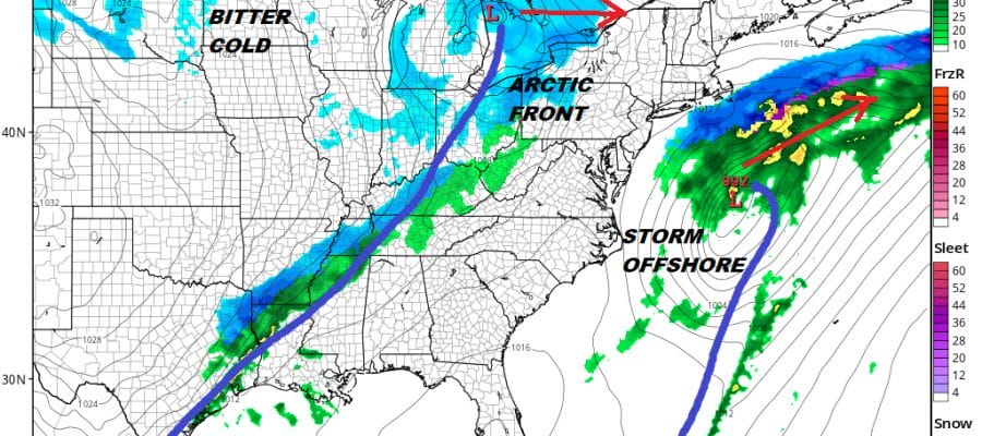
Ocean Storm East Arctic Front West Stuck In Between
While our weather is calm and seasonal for the last weekend of January, there is action going on to the east and to the west of us. Over the next two days a storm that will be developing off the Florida coast will be heading northeastward offshore. Weather models have been inching westward with this feature but it is still too far offshore to even consider it a close shave. While we tend to focus time on the conditions in the Pacific and its impact here, the Atlantic is in a pattern that is not favorable for storms to come up the east coast close enough to be an issue.
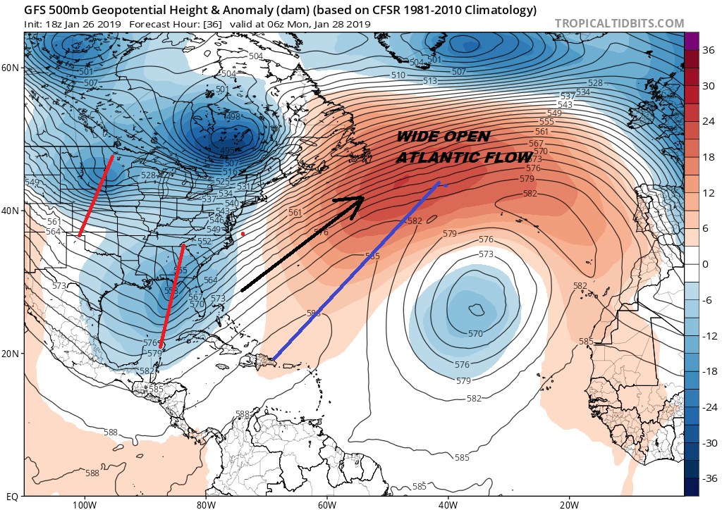
As the Pacific is often a mess with a screaming west to east jet stream from Asia to the West Coast, the Atlantic is in a mess as well. The flow is screaming with a southwest jet from Florida to nearly 3/4’s of the way across. With no storms to the east of this feature, the path is clear out to sea. Meanwhile to the west shortwaves that are going to swing the Arctic front through here are loading up and ready to make their moves on the Eastern US.
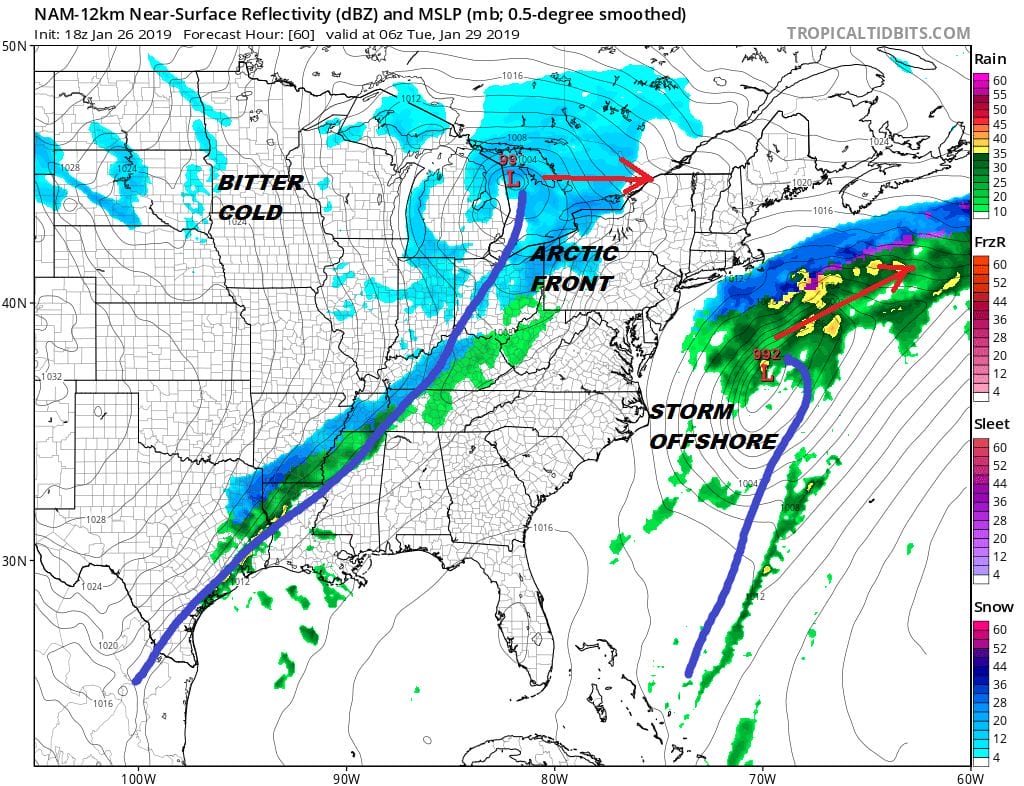
The NAM model from earlier showed a rather over developed gale offshore and new model runs are not as deep and further south. It matters little to us either way. Now we watch the arctic front to the west as it approaches. We are stuck in between the two for the next 2 days so our weather is calm and quiet. Sunday should be a little warmer on the temperatures as we reach into the 40s and then it will turn a little colder for Monday with highs just in the 30s. Other than patchy clouds and a few snow showers showing up on the regional radar upstate weather conditions are quiet for the overnight with mainly clear skies with just a few passing clouds with lows in the 20s and not much wind.
EASTERN SATELLITE

REGIONAL RADAR

Jumping ahead now to Tuesday we will look for arriving clouds with highs into the 40s and some rain showers developing later in the day into the evening until the front begins to pass through. There will be some post frontal precipitation and rain should change over to a period of snow once it passes. This is not the sort of situation that produces big snowfalls here unless a wave develops on the front as it goes by and takes a perfect track.
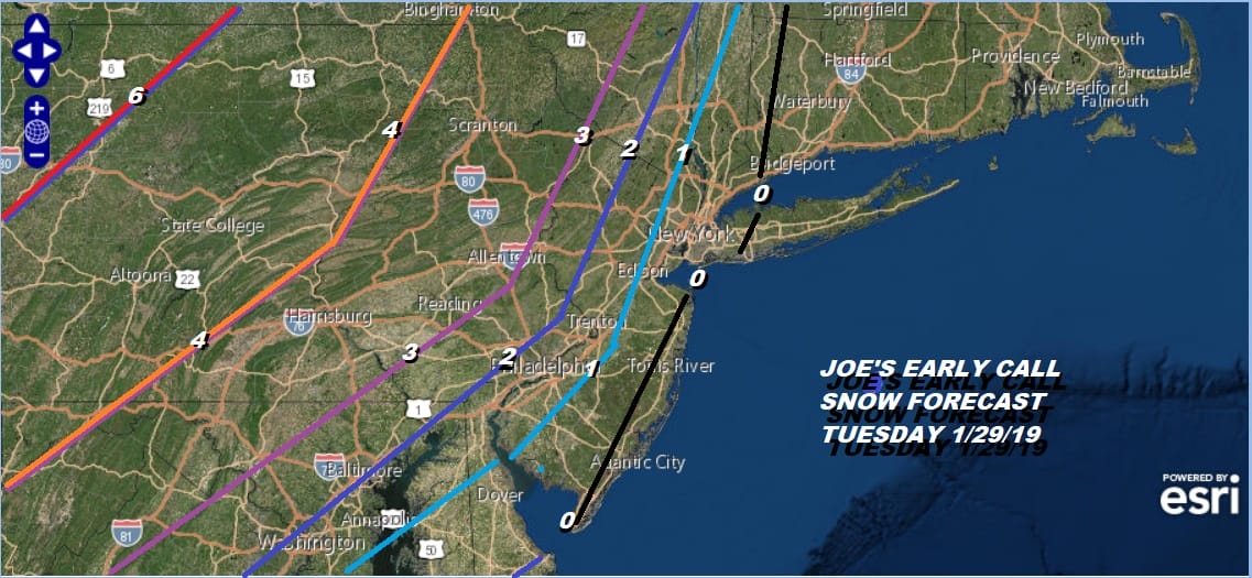
The front looks almost like a stick with a band of snow on the western side. This has the chance to leave a coating to a few inches of accumulation from just west of NYC westward with higher amounts across Pennsylvania southward into Western Maryland and Northwest Virginia. Right now little or nothing along the immediate coast with this. These numbers could be easily cut in half across New Jersey and the zero line could wind up being where the 1″ or 2″ line is now. Expect this map to move around a bit in the next few days. Arctic air arrives behind this and temperatures on Wednesday will settle in the 20s and then they will be at the coldest Thursday morning when most lows should be in the single digits to near 10 and highs Thursday will be in the teens to near 20.
MANY THANKS TO TROPICAL TIDBITS FOR THE USE OF MAPS
Please note that with regards to any tropical storms or hurricanes, should a storm be threatening, please consult your local National Weather Service office or your local government officials about what action you should be taking to protect life and property.


