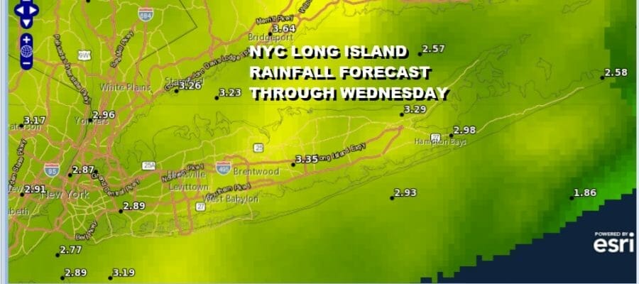
NYC Long Island Flash Flood Watch Rainfall Forecast Tonight Into Wednesday
Flash Flood Watches are up tonight for much of Eastern Pennsylvania to Southeastern New England. This includes Long Island & NYC. A cold front is sinking southward and rain will overspread the area this evening and tonight. The key to the high rainfall forecast amounts being achieved is the develoment of a slow moving wave on the frontal boundary. This will create an enviornment of a loaded radar and a slow moving area of steady rain with heavy downpours overnight and during the day Tuesday.

Rain will start to taper off to the west late Tuesday and we will see it continue along the coast Tuesday night and then taper off on Long Island Wednesday morning. 2 to 3 inches of rain seems doable with some locally higher amounts. This is the first widespread rainfall we have seen for several months.

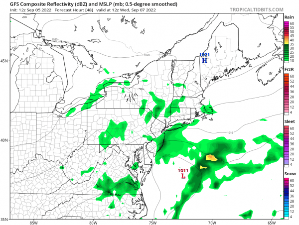
By Wednesday morning as the GFS shows there will be a wave offshore with an east wind. The steady rains will end but there will still be some leftover patches of rain and drizzle. Eventually the wave will exit and we should start to see better weather conditions developing from west to east Wednesday night and Thursday. At least the end of the week finishes dry. While it is raining temperatures will likely settle into the mid 60s to lower 70s. The remainder of the week will see highs in the 70s to near 80 Thursday and upper 70s and lower 80s Friday.
BE SURE TO DOWNLOAD THE FREE METEOROLOGIST JOE CIOFFI WEATHER APP &
ANGRY BEN’S FREE WEATHER APP “THE ANGRY WEATHERMAN!
MANY THANKS TO TROPICAL TIDBITS & F5 WEATHER FOR THE USE OF MAPS
Please note that with regards to any severe weather, tropical storms, or hurricanes, should a storm be threatening, please consult your local National Weather Service office or your local government officials about what action you should be taking to protect life and property.