
Noreaster threat and noreaster conditions are being indicated by the models this afternoon. There have been model adjustments in today’s runs across the board. I would like to wait one or 2 more runs to gain some confidence in this.
Noreaster But No Cold Air
In terms of the overall structure of the model runs this afternoon especially the European Model, there has been a subtle shift in the upper air structure in Canada. This increases the threat for a noreaster but it does not change the issue of a lack of cold air much.
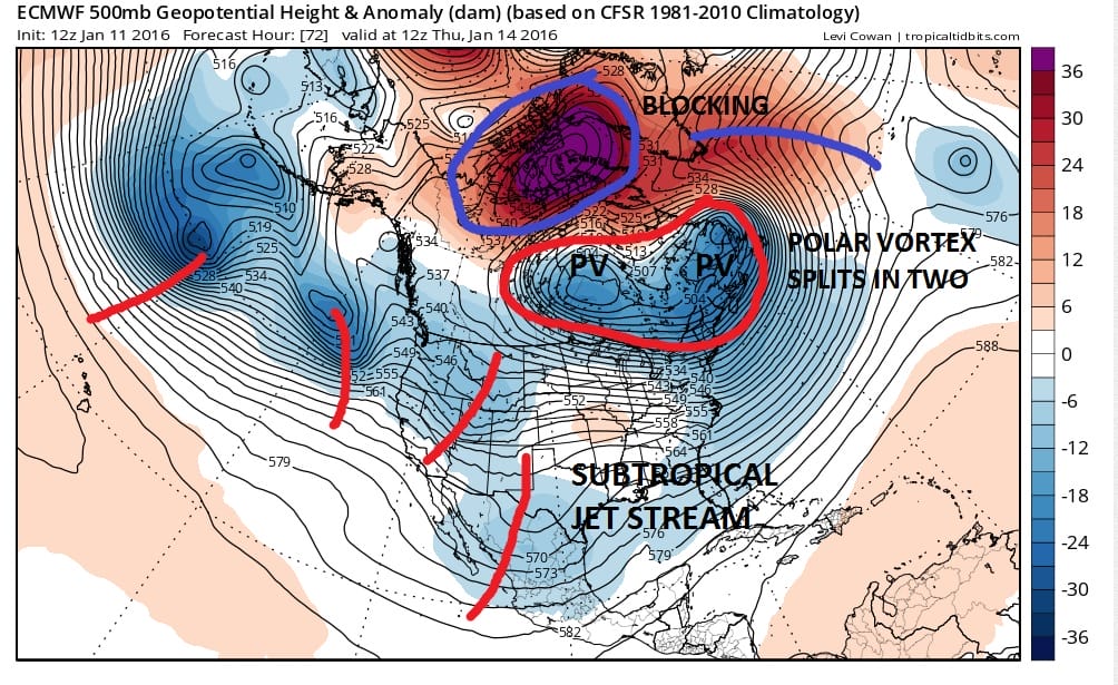 We discussed yesterday how we have blocking but we also have the polar vortex splitting across Southern Canada. Yesterday’s and last night’s model runs were showing the split occurring and the southern stream energy phasing around the new vortex to the west. This cuts off the cold air from getting back into the northeast and it forces the surface low to cut west. You probably sensed my frustration in all this model gyrations last night in my weather video. Today’s models have shifted in small but important ways which shift the development away from the primary low and force more of the energy to a secondary low to develop off the coast. What seems to be happening is that the new vortex is taking a little longer in establishing an ideal position to take the southern system and turn it north. This delay allows the southern energy to move along a little further east before beginning its turn northeastward. So instead of taking a primary low to the Western Great Lakes, we wind up with a low that goes to Saint Louis to the Ohio Valley before redeveloping. The European and the UK models are bullish in developing a coastal off New Jersey by Saturday morning.
 The entire structure of the upper trough across the Eastern United States is much broader than earlier forecast, which if true, allows for a further south track of the primary and a more robust secondary development which is what the European model does. Even the GFS does this too but it seems to still want to hold on to a more northward bias.
 However for snow lovers along the coast there remains a huge problem. For one the European for all the secondary development holds onto the primary low which is near Buffalo. Eventually that primary disappears and the secondary takes over. The second issue is that the polar vortex split cuts off cold air from building back into the Eastern states with any importance. While the European would certainly suggest there could be some snow at the start in Northwest New Jersey, the Hudson Valley, and Connecticut, the coast would be mainly rain and inland areas would go over to rain. Central and Northern New England and upstate New York would stay mostly snow in a case like this. Actually interior Central and Northern New England could do quite well. The cold air that will be over us Wednesday and Thursday pulls out Friday. While the models try to drain some cold air back southward later Friday evening ahead of all this, it is not going to be enough based on this run to save coastal areas of Southern New England and points southward.
The one way this becomes something more important from a snow standpoint is if the vortex that splits and forms west is less deep and the vortex on the east side over Southeastern Canada is stronger and slower in getting out of the way. That might make it a little colder. Still the models do suggest noreaster Conditions Friday night and Saturday for the coast with rain, wind and higher than normal tides.
Here is my overnight GFS model analysis
NATIONAL WEATHER SERVICE SNOW FORECASTS
LATEST JOESTRADAMUS ON THE LONG RANGE
Weather App

Winter is here! Don’t be without Meteorologist Joe Cioffi’s weather app. It is a complete weather app to suit your forecast needs. All the weather information you need is right on your phone. Android or I-phone, use it to keep track of all the latest weather information and forecasts. This weather app is also free of advertising so you don’t have to worry about security issues with your device. An accurate forecast and no worries that your device is being compromised.
Use it in conjunction with my website and my facebook and twitterand you have complete weather coverage of all the latest weather and the long range outlook. The website has been redone and upgraded. Its easy to use and everything is archived so you can see how well Joe does or doesn’t do when it comes to forecasts and outlooks.
Just click on the google play button or the apple store button on the sidebar for my app which is onMy Weather Concierge. Download the app for free. Subscribe to my forecasts on an ad free environment for just 99 cents a month.
Get my forecasts in the palm of your hand for less than the cost of a cup of Joe!
![]()