ONE DAY OF “WARMTH” WITH SOME SUN TODAY
COLD AIR BUILDS IN WEDNESDAY-SATURDAY
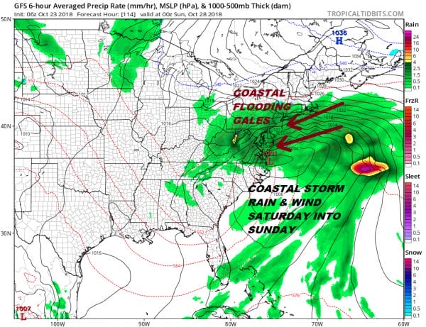
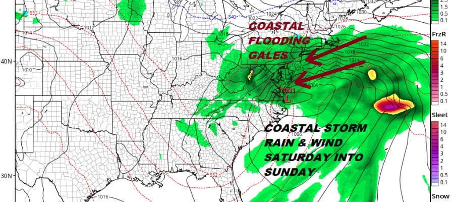
COASTAL STORM GROWS MORE LIKELY SATURDAY
Today is our one warm day this week and by “warm” we only mean temperatures getting back close to average for this time of year. The overall pattern remains chilly and it is being driven by a building blocking high in the North Atlantic and another deep upper trough in the Eastern US. The flow aloft is coming straight out of Northern Canada and that will drive temperatures 10 to 15 degrees below average Wednesday through the weekend. Highs will reach into the 60s today. The front comes through and there is an outside chance for a brief shower. The chance is very low and 99 percent of the area won’t see one. Then skies clear out tonight with lows in the upper 30s and lower 40s
EASTERN SATELLITE
REGIONAL RADAR
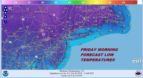
Wednesday look for sunshine and some clouds with a gusty breeze at times and highs just into the 50s. High pressure builds down from the Great Lakes and Southeastern Canada which will lead to cold conditions Thursday and Friday. Highs both days just in the 40s to near 50. Friday morning will bring a widespread freeze and even the warmer urban areas which have been the last to hold up above freezing could finally capitulate.
COASTAL STORM THREAT GROWS FOR THE WEEKEND
We have been watching the evolution of a deep upper trough in the Eastern US and the impact of low pressure coming out of the Gulf States. That low will also carry some of the remnants of Hurricane Willa which is making landfall along the west coast of Mexico today. That low turns up the coast Friday night with increasing clouds. Saturday as the low moves northward rain overspreads the area from south to north and winds along the coast will be increasing from the Northeast to gale force.

Weather models are all rather tightly clustered though the European is a little faster and has the rain moving in during the early morning hours on Saturday. This is important from the standpoint of coastal flooding. Tomorrow night we have a full moon and peak high tides are Friday but tides will still be running high Saturday. Coastal flooding is going to occur from Southern New England to Chesapeake Bay. Rainfall amounts of up to a couple of inches seem like a pretty good bet here. If everything moves along we could actually see improving weather conditions on Sunday as the low moves to the north. With the northeast winds and the cold high to the north temperatures on Saturday will be in the low to mid 40s all day while it is raining. Sunday we should be back into the 50s assuming the faster models are correct and weather conditions improve. We will be looking at this with greater detail later today.
SUBSCRIBE TO PATREON FOR A WEATHER EXPERIENCE FREE OF ADS, EXCLUSIVE VIDEOS FOR MEMBERS ONLY AND MUCH MORE…STARTS AT $2 A MONTH..MESSAGE ME AT ANY TIME
MANY THANKS TO TROPICAL TIDBITS FOR THE USE OF MAPS
Please note that with regards to any tropical storms or hurricanes, should a storm be threatening, please consult your local National Weather Service office or your local government officials about what action you should be taking to protect life and property.
LATEST JOESTRADAMUS ON THE LONG RANGE


