Noreaster Possibility Cold Air Lacking
Noreaster Possibility Cold Air Lacking
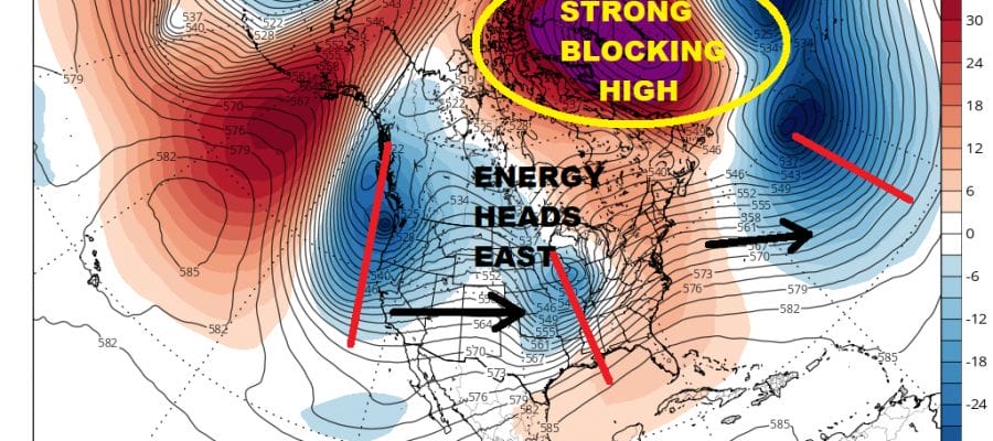
We continue to watch weather models evolve for next week as a very strong blocking upper high makes its way across Greenland and into Northeastern Canada. The result is a displacement of the jet stream well to the south of normal and it opens the door to the possibility of a noreaster along the Middle Atlantic coast late next week. However just because we have a noreaster possibility doesn’t necessarily mean it will come with snow. It may come with mostly rain and some wind and coastal flooding. All of this hinges on the strength of the block, where it builds strongly, and how far south energy from the west tracks as it heads to the East Coast.

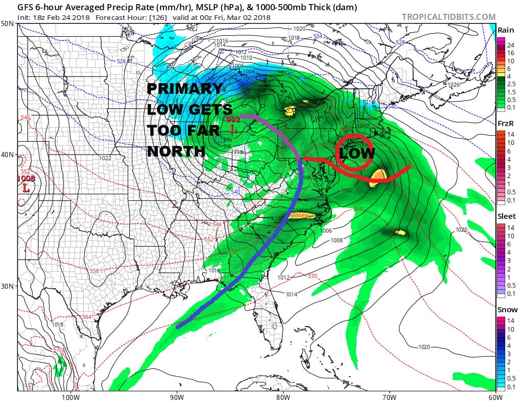
The big issue here on Thursday as the GFS shows (as the other models show as well) is the position of the upper high. At this point it is still too far to the north but building southwestward. The energy that is heading east into the Middle Mississippi Valley wants to head northeast to the Great Lakes. It will do so until the block forces that energy eastward. The forecast problem here is that the primary surface low heads a little too far north.
GFS FORECAST THURSDAY NIGHT MARCH 1 2018
The GFS shows this quite well and other models are not that different. A secondary low will develop and take over very quickly but it is too far to the north on this run as well. The low eventually drops southward but again a set up like this would mean no cold air of importance in our area. What could change things a bit is if the blocking high develops stronger and makes its way further south. The GFS ensembles suggest this is possible as it has most of its members showing tracks further south.
GFS ENSEMBLES FRIDAY 7AM FRIDAY MARCH 2, 2018

A track further south would allow the strong upper air dynamics to create some of what I call “do it yourself cold air” which is basically cold air that is produced by the intensifying cyclone. But this would require a lot of things to come together and at the moment I would rate this a bit of a long shot. Regardless it seems that we are at least in line for some wind, rain, and coastal flooding. A full moon is going to occur at the end of next week so a noreaster at this time offshore would create abnormally high tides for a few days. This system may linger awhile offshore. It could set the stage for another system several days later but it is way too soon to even speculate on that one when the first one needs to play out first.
SHOP THE JOESTRADAMUS STORE
MANY THANKS TO TROPICAL TIDBITS FOR THE WONDERFUL USE OF THE MAPS

GET JOE A CIGAR IF YOU LIKE!
FiOS1 News Weather Forecast For Long Island
FiOS1 News Weather Forecast For New Jersey
FiOS1 News Weather Forecast For Hudson Valley
NATIONAL WEATHER SERVICE SNOW FORECASTS
LATEST JOESTRADAMUS ON THE LONG RANGE