
Overnight models are pretty consistent. Some runs cut back..some add rainfall. The thing that i noticed in the early morning update run was that the front approaches faster and then slows down along the coast with a little wave that develops on it. This prolongs the rain along the immediate coast for another 3 to 6 hours which could make a nice added difference to the rainfall amounts.

You can see the beginnings of this at 2pm Tuesday as the isobars (lines of equal pressure) begin to stretch south southwestward. It doesn’t take much to slow things down. Notice that for the period ending 8pm there is precip all over the place again so it stands to reason that we will get a shot of downpours..then a break…followed by another shot in the afternoon and tomorrow evening. If we can get a few heavy downpours to sit around awhile we could cut the rainfall deficit in half which would be great.
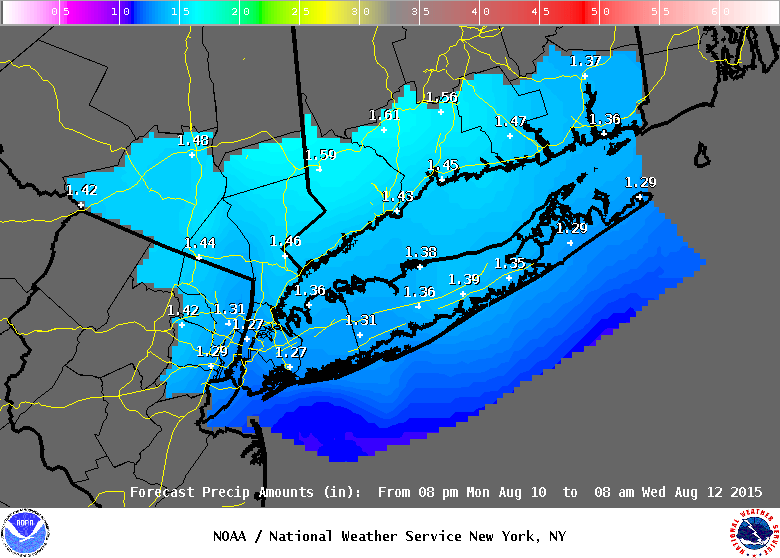
 The weather service is forecasting 1 to 2 inch rainfall for the New York/Northern New Jersey/Southern Connecticut zones which is in line with what I’m seeing. I’m betting on some local amounts over 2 inches out of this.
 Wednesday through Friday continue to look good with sunshine and highs in the lower 80s except that by Friday it will turn very warm with highs well into the 80s.
BE READY FOR THE HEAVY RAINS…DOWNLOAD MY WEATHER APP!!! APP IS FREE! SUBSCRIBE FOR JUST A BUCK! THE APP IS COMPLETELY FREE OF ADVERTISING AND THERE ARE NO SECURITY ISSUES
 Meteorologist Joe Cioffi Weather updates is a complete weather website. You will find weather updates, weather news, weather radar, my weather app, snow forecasts, severe weather, hurricanes and other tropical weather, current conditions, long range with Joestradamus and his 10 day forecast outlook and videos from my weather broadcasts on WPIX-TV and FiOS1 News.
Take a look around. Weather radars from various locations are real time and link to the National Weather Service. On each of the local pages you will find scrolling rss feeds in real time with all National Weather Service advisories, watches, and warnings. During the winter months there are 2 snowstorm pages to keep handy. The first is the snowforecasts page which has the latest National Weather Service updated snowfall forecast maps which update in real time. The second is my joesnowforecasts page which has my forecast maps and discussion on what to expect. For short range weather outlooks I have 3 pages.Joesforecast which takes the short term view including week ahead and weekend outlooks. 2 other pages tackle the models and what they have to tell us. The GFS and the popular European model which has a strong performance record overall especially when it comes to east coast winter storms. Current
Many of you are interested in the long range 10 weather forecast outlook and myJOESTRADAMUS page previews the weather down the road and the overall weather pattern. For mariners and fisherman and women, my marine forecast page has tides and tide heights, winds and the latest advisories and warnings from the National Weather Service on real time scrolling RSS feeds.
Finally there is my weather app which put me right on your phone with the latest forecasts for New York, New Jersey, Connecticut, Eastern Pennsylvania, Hudson Valley, and Long Island. This way you can carry me around everywhere. My weather is also available on facebookand on twitter.


