New Years Eve Dry New Years Day Rain Freezing Rain Arrive Late Sunday Coastal Low Possible

Weather in 5/Joe & Joe Weather Show Latest Podcast
New Years Eve Dry New Years Day Rain Freezing Rain Arrive Late Sunday Coastal Low Possible
We have a nice day ahead overall but there is a band of clouds moving quickly east this morning as the tail end of a warm front that is well to our northwest. This you can see it on the satellite picture this morning but once that goes by we should go partly to mostly sunny. There are some snow showers in that band of clouds and they should dry up as they move east but don’t be surprised if you see a few flakes flying around this morning.
SATELLITE

That band of snow is showing up on both views of the regional radars of New England and the Middle Atlantic states. It is moving fast and it won’t amount to much as it goes by. The rest of the day should see quiet radars. Temperatures this afternoon will reach the upper 30s to some lower 40s.


Look for temperatures to not go very far tonight as a cold front approaches. We may actually see them inch into the 40 ahead of the front which will pass through Thursday morning with a few showers. Once that goes by weather conditions improve by afternoon with temperatures probably holding in the upper 30s and lower 40s. Then under mainly clear skies Thursday night, we will see lows down in the 20s to lower 30s with many areas going back below the freezing mark.
We have seen the high building in for Thursday into Friday morning become stronger over the last few days slowing down the arrival of precipitation. What started days ago looking like a complete repeat of Christmas Eve and Christmas Day has evolved into something completely different. Low pressure is now headed well to the west and we have Thursday’s cold front stalling to the south and coming back up as a warm front.
Friday will see increasing clouds from south to north. There is low level cold air that will get trapped inland while warm air overrides it aloft. Rain develops later in the afternoon and evening from south to north and inland we are looking at freezing rain at least for a few hours.

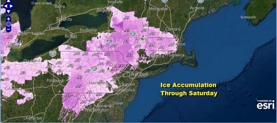
The map above is the Ice Accumulation forecast from NWS through 7am Saturday AM.so we do have some additional icing to add to this during Friday night. The areas of icing risk are inland generally north of Route 76 in Pennsylvania, In New Jersey north of Route 78 and west of Route 287, in the Hudson Valley we are talking mainly north of Route 84 but there could be some light icing south to Route 287. In Connecticut the risk is Friday night and it should be along and north of Route 84 though some icing could extend south to Route 15. For every where else it is rain that will exit by Saturday morning temperatures will hold steady inland in the 30s and rise along the coast into the 40s. The warm front will be stubborn to get through. Saturday should see some improvement with left over clouds with a cold front moving offshore. Highs Saturday will be in the 40s to around 50 and it could be higher if the sun comes out.

The cold front that comes through Saturday stalls out and low pressure develops on it and heads northward to just offshore Sunday night into Monday. While the GFS keeps it barely offshore it is further northwest of prior runs and the other models have this much more of a threat. Some colder air comes back on Sunday but unless the storm were to intensify into something major (not likely), the coast will see rain but inland areas north, northwest and northeast of NYC could see some wet snow out of this. This would be for later Sunday into early Monday. We will discuss this further later today on out Weather in 5 video.
BE SURE TO DOWNLOAD THE FREE METEOROLOGIST JOE CIOFFI WEATHER APP &
ANGRY BEN’S FREE WEATHER APP “THE ANGRY WEATHERMAN!
MANY THANKS TO TROPICAL TIDBITS FOR THE USE OF MAPS
Please note that with regards to any severe weather, tropical storms, or hurricanes, should a storm be threatening, please consult your local National Weather Service office or your local government officials about what action you should be taking to protect life and property.


