New Year System Rain Freezing Rain Possible Well Inland Not As Potent As Christmas Storm

Weather in 5/Joe & Joe Weather Show Latest Podcast
New Year System Rain Freezing Rain Possible Well Inland Not As Potent As Christmas Storm
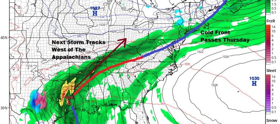
The last days of 2020 are finally here and the main event this week will be a storm system for later New Year’s Eve and New Years Day. The profile of this storm has changed over the last few days. At first glance this looked like it was going to be a repeat performance of the Christmas Eve and Day storm with another round of very strong winds and heavy rains. Now it seems that we will see something much different with a low going up west of the Appalachians. This will play out differently for sure. Meanwhile today we have a cold front approaching to usher in the next round of changes.
SATELLITE

The satellite picture this morning is showing lots of clouds and the regional radars below are picking up on rain and snow to the west. However the vast majority of this if not all it will pass west and north of the coastal plain, leaving us in cloud today with some breaks of sunshine and highs in the 40s.


The cold front moves offshore and we begin the next round of changes tonight as skies clear and it turns colder again. Lows will be in the mid 20s to lower 30s from inland to urban and coastal areas. Tuesday we will see some sunshine with highs in the 30s and then down to the teens and low 20s Wednesday morning. Wednesday looks like a nice day with sunshine most of the day with highs in the 30s to around 40 or so.

Thursday New Years Eve we start to look west and south. Unlike Christmas Eve where we had a screaming southerly flow that developed ahead of a strong cold front and a big high to the east, this time around we will have a cold front move through here first on Thursday with one or two showers as it goes by. This should be no big deal. The front will stall to our south and then a strong low coming out of the Gulf States takes a track northeastward and goes west of the Appalachians.

We will have very warm air aloft but the low levels of the atmosphere will see colder air bleed southward from a high moving across Upstate NY and into Maine. This could put some inland areas at risk for freezing rain Thursday night into Friday morning as the GFS model shows along with other models. Thursday could see temperatures reach the 50s before the cold front passes and then drop into the 30s at night and mid to upper 20s inland.
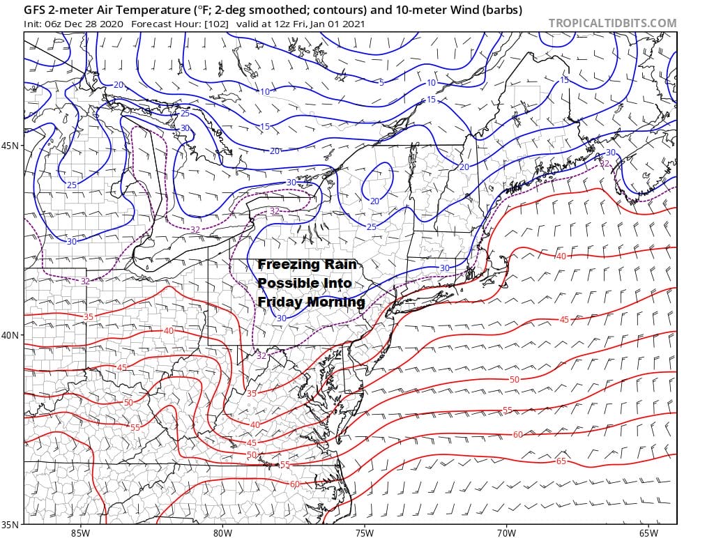
Rain is going to be moving back northward Thursday night into Friday morning into that area of below 32 degree temperatures (shown by the dash purple line) The freezing line stays north and west of the I-95 corridor and the big cities but it could be an issue at least for several hours inland. Then it is always a struggle in these situations whether the low continues to move northeastward and whether the warm front gets through our area or gets hung up somewhere. This still has to be worked out but we will see a steady rain New Years Day into Friday night. Temperatures will depend on the warm front, 30s and low 40s to the north of it and 50s to the south. We will just have to try to figure out where.

The first weekend of 2020 looks to be dry and chilly behind tis storm but the air behind it isnt all that cold. Also we will see the southern part of the cold front stall out in the Eastern Gulf of Mexico where another wave develops on it moves northeastward along the Southeast coast. It gets ejected eastward but this looks like it might be a situation for a closer call precipitation wise. That would be for Sunday night or Monday of next week. We will examine this prospect later today in the long range.
BE SURE TO DOWNLOAD THE FREE METEOROLOGIST JOE CIOFFI WEATHER APP &
ANGRY BEN’S FREE WEATHER APP “THE ANGRY WEATHERMAN!
MANY THANKS TO TROPICAL TIDBITS FOR THE USE OF MAPS
Please note that with regards to any severe weather, tropical storms, or hurricanes, should a storm be threatening, please consult your local National Weather Service office or your local government officials about what action you should be taking to protect life and property.


