NCEP Models Storm Signals Confusion

Overnight model runs are throwing all sorts of signals all over the place which really leads to all sorts of forecast confusion. Usually at this point it is wise from a forecast standpoint to take a step back and just watch things evolve rather than try to figure this out exactly. As we have mentioned in numerous long range posts lately that the volatility is high. It manifests itself with run to run swings with big storms on some runs and not on others. The best way to handle this is to just wait for some clear trend to emerge.
NCEP Models Storm Signals Confusion Long Range GFS & European
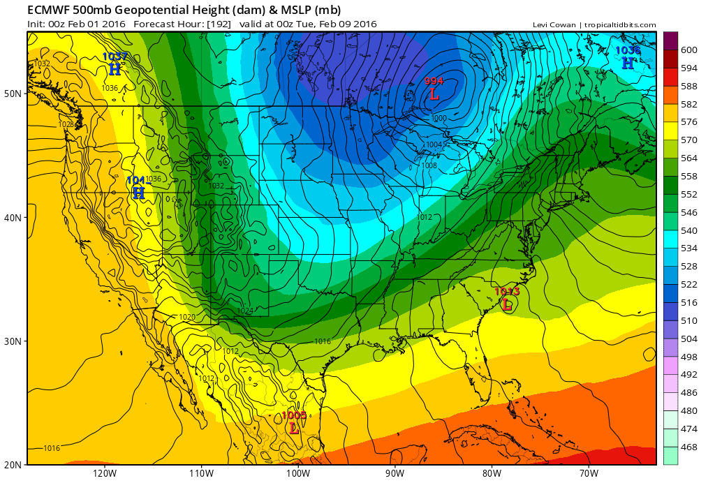
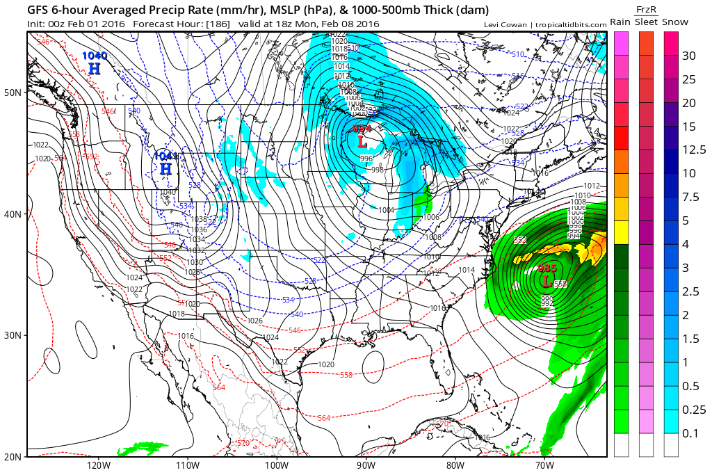

Here are the last 2 runs of the GFS and the last run of the European. All three models show a major storm on the map with the European also showing a major storm going up the Appalachians and into Eastern Canada. It is just a little slower in getting there but I has the idea. Now there are all sorts of upstream complications in the pattern and before we start going off the deep end, I think it is just better to sit an wait a bit there. Some variations of the European have the low more like the GFS. Cold air could be an issue for the coast given the lack of a high to the north and low pressure near Lake Huron which might favor more of a coast hugger. But I’m not going to lose sleep over this at the moment.
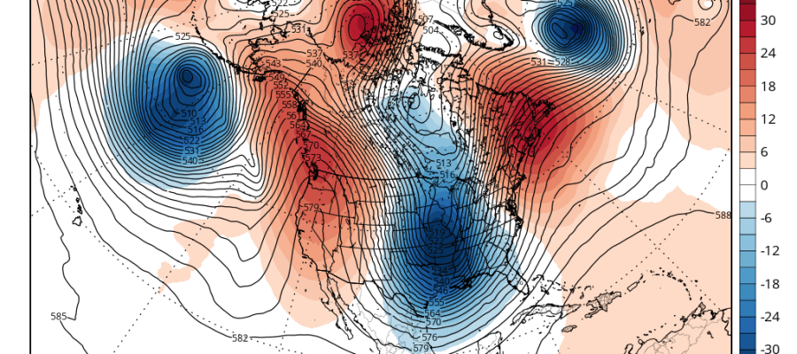
NCEP Models Storm Signals Confusion Upper Air Pattern European Day 9
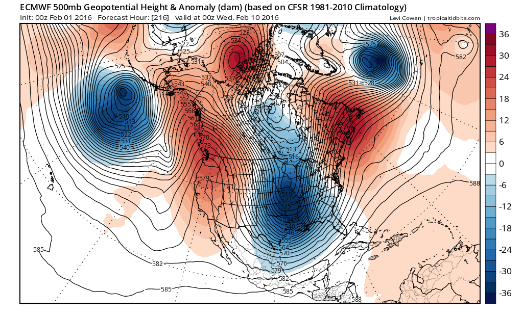
All the models show a very deep trough but we should point out that the trough position that is setting up on the European is along 90 west and that doesn’t not necessarily favor snow for the coast. But again don’t draw any conclusions yet from any of this at the moment. The pattern is dynamic and lots of things may still evolve out of all of this.
NATIONAL WEATHER SERVICE SNOW FORECASTS
LATEST JOESTRADAMUS ON THE LONG RANGE
Weather App

Winter is here! Don’t be without Meteorologist Joe Cioffi’s weather app. It is a complete weather app to suit your forecast needs. All the weather information you need is right on your phone. Android or I-phone, use it to keep track of all the latest weather information and forecasts. This weather app is also free of advertising so you don’t have to worry about security issues with your device. An accurate forecast and no worries that your device is being compromised.
Use it in conjunction with my website and my facebook and twitterand you have complete weather coverage of all the latest weather and the long range outlook. The website has been redone and upgraded. Its easy to use and everything is archived so you can see how well Joe does or doesn’t do when it comes to forecasts and outlooks.
Just click on the google play button or the apple store button on the sidebar for my app which is onMy Weather Concierge. Download the app for free. Subscribe to my forecasts on an ad free environment for just 99 cents a month.
Get my forecasts in the palm of your hand for less than the cost of a cup of Joe!

![]()