Nassau Northwest Suffolk Could See Upper 80s Wednesday,
Long Island Holiday Weekend Outlook

Weather in 5/Joe & Joe Weather Show Latest Podcast
Nassau Northwest Suffolk Could See Upper 80s Wednesday,
Long Island Holiday Weekend Outlook
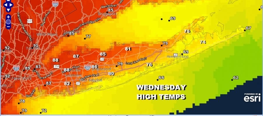
All in all it was a beautiful afternoon on Long Island with sunny skies, not much of a wind, low humidity, and temperatures in the 70s. Now we watch a warm front go by to our north, a wind shift to the southwest and then west southwest during the on Wednesday which will be boosting temperatures. Wind direction will be key to how warm it gets Wednesday. Initially I thought this would be an island wide day of highs reaching 90 or better but there is an issue with the wind direction the further east you go.

We shaved a few degrees off of earlier forecast highs. Nassau and at least the northwestern half of Suffolk County will see highs Wednesday in the mid to upper 80s. Low 80s for highs are forecast for the South Shore and mostly 70s inland on the East End. Dew points will rise into the 60s making for a humid day and then there is the chance for scattered thunderstorms in the evening. The Storm Prediction Center has much of Long Island outside the severe weather risk zone except for Nassau County into the corner of NW Suffolk County.
SATELLITE

Once the front goes by weather improves and Thursday looks good with sunshine, warm temperatures, and low humidity. Highs will be in the upper 70s to lower 80s.
Memorial Day Weekend Starts Gloomy But Should Improve Second Half
Friday is known as “Getaway Day” ahead of what is considered the first of the summer holidays. Memorial Day however it is the one holiday that lies outside the summer. In fact the average highs and lows for Memorial Day are actually lower than they are for Labor Day! On average only one third of the Memorial Day weekends in the last 50 years have been dry for all three days. So there is a high probability that you are going to lose at least 1 day of of the three days to clouds and rain.
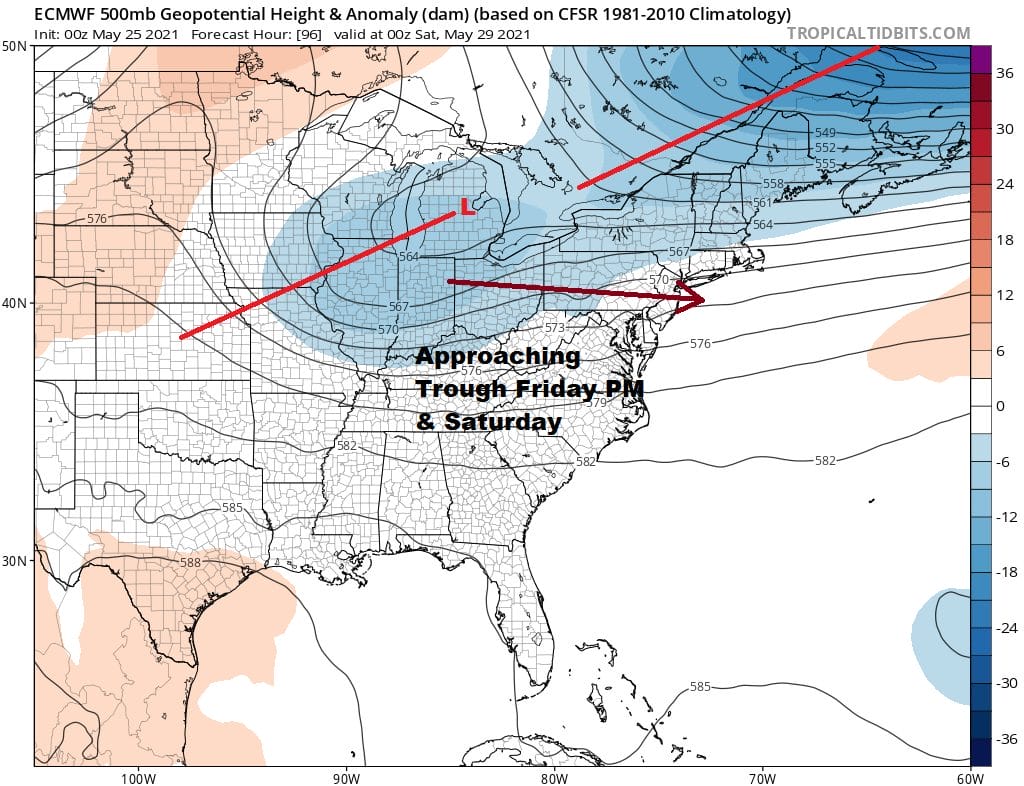
The issues is that not only do we have an upper trough heading our way but it comes from the northern jet stream. Normally this would be a good thing in that it would just move along and move through but the southern part of that trough is separating and that is going cause it to slow down. It is going to need a push to get it offshore and that probably doesn’t happen until Sunday.
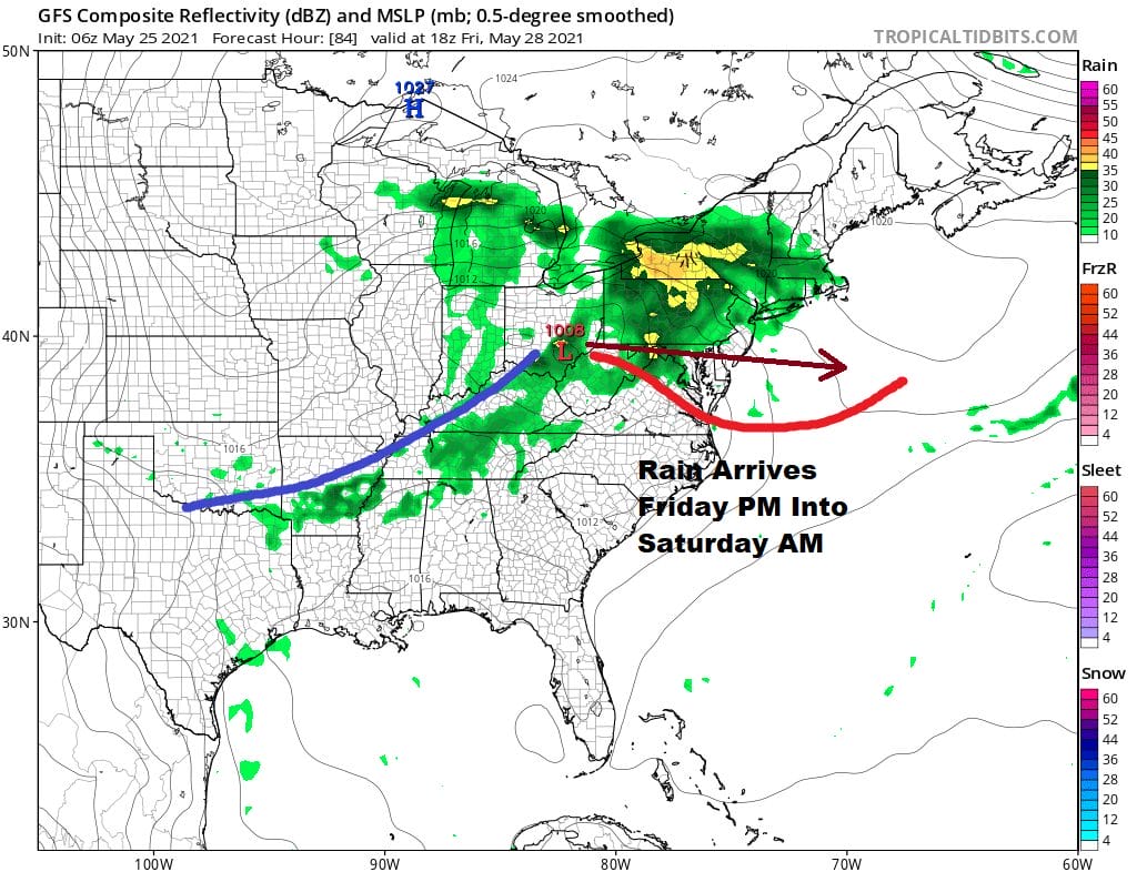
For Friday low pressure heads east southeast from the Upper Ohio Valley and eventually finds its way to off the New Jersey/Delaware coast Saturday morning. Rain comes in Friday afternoon and lasts into Friday night before pulling away Saturday morning probably around or before daybreak. Friday’s temperatures will be in the 60s.There will be lots of leftover clouds around on Saturday due to the wind being onshore northeast, the low to the east and the slow moving upper trough. The best way to describe Saturday is that it will be a gloom and doom type of day with lots of clouds all day long and the chance for some leftover scattered showers. Highs will be just into the lower 60s and it is quite possible that may see temperatures in the 50s all day if showers are more than just scattered around.
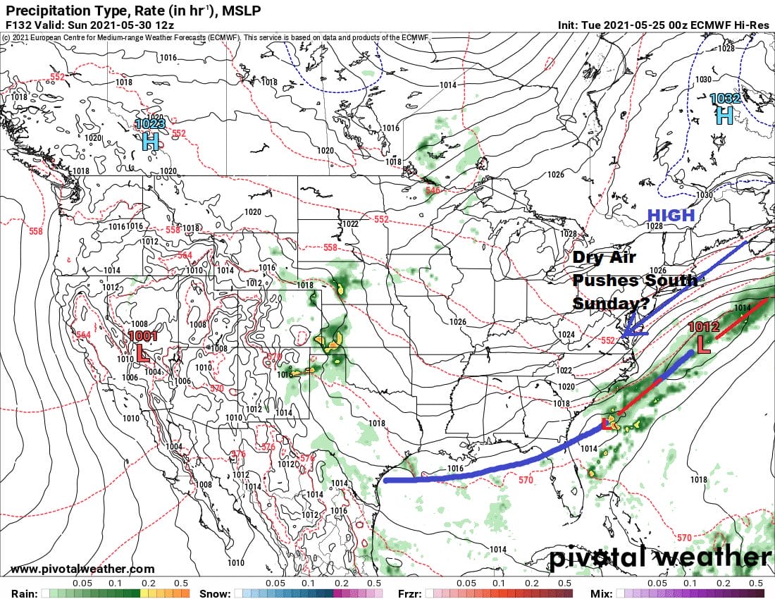
We are banking on the European model being correct and moving upper features along. This will allow a cool high in Northern New England to build southward on Sunday and the frontal boundary to the south of us sinks even further south. So we will call for decreasing clouds from north to south Sunday and increasing sun from north to south. Highs will be in the mid 60s to upper 60s so it will be on the cool side. Monday will see high pressure settle right over the Eastern US making it most likely the best day of the holiday weekend. We are looking at lots of sunshine. Temperatures will rise back to seasonal levels with most highs in the low 70s. All in all for this holiday weekend it is seems to be playing according to history. We lose 1 day (Saturday) and then we salvage Sunday followed by a good day from start to finish on Monday. This again assumes that the trough moves along according to the European model. If the slower GFS winds it could put Sunday at risk but even this model would argue for a better day Monday.
BE SURE TO DOWNLOAD THE FREE METEOROLOGIST JOE CIOFFI WEATHER APP &
ANGRY BEN’S FREE WEATHER APP “THE ANGRY WEATHERMAN!

MANY THANKS TO TROPICAL TIDBITS & F5 WEATHER FOR THE USE OF MAPS
Please note that with regards to any severe weather, tropical storms, or hurricanes, should a storm be threatening, please consult your local National Weather Service office or your local government officials about what action you should be taking to protect life and property.