Nam Model Offers Surprise Sunday Night

Every winter season offers a couple of surprises. Actually some areas have seen surprises and they have been mainly over Long Island and Southernmost New England over the last few weeks. We mentioned a few days ago that the European weather model was showing something like this over the last few days. Tuesday night we did put up a Cheap Thrill Alert with an early call snow map that went up this afternoon. Once I get a good look at the European I will adjust this on Friday.
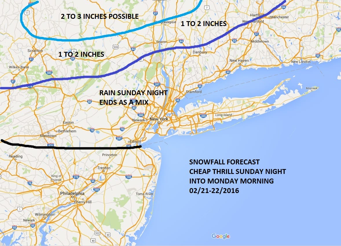
Tonight’s NAM model has locked into the European models idea that after a cold front moves through Sunday, a wave will develop on that front. The air aloft coming down on the NAM model is cold and this could be another top to bottom event; just like the one that hit Long Island with snow a few weeks ago.
Nam Model Offers Surprise Sunday Night NAM 850 MB Level Temperatures & Surface
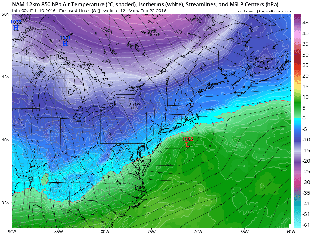
This is the profile of the surface with the temperatures at 5000 ft. This is level we often look at to see the magnitude of the cold air aloft. The NAM model is surprisingly cold aloft and even at the surface it brings temperatures close to 32. The area in blue shows temperatures aloft below freezing. I want to go back to the Long Island event a few weeks ago that produced 1 foot snows in some places. Now it is not the same thing and I’m not saying that the outcome is going to be the same. What I am saying is that in that event the air was not all that cold. In fact I posted the night before how the surface temperatures were so warm that you could not find a temperature below 32 anywhere withing 400 miles of the coast. It had been in the 50s during the day and the 60s the day before. However it all worked its way down aloft and even the coldest models weren’t cold enough in terms of the ground temperatures. They dropped to 30 and even the coldest models weren’t cold enough on the dynamic cooling that took place. My point is that under the right circumstances it can happen!
Nam Model Offers Surprise Sunday Night NAM SURFACE MAP MONDAY MORNING 7AM

Now here is the NAM surface map for Monday morning. What it bascially says is that you have a deepening little wave that does everything perfectly. You get a narrow band of intense precipitation that cools the atmosphere even further and the result is snow on the northern side. The European this afternoon is similar though a bit less cold than the NAM but not far away. The fact that the European has shown this idea for days and the NAM has latched on to lends support to the idea that something is going to happen Sunday night. Now we will have to reevaluate this in the morning once I get a good look at the European run.
With regards to the midweek storm the problems with multiple weather systems aloft running around remains an issue in the forecast. My latest video explains that.
Nam Model Offers Surprise Sunday Night Video Analysis
NATIONAL WEATHER SERVICE SNOW FORECASTS
LATEST JOESTRADAMUS ON THE LONG RANGE
Weather App

Winter is INSANE! With yet another threat for a coastal storm don’t be without Meteorologist Joe Cioffi’s weather app. It is really a meteorologist app because you get my forecasts and my analysis and not some automated computer generated forecast based on the GFS model. This is why your app forecast changes every 6 hours. It is model driven with no human input at all. It gives you an icon, a temperature and no insight whatsoever.
It is a complete weather app to suit your forecast needs. All the weather information you need is right on your phone. Android or I-phone, use it to keep track of all the latest weather information and forecasts. This weather app is also free of advertising so you don’t have to worry about security issues with your device. An accurate forecast and no worries that your device is being compromised.
Use it in conjunction with my website and my facebook and twitter and you have complete weather coverage of all the latest weather and the long range outlook. The website has been redone and upgraded. Its easy to use and everything is archived so you can see how well Joe does or doesn’t do when it comes to forecasts and outlooks.
Just click on the google play button or the apple store button on the sidebar for my app which is on My Weather Concierge. Download the app for free. Subscribe to my forecasts on an ad free environment for just 99 cents a month.
Get my forecasts in the palm of your hand for less than the cost of a cup of Joe!
![]()