Nam Model Moving West
LATEST WEATHER MODEL ANALYSIS ON
TROPICAL DEPRESSION 9, TROPICAL DEPRESSION 8 HURRICANE GASTON
JOESTRADAMUS
Nam Model Moving West
Tropical Depression 9 Stationary

First off with regards to Tropical Depression 9 it remains stationary in the Gulf of Mexico. Top winds are 35 mph. The National Hurricane Center says they will wait for a NOAA plane to get there and check things out before upgrading or not which makes sense since it isn’t moving.
...DEPRESSION NEARLY STATIONARY BUT SHOULD RESUME HEADING FOR THE
FLORIDA GULF COAST TODAY...
...EXPECTED TO STRENGTHEN...


SUMMARY OF 1000 AM CDT...1500 UTC...INFORMATION
-----------------------------------------------
LOCATION...24.6N 88.0W
ABOUT 395 MI...640 KM SSW OF APALACHICOLA FLORIDA
ABOUT 415 MI...665 KM WSW OF TAMPA FLORIDA
MAXIMUM SUSTAINED WINDS...35 MPH...55 KM/H
PRESENT MOVEMENT...STATIONARY
MINIMUM CENTRAL PRESSURE...1001 MB...29.56 INCHES


WATCHES AND WARNINGS
--------------------
CHANGES WITH THIS ADVISORY:

A Tropical Storm Watch has been issued for the United States
Atlantic coast from Marineland Florida to Altamaha Sound Georgia.

SUMMARY OF WATCHES AND WARNINGS IN EFFECT:

A Hurricane Watch is in effect for...
* Anclote River to Indian Pass

A Tropical Storm Warning is in effect for...
* Anclote River to the Walton/Bay County line

A Tropical Storm Watch is in effect for...
* Marineland Florida to Altamaha Sound Georgia

A Hurricane Watch means that hurricane conditions are possible
within the watch area.  A watch is typically issued 48 hours before
the anticipated first occurrence of tropical-storm-force winds,
conditions that make outside preparations difficult or dangerous.

A Tropical Storm Warning means that tropical storm conditions are
expected somewhere within the warning area within 36 hours.

A Tropical Storm Watch means that tropical storm conditions are
possible within the watch area, generally within 48 hours.

Interests along the United States east coast from Georgia through
the Carolinas should monitor the progress of this system.

For storm information specific to your area, including possible
inland watches and warnings, please monitor products issued by your
local National Weather Service forecast office.


DISCUSSION AND 48-HOUR OUTLOOK
------------------------------
At 1000 AM CDT (1500 UTC), the center of Tropical Depression Nine
was located near latitude 24.6 North, longitude 88.0 West.  The
depression is currently nearly stationary.  A north-northeastward
motion is expected to begin later today, and a turn toward the
northeast with increasing forward speed is expected on Thursday.  On
the forecast track, the center of the tropical cyclone will approach
the northwest Florida coast in the warning area on Thursday
afternoon.

Maximum sustained winds are near 35 mph (55 km/h) with higher gusts.
Strengthening is forecast during the next 48 hours, and the
depression is expected to become a tropical storm later today, and
it could be near hurricane strength by the time landfall occurs.

The estimated minimum central pressure is 1001 mb (29.56 inches).
NAM MODEL MOVING WEST
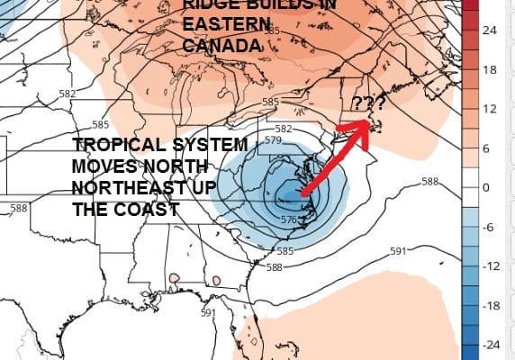
With the tropical depression remaining essentially stationary it has changed the profile of what is happening along the east coast. The longer it sits in the Gulf of Mexico, the greater change it has of missing the influence of the deep upper trough forecast to move through the east.
Nam Model Moving West
Upper Air Thursday Afternoon
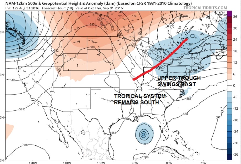
That trough would kick the tropical system out to sea. However if it misses it completely it will then basically act on its own. A piece of that trough gets left behind and then vigorously cuts off from the main jet stream. There would be nothing there to kick it out to the east.
Nam Model Moving West
Nam Model Upper Air Saturday Evening
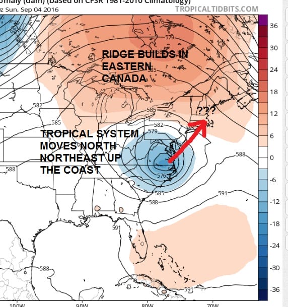
You can see it above on the NAM 84 upper air map. The system essentially is trapped underneath that big ridge and there appears to be nothing upstream or to the west to kick it out. The surface result on the nam is an inland low that moves up the through North Carolina by Saturday evening and has rain arriving here by that time frame.
Nam Model Moving West
Surface Map Saturday Evening
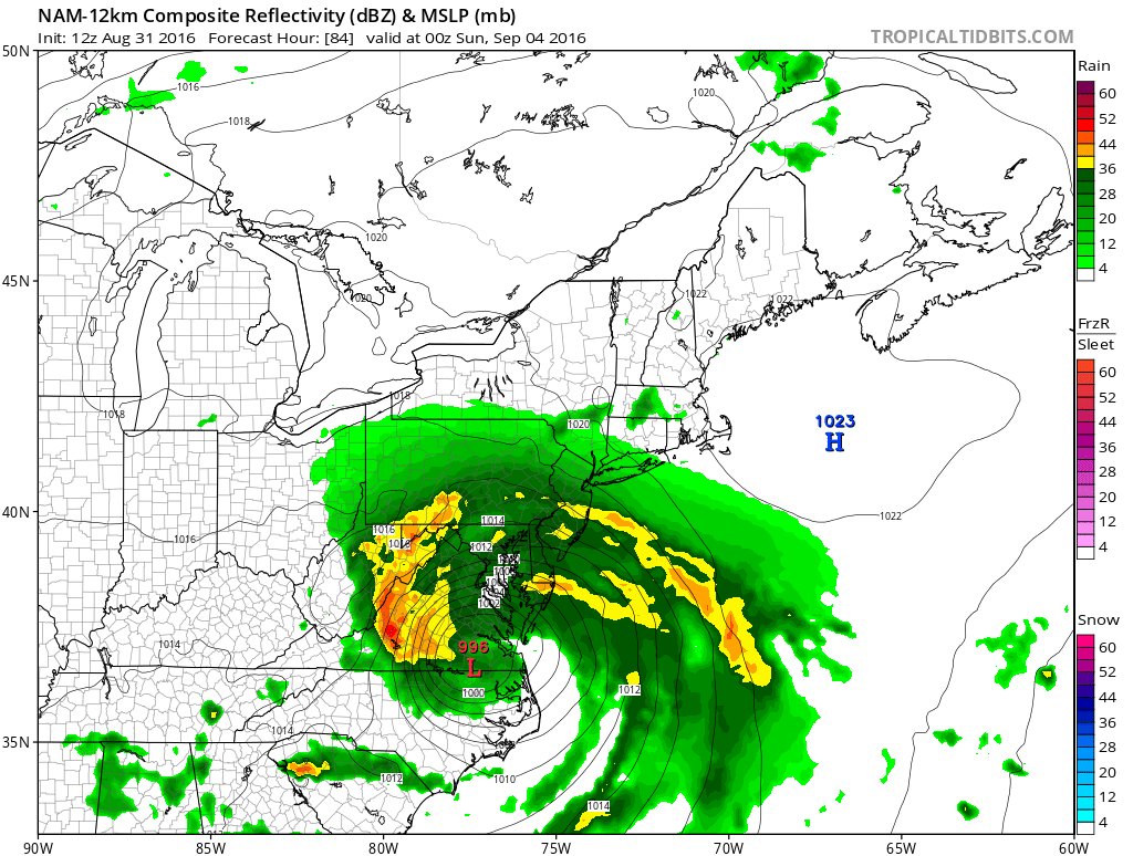
Now let me get a few things straight here. First off THIS IS NOT SANDY. Second..THIS IS NOT SANDY..and in case we forget to mention this..THIS IS NOT SANDY!!!
This is one model’s solution and given the constructs of what has been happening, it is not an impossible solution. The one good thing about this is that this could potentially be a serious drought reliever for dry areas of the northeast. Something like this would be much like a winter time nor’easter and there will be of course some tidal flooding concerns. But this is all purely speculative here. I want to see what the other models do as they begin their runs this afternoon. Still the NAM offers an interesting solution.
FiOS1 News Weather Forecast For Long Island
FiOS1 News Weather Forecast For New Jersey
FiOS1 News Weather Forecast For Hudson Valley
NATIONAL WEATHER SERVICE SNOW FORECASTS
LATEST JOESTRADAMUS ON THE LONG RANGE
Weather App

Don’t be without Meteorologist Joe Cioffi’s weather app. It is really a meteorologist app because you get my forecasts and my analysis and not some automated computer generated forecast based on the GFS model. This is why your app forecast changes every 6 hours. It is model driven with no human input at all. It gives you an icon, a temperature and no insight whatsoever.
It is a complete weather app to suit your forecast needs. All the weather information you need is right on your phone. Android or I-phone, use it to keep track of all the latest weather information and forecasts. This weather app is also free of advertising so you don’t have to worry about security issues with your device. An accurate forecast and no worries that your device is being compromised.
Use it in conjunction with my website and my facebook and twitter and you have complete weather coverage of all the latest weather and the long range outlook. The website has been redone and upgraded. Its easy to use and everything is archived so you can see how well Joe does or doesn’t do when it comes to forecasts and outlooks.
Just click on the google play button or the apple store button on the sidebar for my app which is on My Weather Concierge. Download the app for free. Subscribe to my forecasts on an ad free environment for just 99 cents a month.
Get my forecasts in the palm of your hand for less than the cost of a cup of Joe!
![]()
![]()