Nam Model Brings Julia Remnants Northward
JOESTRADAMUS AT THE HICKSVILLE LIBRARY ON WEDNESDAY OCTOBER 5TH 7:15PM
Nam Model Brings Julia Remnants Northward
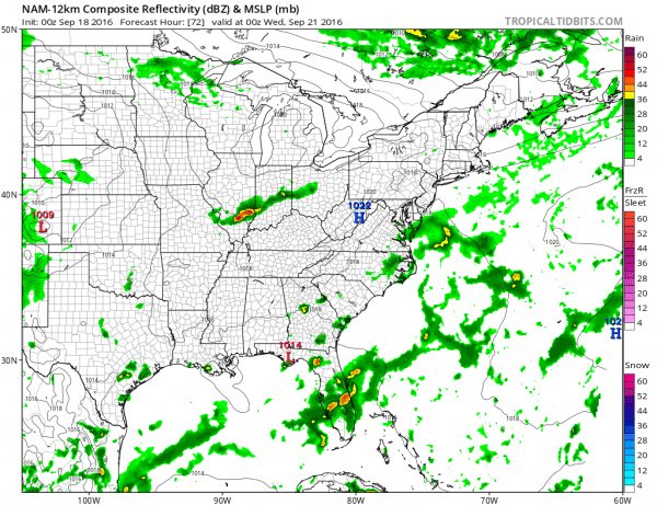
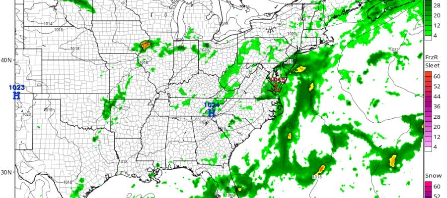
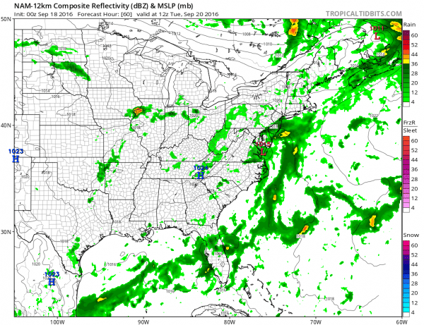
We can only hope that this is true! The new NAM model tonight wants to bring the remnant circulation of Tropical Storm Julia northwestward into the Carolinas and then northward up the coast. Unfortunately after Tuesday morning the remnant low and the rain pretty much disappear before moving far enough north into drought stricken areas.
NAM MODEL TUESDAY MORNING
NAM MODEL TUESDAY EVENING

It is sad because an intact remnant circulation could at least extend a good soaking rain here into Tuesday in areas that need it badly. But after Tuesday morning everything just falls apart which makes sense as a ridge builds aloft. But sometimes these things hang on longer than advertised so we will watch what other models do with this.
..JULIA'S DEMISE IS DIFFICULT TO FORECAST...


SUMMARY OF 1100 PM EDT...0300 UTC...INFORMATION
-----------------------------------------------
LOCATION...30.6N 76.5W
ABOUT 255 MI...410 KM SE OF CHARLESTON SOUTH CAROLINA
MAXIMUM SUSTAINED WINDS...30 MPH...45 KM/H
PRESENT MOVEMENT...NW OR 320 DEGREES AT 3 MPH...6 KM/H
MINIMUM CENTRAL PRESSURE...1010 MB...29.83 INCHES


WATCHES AND WARNINGS
--------------------
There are no coastal watches or warnings in effect.


DISCUSSION AND 48-HOUR OUTLOOK
------------------------------
At 1100 PM EDT (0300 UTC), the center of Tropical Depression Julia
was located near latitude 30.6 North, longitude 76.5 West. The
depression is moving toward the northwest near 3 mph (6 km/h), and
only a small northward drift is expected during the next day or
so.

Maximum sustained winds remain near 30 mph (45 km/h) with higher
gusts. Julia is expected to become a remnant low on Sunday.

The estimated minimum central pressure is 1010 mb (29.83 inches).


HAZARDS AFFECTING LAND
----------------------
None.
Strong northerly shear continues unabated and shows no signs of relaxing. Thunderstorms flare up near the center only to see them blown apart by the shear.

More than likely this will be a remnant low before too long and sadly won’t bring more rain to our area.

Meanwhile Tropical Storm Karl is fighting its own issues with shear tonight. The new advisory lowers top winds to 40 mph. Tropical Storm Karl will move into an area more favorable for development by Monday but if the strong wind shear continues, what exactly will there be left?
...KARL STRUGGLING OVER THE CENTRAL ATLANTIC...


SUMMARY OF 1100 PM AST...0300 UTC...INFORMATION
-----------------------------------------------
LOCATION...17.8N 41.3W
ABOUT 1350 MI...2175 KM E OF THE LEEWARD ISLANDS
MAXIMUM SUSTAINED WINDS...40 MPH...65 KM/H
PRESENT MOVEMENT...W OR 265 DEGREES AT 12 MPH...19 KM/H
MINIMUM CENTRAL PRESSURE...1006 MB...29.71 INCHES


WATCHES AND WARNINGS
--------------------
There are no coastal watches or warnings in effect.


DISCUSSION AND 48-HOUR OUTLOOK
------------------------------
At 1100 PM AST (0300 UTC), the center of Tropical Storm Karl was
located near latitude 17.8 North, longitude 41.3 West. Karl is
moving toward the west near 12 mph (19 km/h).  A westward to
west-northwestward motion with some increase in forward speed is
expected during the next couple of days.

Maximum sustained winds have decreased to near 40 mph (65 km/h) with
higher gusts. Karl is forecast to begin to strengthen on Monday.

Tropical-storm-force winds extend outward up to 230 miles (370 km)
northeast of the center.

The estimated minimum central pressure is 1006 mb (29.71 inches).


HAZARDS AFFECTING LAND
----------------------
None.
We will of course take a look at this again in the morning along with all the overnight models. At least the NAM model shows more rainfall on this run then in its prior 2 runs thpugh the heaviest rain is to our south.
MENTION JOE CIOFFI AND GET A 5% DISCOUNT
WINTER 2016-2017 PART 1 OCEAN WATER TEMPERATURES
WINTER 2016-2017 PART 2 ARCTIC SEA ICE AND SIBERIAN SNOW COVER
FiOS1 News Weather Forecast For Long Island
FiOS1 News Weather Forecast For New Jersey
FiOS1 News Weather Forecast For Hudson Valley
NATIONAL WEATHER SERVICE SNOW FORECASTS
LATEST JOESTRADAMUS ON THE LONG RANGE
Weather App
Don’t be without Meteorologist Joe Cioffi’s weather app. It is really a meteorologist app because you get my forecasts and my analysis and not some automated computer generated forecast based on the GFS model. This is why your app forecast changes every 6 hours. It is model driven with no human input at all. It gives you an icon, a temperature and no insight whatsoever.
It is a complete weather app to suit your forecast needs. All the weather information you need is right on your phone. Android or I-phone, use it to keep track of all the latest weather information and forecasts. This weather app is also free of advertising so you don’t have to worry about security issues with your device. An accurate forecast and no worries that your device is being compromised.
Use it in conjunction with my website and my facebook and twitter and you have complete weather coverage of all the latest weather and the long range outlook. The website has been redone and upgraded. Its easy to use and everything is archived so you can see how well Joe does or doesn’t do when it comes to forecasts and outlooks.
Just click on the google play button or the apple store button on the sidebar for my app which is on My Weather Concierge. Download the app for free. Subscribe to my forecasts on an ad free environment for just 99 cents a month.
Get my forecasts in the palm of your hand for less than the cost of a cup of Joe!


