Much Cooler Days & Chilly Nights Into Friday
Another Warm Up Over The Weekend
ll
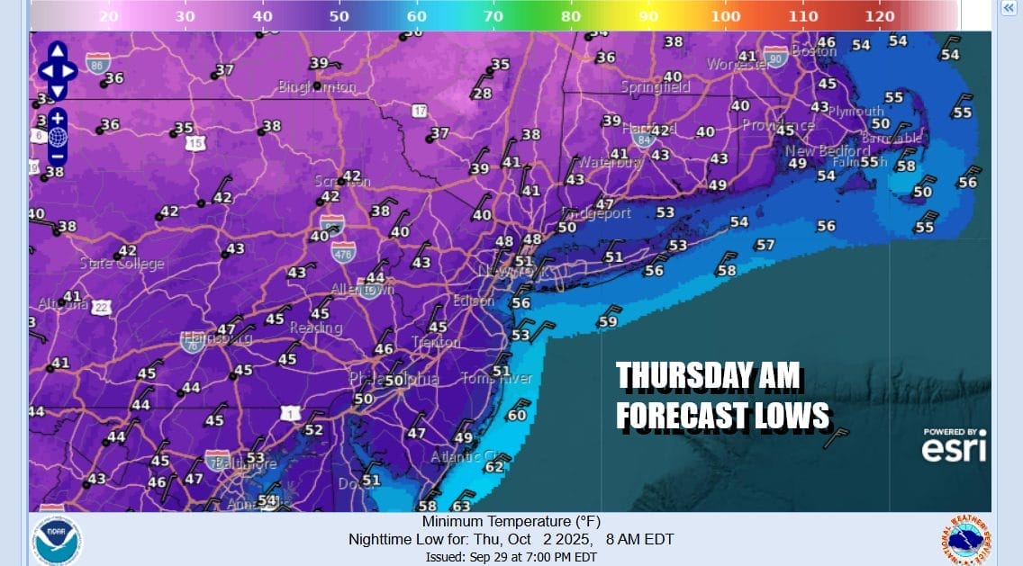
Cool days are going to be followed by chilly nights and this is going to be the coldest stretch of weather we have seen so far this early Autumn. Skies tonight will be mostly clear. There will be that north to northeast breeze that will continue. Morning lows along the coast and warmer urban areas will be in the lower 50s but just away from the coast it will be in the 40s. Go north of Interstate 84 in New York State and Connecticut and you will see low temperatures Thursday morning in the upper 30s. No frosts are forecast however.
SATELLITE WITH LIGHTNING STRIKES
WEATHER RADAR
Chilly conditions will continue Thursday as well the northeast breeze. We will have lots of sunshine but daytime temperatures will be topping out in the low to middle 60s. That will be followed by another chilly night of mainly clear skies with lows again in the lower 50s coast, 40s inland and 30s well inland north and northeast of the coastal areas.
The high pressure cell from New England will reform to the south in Virginia. Winds will go from northeast to west. This will allow temperatures to rise some. Friday will be another day with lots of sunshine. Afternoon highs will begin to move up and they should reach the upper 60s with some warmer spots touching 70.
The high pressure area will be sitting in the Middle Atlantic states over the weekend and into early next week so no rain is in the forecast through at least Tuesday of next week. Saturday we should see plenty of sunshine with highs in the low to mid 70s. Sunday will be warmer with sunshine taking highs to the upper 70s and lower 80s. As far as rain goes the next cold front and with it, the next chance for rain probably comes late next Wednesday into Thursday. No tropical storms or hurricanes are in the cards ov
BE SURE TO DOWNLOAD THE FREE METEOROLOGIST JOE CIOFFI WEATHER APP &
ANGRY BEN’S FREE WEATHER APP “THE ANGRY WEATHERMAN!
MANY THANKS TO TROPICAL TIDBITS FOR THE USE OF MAPS
Please note that with regards to any severe weather, tropical storms, or hurricanes, should a storm be threatening, please consult your local National Weather Service office or your local government officials about what action you should be taking to protect life and property.