
Mothers Day & Weekend Looking Like A Washout

Mothers Day & Weekend Looking Like A Washout
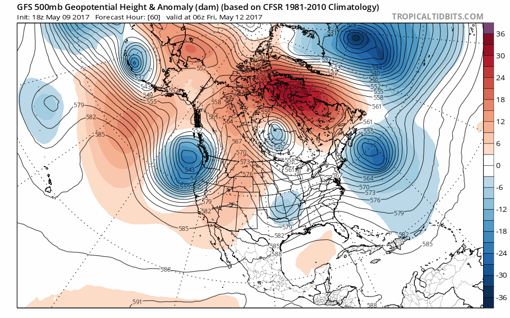
There has been this sort of unwritten rule the the weather on Mothers Day must be beautiful. I don’t quite know where it comes from but we can say based on what we are seeing that this definitely WILL NOT be the case this Mothers Day. The blocking pattern that has been impacting the weather across the Eastern United States is about to break down as the pattern shifts. It is usually at these moments that the atmosphere gets a bit of a headache that it has to relieve. It seems to want to do it in the form of a coastal low and a mid May noreaster to come right over the weekend.
MOTHERS DAY & WEEKEND RAINFALL FORECAST
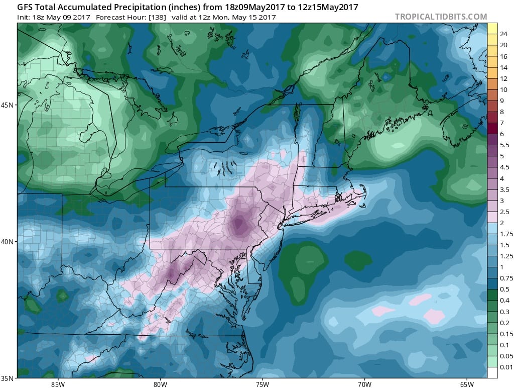
All the major weather models would point to a 2 to 4 inch rainfall across much of the interior Middle Atlantic states up to Southern New England. The late afternoon model run has shifted slightly northwestward but the general idea is that we are in the bowling alley here for a heavy rain. It is often that when blocks break down it creates tension in the atmosphere which needs to be relieved somehow. The disappearing block opens the door for low pressure in the Southwest US to come eastward. The upper trough from the north swings down and phases with the southern system. The result is a coastal low off the Mid Atlantic Coast and tracking northward.
MOTHERS DAY & WEEKEND GFS MODEL FRIDAY INTO SUNDAY
Track and strength will be the next question. The low tracking further east than the one last week would shift the axis of heavy rain to the coast but this looks like a widespread rain event with a gusty northeast wind for Saturday into Sunday.
MOTHERS DAY & WEEKEND GFS MODEL CLICK TO ANIMATE
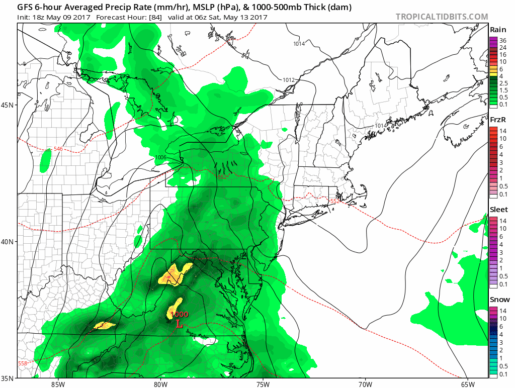
It would seem rain would develop early Saturday morning and it will continue into Sunday afternoon in some areas. That and the ocean wind will mean temperatures struggling in the 50s again. All the weather models today have the general idea and we see no reason to disagree with this. Unless the block holds on longer than forecast and suppresses all this to the south, it seems the entire weekend coming up will be a washout.
MANY THANKS TO TROPICAL TIDBITS FOR THE WONDERFUL USE OF THE MAPS

GET JOE A CIGAR IF YOU LIKE!
LANDSCAPE COMPANIES FOR YOUR SPRING SUMMER FALL NEEDS
LONG ISLAND ROCKLAND COUNTY Connecticut

![]()

ROCKLAND COUNTY TRI STATE SNOW REMOVAL JOHNSTOWN PA


FiOS1 News Weather Forecast For Long Island
FiOS1 News Weather Forecast For New Jersey
FiOS1 News Weather Forecast For Hudson Valley
NATIONAL WEATHER SERVICE SNOW FORECASTS
LATEST JOESTRADAMUS ON THE LONG RANGE
Weather App

Don’t be without Meteorologist Joe Cioffi’s weather app. It is really a meteorologist app because you get my forecasts and my analysis and not some automated computer generated forecast based on the GFS model. This is why your app forecast changes every 6 hours. It is model driven with no human input at all. It gives you an icon, a temperature and no insight whatsoever.
It is a complete weather app to suit your forecast needs. All the weather information you need is right on your phone. Android or I-phone, use it to keep track of all the latest weather information and forecasts. This weather app is also free of advertising so you don’t have to worry about security issues with your device. An accurate forecast and no worries that your device is being compromised.
Use it in conjunction with my website and my facebook and twitter and you have complete weather coverage of all the latest weather and the long range outlook. The website has been redone and upgraded. Its easy to use and everything is archived so you can see how well Joe does or doesn’t do when it comes to forecasts and outlooks.
Just click on the google play button or the apple store button on the sidebar for my app which is on My Weather Concierge. Download the app for free. Subscribe to my forecasts on an ad free environment for just 99 cents a month.
Get my forecasts in the palm of your hand for less than the cost of a cup of Joe!
![]()
