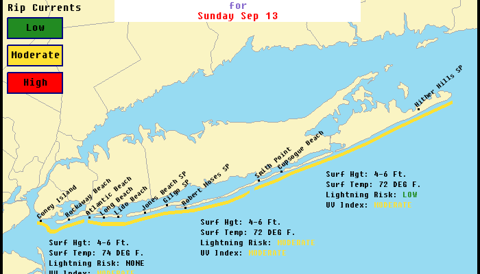
The beaches today will see a moderate risk of rip currents on Long Island but a low risk in New Jersey. Small Craft Advisories are posted for all of the coastal waters for today and likely to be up through Monday night for gusty winds and rough ocean seas.
FOR COASTAL NEW JERSEY
…SMALL CRAFT ADVISORY IN EFFECT FROM THIS EVENING THROUGH MONDAY AFTERNOON…
Synopsis: LOW PRESSURE OVER NEW YORK STATE MOVES NORTHEASTWARD TO NEW ENGLAND LATER TODAY. HIGH PRESSURE WILL THEN BUILD IN FROM THE SOUTHWEST AND WILL BE THE DOMINANT WEATHER FEATURE FOR MOST OF THE UPCOMING WEEK. A COLD FRONT WILL PROBABLY CROSS OUR REGION NEXT WEEKEND.
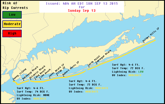
CONDITIONS SUPPORT THE DEVELOPMENT OF STRONGER
AND/OR MORE FREQUENT RIP CURRENTS. PLEASE SWIM
ONLY IN LIFE GUARDED AREAS.
LIGHTNING RISK……MODERATE. IMPLIES THAT THUNDERSTORMS ARE
POSSIBLE.
SURF HEIGHT………4 TO 6 FEET.
ULTRAVIOLET INDEX…MODERATE.
WATER TEMPERATURE…72 DEGREES.
WEATHER………….MOSTLY CLOUDY. A CHANCE OF SHOWERS. A CHANCE OF
THUNDERSTORMS AFTER 10 AM.
MAX TEMPERATURE…..AROUND 77.
WINDS……………WEST WINDS 5 TO 10 MPH.HERE IS THE TIDE INFORMATION…AT JONES INLET…HIGH TIDE IS AT 8:16 AM SUNDAY AND AT 8:26 PM SUNDAY.
LOW TIDE IS AT 2:21 PM SUNDAY.
AT FIRE ISLAND INLET…
HIGH TIDE IS AT 7:57 AM SUNDAY AND AT 8:07 PM SUNDAY.
LOW TIDE IS AT 2:19 PM SUNDAY.
HIGH TEMPERATURE…. IN THE UPPER 70S.
BEACH WINDS……… WEST WINDS 10 TO 15 MPH.
SURF……………. AROUND 3 FEET.
SWELL…………… SOUTH SWELL AROUND 3 FEET.
DOMINANT PERIOD….. 7 SECONDS.
SURF TEMPERATURE…. AROUND 75 DEGREES.
UVI INDEX……….. 4 – MODERATE.
RIP CURRENT RISK…. LOW. HOWEVER…STRONG CURRENTS CAN OCCUR NEAR
PIERS AND JETTIES. RIP CURRENTS ARE POSSIBLE
ELSEWHERE…ESPECIALLY DURING THE LOWER
PORTION OF THE TIDE CYCLE. SWIM IN AREAS WHERE
LIFE GUARDS ARE PRESENT AND TALK WITH THEM
ABOUT ANY HAZARDS IN THE SURF ZONE.
LIGHTNING THREAT…. NONE.TIDE INFORMATION…AT BARNEGAT INLET…LOW TIDE AT 2:32 AM…
HIGH TIDE AT 8:27 AM…
LOW TIDE AT 2:41 PM…
HIGH TIDE AT 8:39 PM…
Be sure to download my weather app and subscribe to my forecasts for just 99 cents a month. No ads and no security issues.