
Models forecasting late week snow threat with the European, Canadian, GFS and others all showing the same idea. It is seldom that models do this and they all seem to be in some sort of agreement though of course the devil is always in the details. When you see models forecasting late week snow threat and they are all on the same page it is a good idea to pay some attention.
Models Forecasting Late Week Snow Threat European Model
When it comes to major events and even moderate events it seems the European usually (but not always) has the upper hand in this. When all three point to the same idea usually the reliability factor is high.

This map is the European map for Day 5 which is Friday morning 1/22/2016. What we have is a split flow with a very strong southern stream disturbance that should be loaded with moisture. To the north is the northern jet which is very important. That jet feeds and keeps cold air in the northeast. It also prevents the system from lifting up to our west. Notice that the tilt of that southern system on the models is northeast southwest or what is known as a positive tilt. Being that the system is tilted this way east of the Mississippi river will prevent it from taking a track to the left. In the west we have a strong ridge building in response the the lead system and a deep system off the west coast of the United States. Notice by the way there is no blocking to speak of. This is an example of how you don’t necessarily need blocking for it to snow. We just came through a period of strong blocking which did not work well because everything in the atmosphere lined up all wrong for snow in the east.

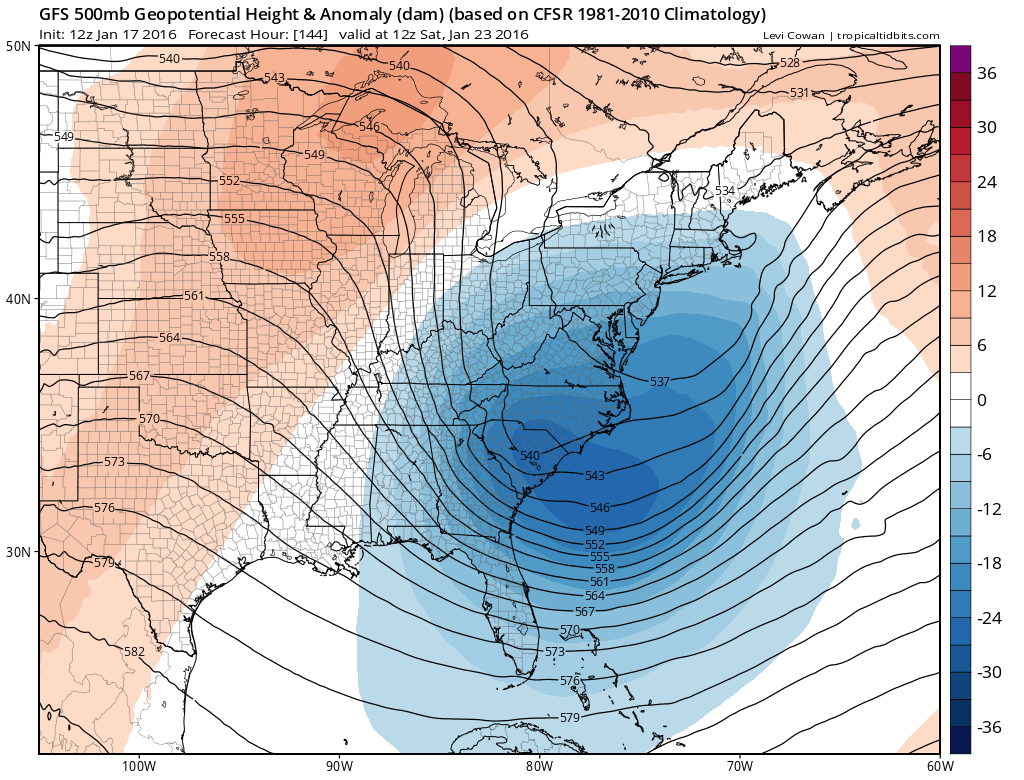
Now we move out to day 6 which is Saturday 1/23/2016. The strong upper air disturbance in the south moves to the coast. The jet to the north is still there keeping it from lifting up to the left. Cold air remains in place in the northeast. Everything seems to be lining up on the European model for a major east coast storm. Now remember that there are still things that could go differently and this is by no means gospel at this point. If the northern jet is too strong it could suppress everything south. If it is too weak it would a low a deeper low to possibly go left. These are the usual caveats. The European at this point is lined up about as perfectly for as winter storm as you might like. That has me concerned some this early in the game so we need to see model consistency over the next several days.
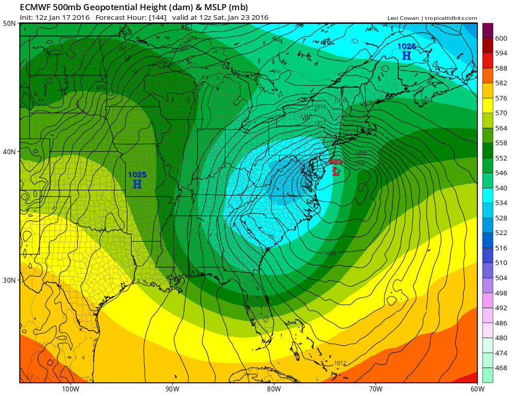
This is the surface map for Saturday morning overlaying the upper air flow so you can see clearly how it lines up. The model has an intense storm just offshore. Noreaster conditions with gales and coastal flooding plus a full moon all coming together here on this run of guidance. In terms of snow this is the European snow map forecast.
Models Forecasting Late Week Snow Threat European Snowfall Forecast
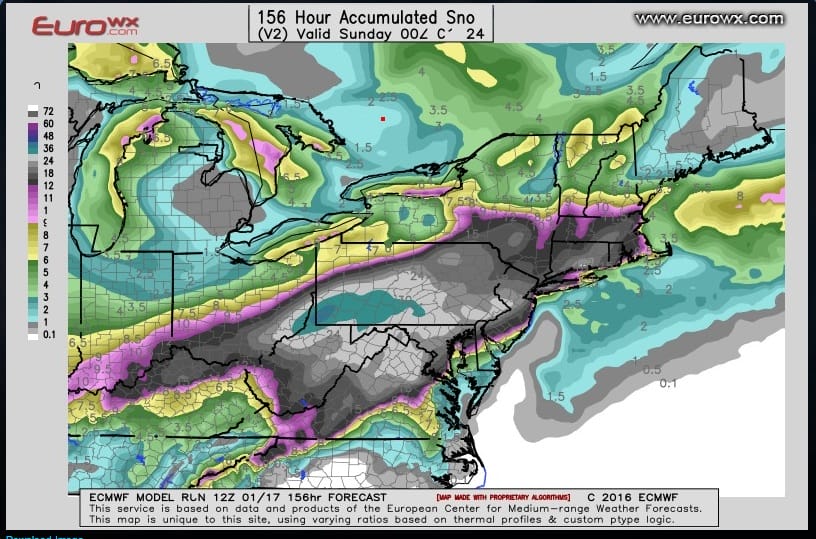
This map is courtesy of Eurowx.com and we thank them for that. The snowfall forecast here makes complete sense with what the model is predicting at least at the moment. I would view this map cautiously because remember we are 5 days out.
Models Forecasting Late Week Snow Threat Canadian Model
The Canadian model has the same idea except that the upper low is further north so this brings rain issues into the equation for some coastal areas. That observation is obvious given the further north position but it still means a similar outcome but just shift the heavy snow area further north. This could be a Canadian model bias since it likes to do this.
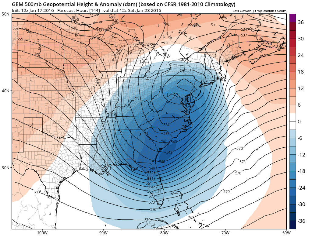

The low on the Canadian is a little more tucked in to the coast which makes sense given its upper low position. It doesn’t mean its right but it is an option to consider and again this is going to be something that can’t be worked out until we are inside 72 hours at least.
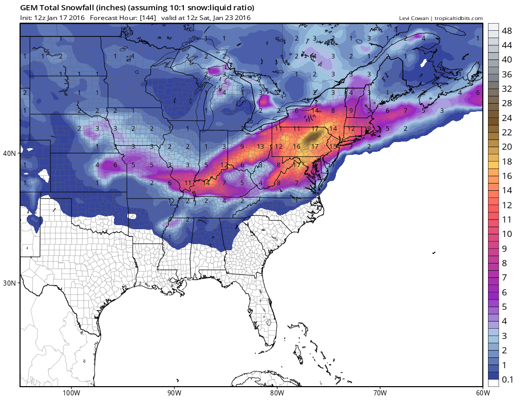
The Canadian snowfall map forecast is still very bullish for snow for much of the Middle Atlantic and the northeast though it brings the heavy snow axis a little further north.
PLEASE VIEW THESE SNOWFALL MAPS WITH A HUGE GRAIN OF SALT. THEY ARE FORECASTS AND NOT REALITY.
Models Forecasting Late Week Snow Threat GFS Model

The GFS model today is the weakest of the three as it has a weaker upper air system that moves along faster and therefore it has literally half the snow amounts of the other two. The model has shown a stronger low prior to this run so we will see on the mid afternoon run whether it goes back to a stronger solution or whether it is on to something. But the idea of how all this evolves is the same as the other two.
So there you have it. 3 models all sort of on the same page in the broad sense but differing on the details. We have 5 days to watch this evolve. If this were a different kind of winter I would show some confidence at this point but given every snowflake so far has been a battle waging on world war, I would view all this cautiously. Is the risk for a major storm there? Yes absolutely? Will it happened. We will find out soon enough, as the stomach turns.
Afternoon video analysis of all 3 major models.
NATIONAL WEATHER SERVICE SNOW FORECASTS
LATEST JOESTRADAMUS ON THE LONG RANGE
Weather App

Winter is here! Don’t be without Meteorologist Joe Cioffi’s weather app. It is a complete weather app to suit your forecast needs. All the weather information you need is right on your phone. Android or I-phone, use it to keep track of all the latest weather information and forecasts. This weather app is also free of advertising so you don’t have to worry about security issues with your device. An accurate forecast and no worries that your device is being compromised.
Use it in conjunction with my website and my facebook and twitterand you have complete weather coverage of all the latest weather and the long range outlook. The website has been redone and upgraded. Its easy to use and everything is archived so you can see how well Joe does or doesn’t do when it comes to forecasts and outlooks.
Just click on the google play button or the apple store button on the sidebar for my app which is onMy Weather Concierge. Download the app for free. Subscribe to my forecasts on an ad free environment for just 99 cents a month.
Get my forecasts in the palm of your hand for less than the cost of a cup of Joe!
![]()
![]()