Mid Spring May Snow Possible Well Inland Friday Night Into Saturday Morning

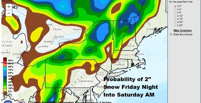
43 years ago on May 9th 1977 i remember being in my political science class senior year high of senior year of high school when snow began to fall. This stopped the history class in its tracks and Mr Maika asked me to explain what was happening! It is one of those memories everyone has that sticks in one’s mind forever. Here we are 43 years later and we may see some wet snow flakes mixing in with rain that is forecast to fall late Friday into Saturday morning. It is a pattern that we didn’t see at all during the winter. With all the strange things going on in the last 2 months with everything from a pandemic to murder hornets..why not snow in mid spring! This is a set up that might bring accumulating snows to elevated areas above say 1500 feet north and west of the coast. The Weather Prediction Center has everything well north and west for the best chances for 2 inches or more. They actually have chances od an inch closer to the coast but again it would be in elevated areas.
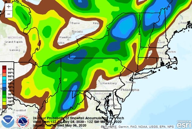
Between the low that develops along the coast and races into Northern New England Saturday and the upper trough that will be moving overhead, either see some wet snow flakes mixing in with the rain during the early morning hours Saturday as the low goes by or we see some snow showers and perhaps some graupel ( an uncrystalized snowflake) during the day Saturday. Combine that with gusty winds of 30 to 40 mph from the northwest and temperatures holding in the 40s and you have the recipe for a very cold day feeling more like mid March than early May.

Two troughs are involved here. One is in the Northern Plains, the other drops from Canada to the northern Great Lakes and phases with the short wave coming out from the Plains. We are showing you the NAM model which is the most aggressive of the model series today. it seems overdone in my view regarding the amount of snow it produces. The strong upper low to the north will create a very cold environment aloft allowing rain to change to wet snow. Since most of this falls Friday night into Saturday morning, we should consider the possibility of accumulating snow in places like the Catskills, Poconos, and the Berkshires as well as of course elevated areas of Upstate NY and Norther New England.

During Saturday with the low in the Gulf of Maine we will have a very tight pressure gradient overhead which means strong winds gusting to 40 mph at times. There will also be instability rain and snow showers around even down to the coast thanks to the very cold unstable air aloft. Temperatures will likely drop into the 30s Friday night and not get much out of the 40s on Saturday in most places.
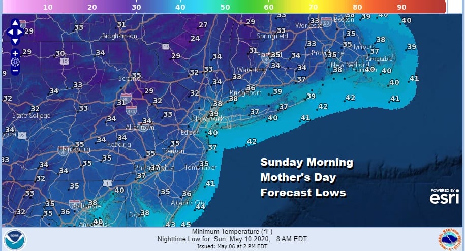
The next issue will be Sunday morning which is Mother’s Day. We will be waking up to temperatures in the 30s and some places will be near or below freezing which sets us up for a late season freeze here. I had advised days ago to hold off planting temperature sensitive vegetables and annuals until after this weekend and i stand by that recommendation.
SATELLITE

REGIONAL RADAR

Meanwhile tonight we have some showers around thanks to low pressure developing off the New Jersey coast that will be headed out to the northeast overnight. The rain isn’t especially impressive and most rainfall amounts will be under a tenth of an inch. This all pulls out to the northeast overnight and weather conditions improve by morning.
LOCAL RADAR NEW YORK CITY

LOCAL RADAR PHILADELPHIA


Thursday looks good with some sunshine and that means temperatures should rebound back into the 60s for highs. Friday look for increasing clouds as the rain and wet snow (depending on your location) gets underway in the late afternoon and evening.
BE SURE TO DOWNLOAD THE FREE METEOROLOGIST JOE CIOFFI WEATHER APP &
ANGRY BEN’S FREE WEATHER APP “THE ANGRY WEATHERMAN!
MANY THANKS TO TROPICAL TIDBITS FOR THE USE OF MAPS
Please note that with regards to any severe weather, tropical storms, or hurricanes, should a storm be threatening, please consult your local National Weather Service office or your local government officials about what action you should be taking to protect life and property.


