Memorial Day Weekend Outlook More Dry Than Wet, Severe Weather Risk Monday

Memorial Day Weekend Outlook More Dry Than Wet, Severe Weather Risk Monday

We have arrived at the doorstep of the holiday weekend and it starts of with today being “getaway day”. The overall outlook for the next 4 days is that it will be dry much of the time with two periods of time where we may have issues. The simulated satellite loop above shows that we have two weather systems to deal with. The first will come late Saturday into Saturday night. The second one and the more important one is Monday when a strong cold front approaches and we have to deal with some showers and thunderstorms at some point; probably later in the day Monday and Monday night.
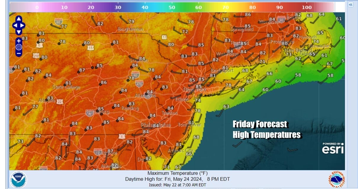
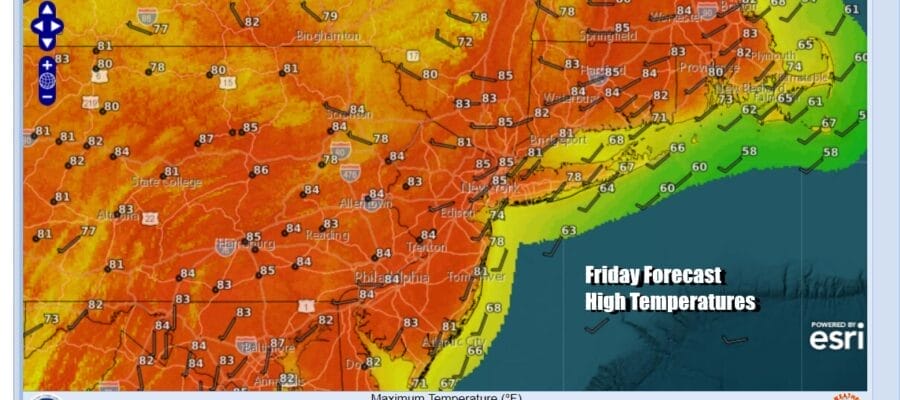
Today offers few weather issues. There is a disturbance that is moving along across the Mid Atlantic states and it is producing some scattered showers and thunderstorms. This will slide out to the southeast and other than some blow off high clouds, we should be in good shape today. We will be no worse than partly sunny and temperatures will be on the warm side as highs reach into the 80s inland. South winds along the immedate coast will keep south and east facing shorelines cooler as is often the case this time of year. Highs will be about 10 degrees or so lower along the Jersey shore as well as the coasts of Long Island, Southern & Southeastern New England.
SATELLITE WITH LIGHTNING STRIKES

WEATHER RADAR

Most lows tonight will be in the mid 50s to lower 60s under a mix of clear skies and some clouds. Saturday should be dry during the dayside at least with sunshine giving way to arriving clouds especially in the afternoon. High temperatures Saturday will be in the 80s inland and cooler 70s along the coast as again we deal with winds going to the south along the immediate coast.

There will be some scattered showers and thunderstorms that develop inland Saturday in Pennsylvania and they will likely weaken somewhat as the move eastward Saturday night. We will will still include the chance there could be some scattered showers or even the odd thunderstorm during the overnight period but it is conceivable that some areas see little in the way of rain. This then leaves us with Sunday as the best weather day of the holiday weekend with sunshine (after some morning leftover clouds) and highs again will reach into the 80s inland and cooler temperatures along the immediate coast.

A developing low in the Southern Plains over the weekend will take a track to the Great Lakes Sunday night and Monday. Coupled with a strong upper trough and a strengthening surface low, a cold front will set up to the west Sunday night and then move eastward for Monday. The dynamics are in place for showers and thunderstorms and there is the likelihood for severe weather risk over parts of the Northeast & Middle Atlantic states later Monday into Monday night.

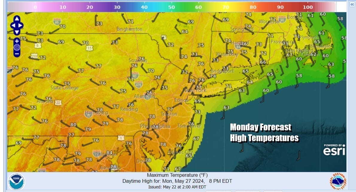
It is possible that we will be dry Memorial Day into the early afternoon and then we deal with an increasing risk for showers and thunderstorms and the chance for severe weather in the late afternoon and Monday night. Temperatures Monday will be lower and humidity levels will be higher thanks to more cloud cover. Highs will be mostly in the 70s with 60s along the immediate coast.
The Storm Prediction Center does mention the potential for severe weather in the Northeast and Mid Atlantic for Monday but given the uncertainty in some of the longer range models, they are say predictability is too low at this time. Over the weekend I expect them to show some risk for Eastern Pennsylvania to Southern New England. Weather conditions should improve early next week. We will keep you updated on weather developments throughout the weekend.
BE SURE TO DOWNLOAD THE FREE METEOROLOGIST JOE CIOFFI WEATHER APP &
ANGRY BEN’S FREE WEATHER APP “THE ANGRY WEATHERMAN!
MANY THANKS TO TROPICAL TIDBITS FOR THE USE OF MAPS
Please note that with regards to any severe weather, tropical storms, or hurricanes, should a storm be threatening, please consult your local National Weather Service office or your local government officials about what action you should be taking to protect life and property.


