Memorial Day Weekend Gearing Up Clouds Rain Later Friday Into Saturday
Better Weather Sunday Monday
It was an absolutely beautiful day for most folks from the Northern Mid Atlantic. At worst it was partly sunny and from Northeastern New Jersey through Southern New England it was just about cloud free from start to finish. Inland temperatures made it into the low 70s. Coastal temperatures topped in the mid 50s to low 60s. The wind was not a major issue. Clouds and rain continue to lie to our south across the Carolinas into Western Virginia. They have not made their move to the northeast yet but they will in short order. Clear skies tonight might give way to some clouds south of NYC. No radiational cooling tonight with most lows forecast to be in the upper 40s and lower 50s.
SATELLITE

REGIONAL RADAR

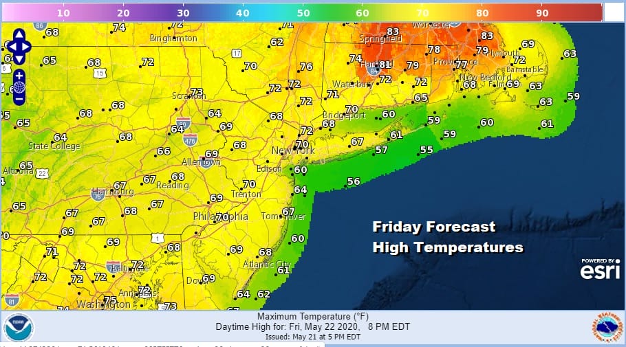
Radar is still showing rain moving northwestward in Virginia but as we stated earlier this area will start to move more north and northeast overnight and on Friday. Friday’s highs will be mostly in the 60s thanks to clouds holding temperatures down. Meanwhile with more sunshine temperatures will be warmer as you go north with highs into the 80s in Southeastern New England. Usually it is warmer to the south but this time of year in a pattern like this it will be warmer in Maine (80s) than it will be in Virginia (70s).
The area of rain will weaken somewhat as it moves northeastward reaching Southern New Jersey and Southern Pennsylvania during Friday morning but not each NYC the Hudson Valley, Southern New England and Long Island until late Friday afternoon.

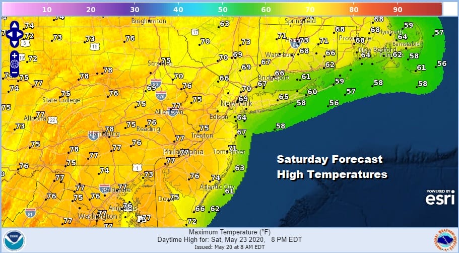
The area of rain weakens somewhat as it moves northeast so we won’t be getting the volume of rain that fell in the Carolinas to the Ohio Valley this week (5 inches or more in spots). However as the GFS shows we will see weak low pressure develop east of New Jersey and south of Long Island Saturday. This will likely keep clouds over us especially from the northern half of New Jersey north and east along with some showers. South and west of there there is a chance for some improvement as Saturday wears on.

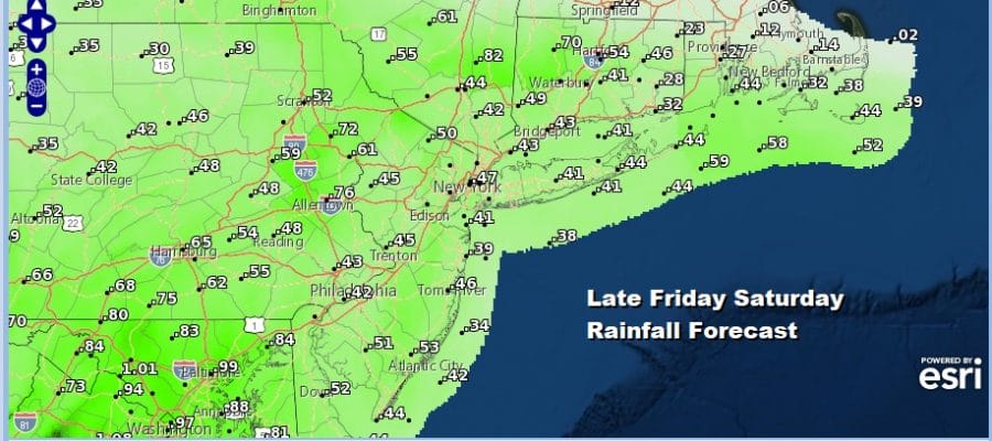
Rainfall amounts for Friday into Saturday are in the range of a quarter to about 4 tenths of an inch with slightly higher amounts to the south. Temperatures Saturday will have a bit of a range to them. Highs will be in the 60s east of NYC and into the 70s to the west and south especially if we get some improvement in sky conditions.
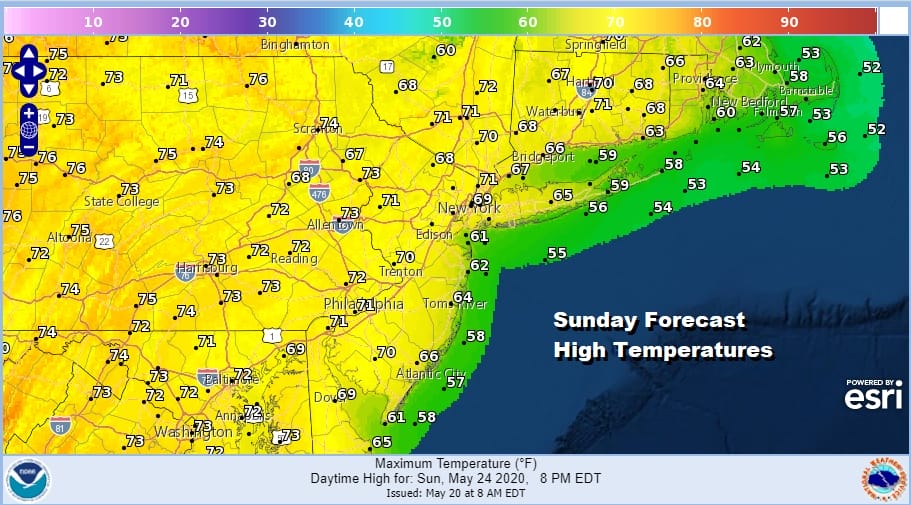
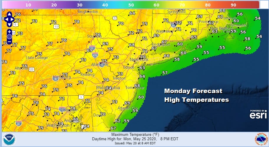
There is no change in our weather outlook for Sunday and Monday. Those will be the two better days this weekend with at least some sunshine both Sunday and Monday. Sunday’s highs will be in the upper 60s to lower 70s and Monday’s highs will be in the low to mid 70s. Two nice days out of three for Memorial Day weekend is not bad.
Next week we will see a trend to warmer temperatures with not much in the way of rain chances. A weak cold front might bring a couple of showers Wednesday night and another front perhaps Friday night or next Saturday. Otherwise the overall weather pattern next week will be quiet and much more like mid to late spring than it has been lately.
BE SURE TO DOWNLOAD THE FREE METEOROLOGIST JOE CIOFFI WEATHER APP &
ANGRY BEN’S FREE WEATHER APP “THE ANGRY WEATHERMAN!
MANY THANKS TO TROPICAL TIDBITS FOR THE USE OF MAPS
Please note that with regards to any severe weather, tropical storms, or hurricanes, should a storm be threatening, please consult your local National Weather Service office or your local government officials about what action you should be taking to protect life and property.


