Memorial Day Weekend Cloudy Saturday Slow Improvement By Monday
Our Memorial Day Weekend is underway with mainly cloudy conditions but there are some improving weather conditions on the edges. Low pressure is developing along the New Jersey shore and will be crawling eastward today and Sunday. This is creating an east west band of clouds with the southern edge breaking up in Southern New Jersey and Southern Pennsylvania southward while it is fairly solid northward into Southern New England. Heavy rain fell this morning in Southern Pennsylvania and Southern New Jersey. The rain is patchy so not everyone will be seeing rain into this afternoon.
SATELLITE

REGIONAL RADAR

Most of the rainfall amounts have been on the order of an inch to an inch and a half in some places. The arm of heavy rain is lifting slowly northeastward and showing up on local radars. There are also a few embedded thunderstorms in the mix as well. Rain is done south and west of Philadelphia but we are going to see it move through areas surrounding NYC as the day wears on.
LOCAL RADAR NEW YORK CITY

LOCAL RADAR PHILADELPHIA


Most temperatures are in the 60s and will be in the mid 60s to low 70s for the highs. The best chances for 70s will be south and west of Philadelphia where the rain is gone and clouds are trying to thin out. While the rain disappears late today and for the rest of the weekend we do have some issues for Sunday.
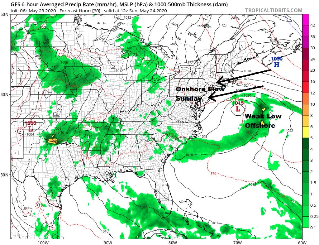
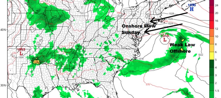
Sunday we will be dealing with the curse of the onshore flow which means we will probably be sitting in clouds all day long. Strong high pressure over Nova Scotia and a weak low east of the Delmarva Peninsula are combining to produce east northeast winds on Sunday. This will keep temperatures capped in the 60s and coastal areas may wind up having a tough time getting out of the 50s. No rain is forecast however since there is very little support for development of the low. The only issue might be some patchy drizzle that works its way in from offshore.
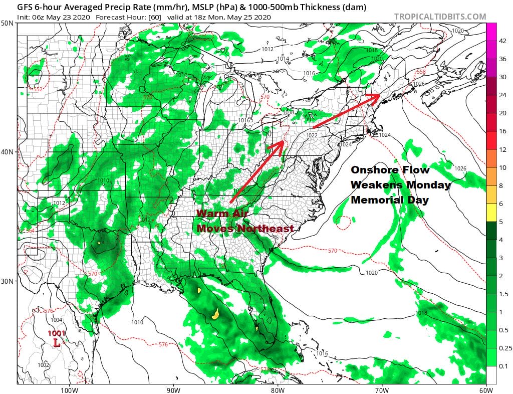
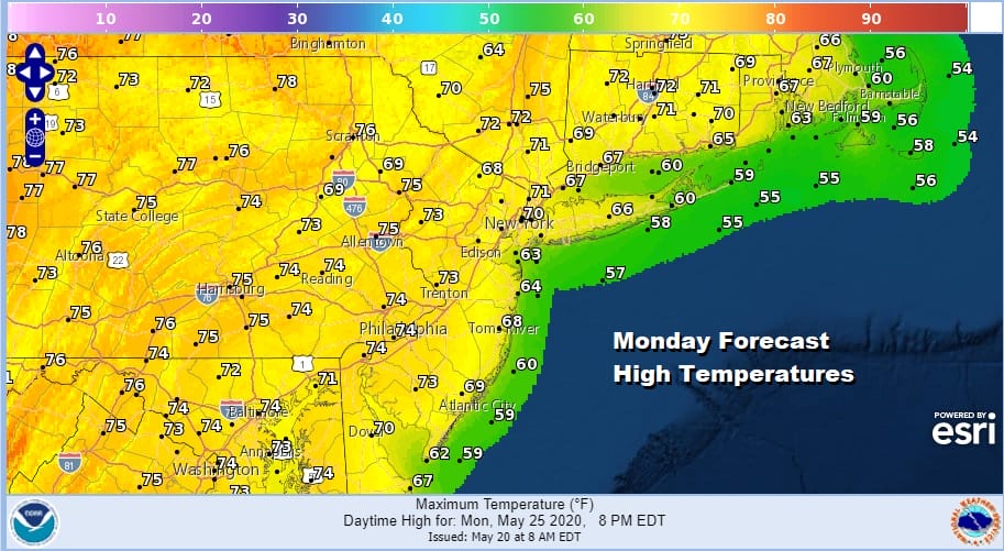
Monday Memorial Day sees the onshore flow relax as high pressure moves well out to the east and the weak low offshore falls apart. This should lead to slow improvement and warmer temperatures with clouds giving way to some sunshine. Highs should reach into the 70s in most places except of course right along the coast.
A warm weather pattern begins on Tuesday and lasts through Friday with some sunshine each day and warm temperatures. We should see highs reach in the to 80s each day with nighttime lows in the 50s Tuesday morning and warming into the 60s for the rest of the week. No rain is forecast until late Friday with the next cold front and a chance for showers and thunderstorms.
BE SURE TO DOWNLOAD THE FREE METEOROLOGIST JOE CIOFFI WEATHER APP &
ANGRY BEN’S FREE WEATHER APP “THE ANGRY WEATHERMAN!
MANY THANKS TO TROPICAL TIDBITS FOR THE USE OF MAPS
Please note that with regards to any severe weather, tropical storms, or hurricanes, should a storm be threatening, please consult your local National Weather Service office or your local government officials about what action you should be taking to protect life and property.


