Maria Steady NNW Course 115 mph Winds Coastal North Carolina Threat?
Maria Steady NNW Course 115 mph Winds
Coastal North Carolina Threat?
NATIONAL HURRICANE CENTER 5PM ADVISORY
…MARIA CONTINUES NORTH-NORTHWESTWARD…
…INTERESTS ALONG THE CAROLINA AND MID-ATLANTIC COASTS SHOULD
MONITOR THE PROGRESS OF MARIA…
SUMMARY OF 500 PM EDT…2100 UTC…INFORMATION
———————————————-
LOCATION…26.3N 72.5W
ABOUT 285 MI…460 KM E OF GREAT ABACO ISLAND
ABOUT 640 MI…1030 KM SSE OF CAPE HATTERAS NORTH CAROLINA
MAXIMUM SUSTAINED WINDS…115 MPH…185 KM/H
PRESENT MOVEMENT…NNW OR 345 DEGREES AT 9 MPH…15 KM/H
MINIMUM CENTRAL PRESSURE…950 MB…28.06 INCHES
WATCHES AND WARNINGS
——————–
CHANGES WITH THIS ADVISORY:
None.
SUMMARY OF WATCHES AND WARNINGS IN EFFECT:
There are no coastal watches or warnings in effect.
Interests along the Carolina and Mid-Atlantic coasts should monitor
the progress of Maria. Tropical storm or hurricane watches may be
needed for a portion of the coast on Sunday.
DISCUSSION AND 48-HOUR OUTLOOK
——————————
At 500 PM EDT (2100 UTC), the eye of Hurricane Maria was located
near latitude 26.3 North, longitude 72.5 West. Maria is moving
toward the north-northwest near 9 mph (15 km/h), but a turn toward
the north is expected by tonight. A northward motion with a
decrease in forward speed is forecast to then continue through
Monday. On the forecast track, Maria will move away from the
Bahamas and offshore of the southeastern coast of the United
States.
Maximum sustained winds are near 115 mph (185 km/h) with higher
gusts. Maria is a category 3 hurricane on the Saffir-Simpson
Hurricane Wind Scale. A gradual weakening trend is expected to
begin late Sunday or Monday.
Hurricane-force winds extend outward up to 60 miles (95 km) from the
center, and tropical-storm-force winds extend outward up to 240
miles (390 km).
The minimum central pressure from a NOAA Hurricane Hunter plane is
950 mb (28.06 inches).
SATELLITE LOOP

Maria has remained on a steady north northwest course all afternoon and it continues to move into the open waters of the Atlantic. The pressure has dropped a little to 950 mb but the winds remain about the same based on the latest Air Force recon report. Maria seems to be edging a little further to the west which may keep it in warmer water as the colder water in the wake of Jose lies just to the northeast.
Weather models this afternoon continue to suggest a threat for the Outer Banks of North Carolina. As of right now none of the major global models bring the center on land. Below is the map of the GFS ensembles. If you look at the small number it denotes the pressure and postion of each ensemble member.
GFS ENSEMBLES CLICK TO ANIMATE
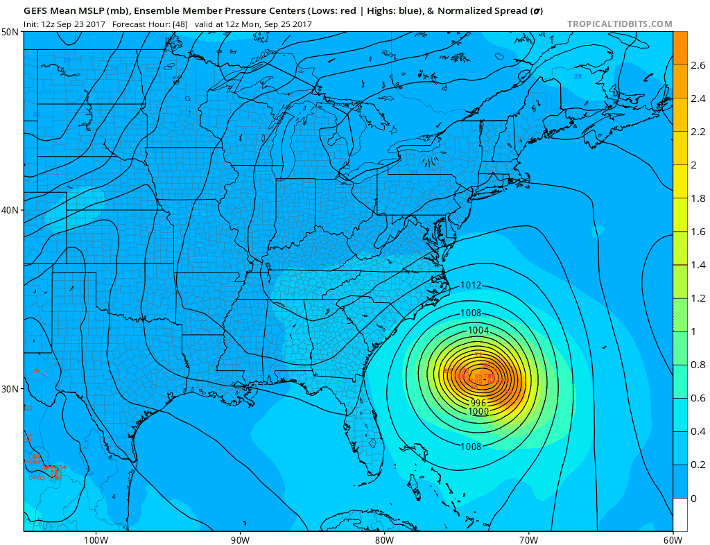
You can see that there is some variation in where each member takes and there is bit of a spread with some taking Maria very close to the coast and others further offshore. A few members take Maria inland into North Carolina.The isobars show the center of the average of all the positions. All are close enough to put the Outer Banks at risk for tropical storm force winds beginning Monday and lasting into Wednesday.
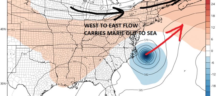
GFS JET STREAM THURSDAY SEPTEMBER 28TH 8AM
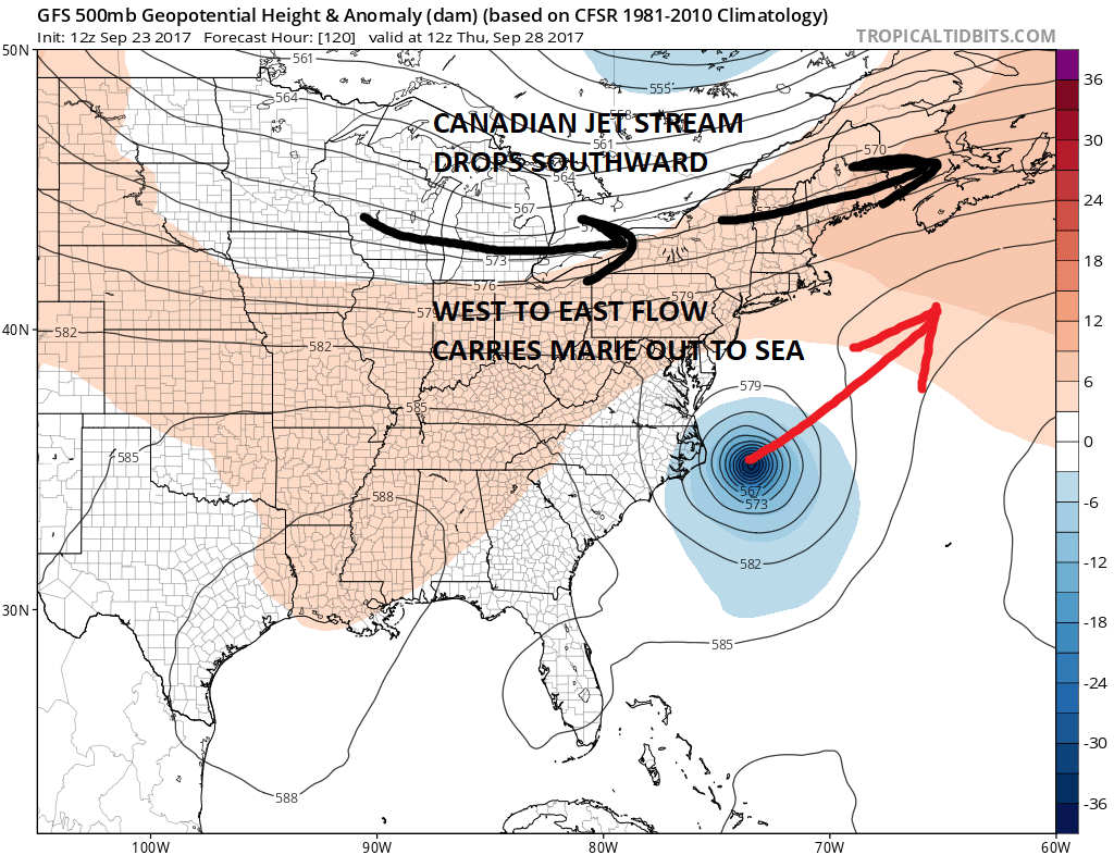
We can continue to say that given that the northern part of the jet stream will be dropping southward into the Northeast that a track straight up the East Coast is unlikely. The upper flow is a broad west to east wind which prevents Maria from getting much further north than the latitude of Virginia. Even a track inland would probably then result in an east northeast motion and out to sea well south and east of us. Only if the jet stream to the north takes longer to drop southward would Maria have a chance to get further north, or Maria suddenly speeds up its forward motion come toward the coast faster. This too seems unlikely given the weak upper air steering pattern around the upper high. If models remain consistent a tropical storm watch could be required for the Outer Banks perhaps as early as Sunday afternoon or evening.
FiOS1 News Weather Forecast For Long Island
FiOS1 News Weather Forecast For New Jersey
FiOS1 News Weather Forecast For Hudson Valley