Major Storm to the Great Lakes,
Heavy Rain, Wind, Coastal Flooding Tonight Into Saturday

Major Storm to the Great Lakes,
Heavy Rain, Wind, Coastal Flooding Tonight Into Saturday
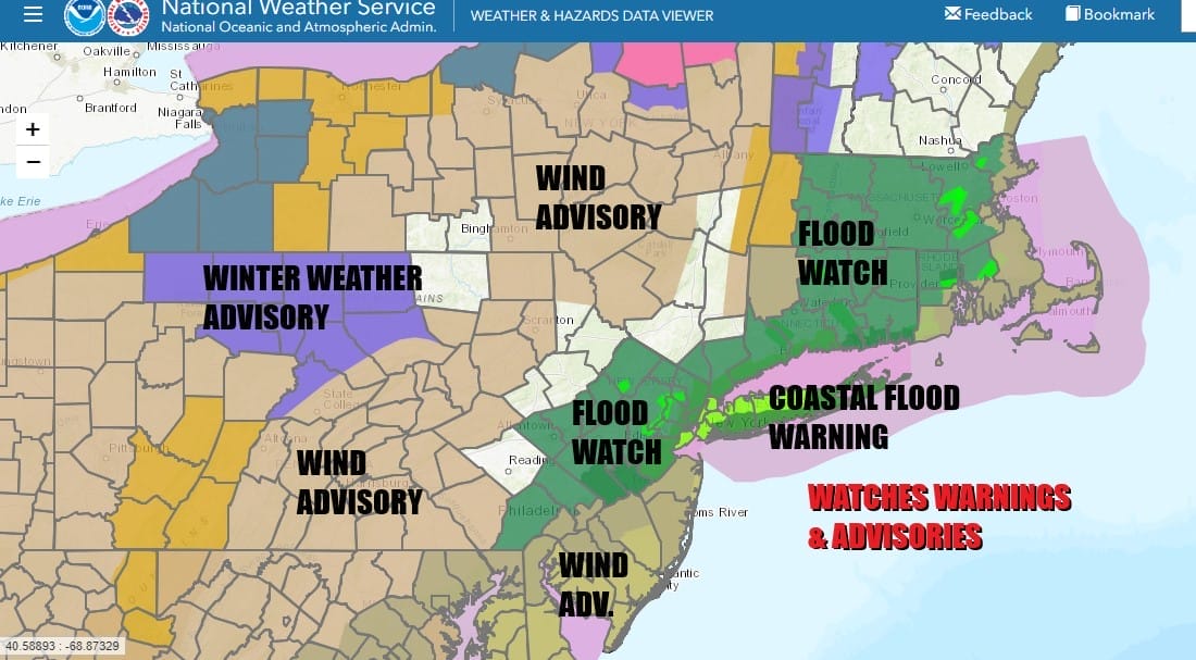
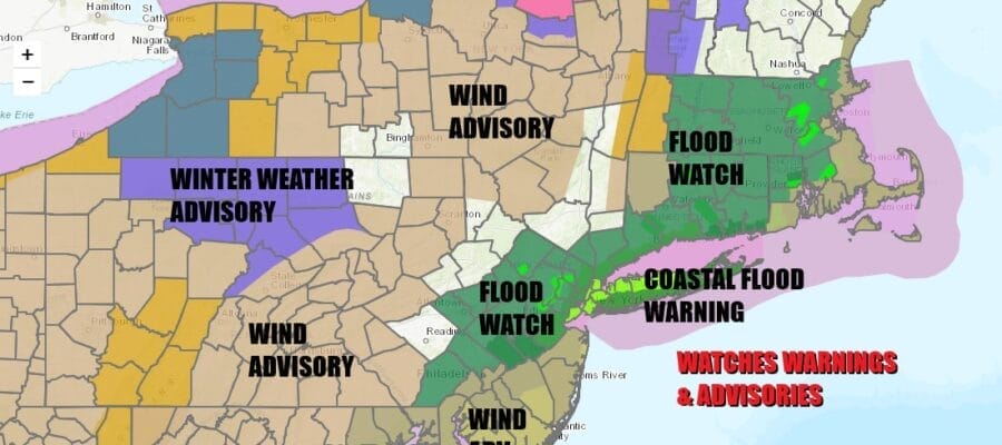
Major storm number two gets underway today and it begins with clouds increasing. Low presssure is coming out of the Southern Plains and running to the Great Lakes, intensifying into a major storm in the process. This storm will play out in much the same way that Tuesday’s storm did. We have all sorts of watches up from Flood Watches, to Wind Advisories, to Coastal Flood Warnings. Coastal residents should make note of the high tide times from Southern New England to Delaware as moderate to major coastal flooding is forecast tonight into Saturday morning high tides.

Flood Watches are up for heavy rain however we think that rainfall will be about 30 to 50 % lower than from the Tuesday storm which puts most places in a 1 to 2 inch range. Rainfall amounts will tend to be lower as you head south of NYC and higher as you head northeast. Rivers and streams remain near bankful and it would not take much to create flooding. The upside as we do not have a foot of snow cover this time around to that helps somewhat to reduce flood potential.
SATELLITE WITH LIGHTNING STRIKES

WEATHER RADAR

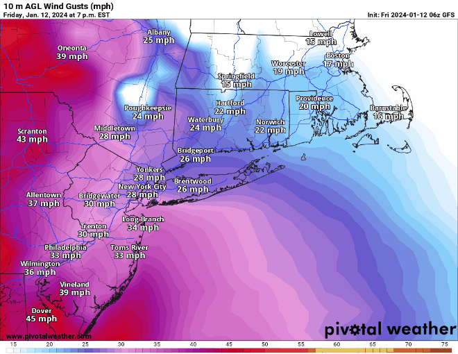
Weather conditions will slowly deteriorate as the day wears on though we suspect that rain will hold off until after sunset and the advance from southwest to northeast. Winds will start to pick up from the Southeast this evening. The strongest winds will be from 10pm Friday through 7am Saturday. Gusts inland will reach 30 to 40 mph at times while coastal gusts will reach 50 mph or more in some places.
overnight rain and wind will continue until daybreak as the rain ends from west to east and a cold front passes. Then we should see gradual improvement as we go through Saturday. Leftover clouds will give way to some breaks of sunshine. Temperatures which tonight will be climbing into and in some cases through the 50s will begin to fall off during the day Saturday as colder air comes on the back side. Temperatures later Saturday will gradually ease into the 40s as the day wears on and the drop into the 20s at night. Sunday begins a stretch of cold weather though we will have sunshine and a gusty wind. Highs will be just into the 30s. While winds will remain strong and gusty Saturday and Sunday they will be off their highs of Friday night.

This storm system is very important to the fate of the overall pattern. It will move into Eastern Canada and weaken, rotating back westward across Southern Canada over the weekend and early next week. This pulls the jet stream pattern west and south. The next storm system will be moving across the Deep South Sunday night into Monday night bringing snow and wintry precipitation to areas from Northern Louisiana and Arkansas, east to Tennessee, Northern Mississippi, Northern Alabama, and North Geogia. That low will turn up the East Coast and should track far enough offshore.
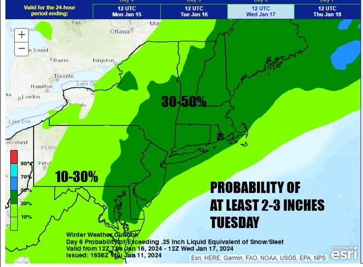
The Weather Prediction Center has a 30 to 50 percent chance of at least a few inches of snow from Maryland to Maine including all the big cities in the I-95 Corridor for Tuesday into Tuesday night. That’s a first for this winter to see a forecast like this for the Mid Atlantic and Northeast. There is still a high degree of uncertainty among the weather models regarding this system though I tend to think we are going to see some snow from this come Tuesday. We will be discussing this further tonight on the Joe & Joe Weather Show Podcast at 7:35pm Eastern Time on Youtube.
BE SURE TO DOWNLOAD THE FREE METEOROLOGIST JOE CIOFFI WEATHER APP &
ANGRY BEN’S FREE WEATHER APP “THE ANGRY WEATHERMAN!
MANY THANKS TO TROPICAL TIDBITS FOR THE USE OF MAPS
Please note that with regards to any severe weather, tropical storms, or hurricanes, should a storm be threatening, please consult your local National Weather Service office or your local government officials about what action you should be taking to protect life and property.
(Amazon is an affilate of Meteorologist Joe Cioffi & earns commissions on sales.)


