Major Storm Heavy Rain Strong Winds,
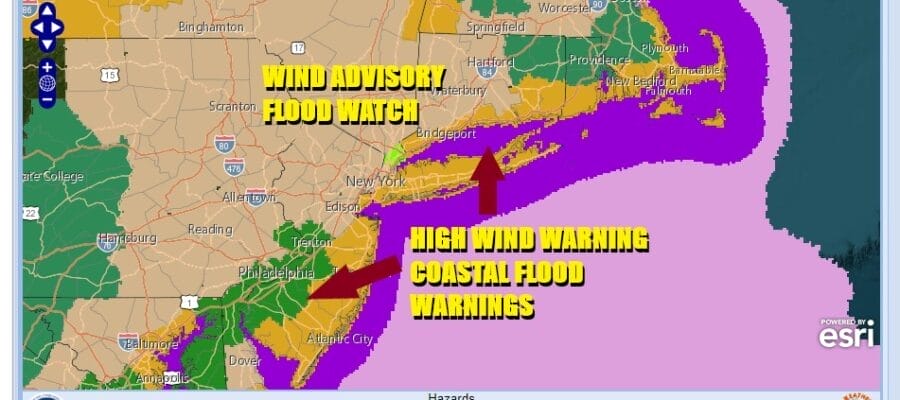
Flood Watch High Wind Coastal Flood Warning

Major Storm Heavy Rain Strong Winds,
Flood Watch High Wind Coastal Flood Warning
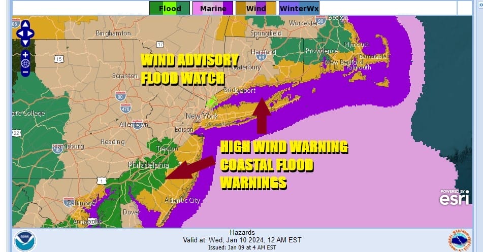
We have a busy day ahead as the first of two major storms plays through. We have Flood Watches up for all of Eastern Pennsylvania to Southern New England as heavy rain will develop late today and last into the early morning hours Wednesday. Rainfall amounts of 2 to 3 inches are likely. Areas inland have up to a foot of snow on the ground that will all melt today and tonight and that will add to flooding concerns.

Next we have High Wind Warnings for coastal areas that extend from Southeast Virginia northward to Coastal and Southern New Jersey, Staten Island, Long Island, Coastal Southern and Southeastern New England. Wind Gusts will reach 50 to 60 mph in a widespread area tonight and some gusts of 70 mph are possible in some places. Inland areas are under a wind advisory and gusts of 40 mph or more are possible up and down the Eastern Seaboard from Maine to Georgia! Areas of moderate to major coastal flooding are forecast for high tides today and tonight and we have Coastal Flood Warnings already posted for parts of New Jersey as well as Long Island.

Weather conditions will deteriorate rapidlyt today as rain move up the coast from south to north and then becomes heavy at times going into this evening. Look for satellite and radars to show expansion of the rain coverage area and it should cover all of Eastern Pennsylvania to Southern New England by mid to late afternoon. At this point winds will start increasing and approaching gale force along the coast. Temperatures will be on the rise through the 40s and into the 50s tonight.
SATELLITE WITH LIGHTNING STRIKES

WEATHER RADAR

The worst of it will likley be in a stretch from about 7pm to 3am from west to east the excact time will depend on the approaching cold front. Low pressure heads to the Great Lakes and then moves northeast into Southeastern Canada. The trailing cold front is likely to produce a squall line of thunderstorms from north to south and the models are showing a very impressive line of storms that runs up and down the Eastern Seaboard. There is some risk for isolated severe thunderstorms in this squall line.

The rain should end from west to east rather quickly and then we see winds turn from southeast to west. They will remain strong and gusty with clouds giving way to some sunshine Wednesday though some areas will see lots of leftover clouds for awhile. Winds will gust over 40 mph over a wide area and wind advisories will likely continue all day. Temperatures will settle in the 40s.

There is no rest for the weary as we will get a one day break Thursday and then another major storm comes out of the Southern Plains and heads to the Great Lakes. This storm takes a similar track as tonight’s storm system and we may have similar weather outcomes with rain wind and coastal flooding later Friday into Saturday.
BE SURE TO DOWNLOAD THE FREE METEOROLOGIST JOE CIOFFI WEATHER APP &
ANGRY BEN’S FREE WEATHER APP “THE ANGRY WEATHERMAN!
MANY THANKS TO TROPICAL TIDBITS FOR THE USE OF MAPS
Please note that with regards to any thevere weather, tropical storms, or hurricanes, should a storm be threatening, please consult your local National Weather Service office or your local government officials about what action you should be taking to protect life and property.
(Amazon is an affilate of Meteorologist Joe Cioffi & earns commissions on sales.)


