Major Storm Heads East With Widespread Severe Storms, Tornadoes & Strong Winds
A major storm is developing in the Plains and heading for the Great Lakes, strengthening along the way. This storm is very powerful and is producing blizzard conditions from South Dakota, Minnesota, Iowa & Wisconsin. 2 feet or more of snow is forecast. Across the Mississippi River Valley as well as the Ohio and Tennessee Valley and the Deep South, it will be about widespread severe thunderstorms and elevated tornado risk today and overnight. None of this is an issue for the Eastern US, specifically for Eastern Pennsylvania to Southern New England during today however we will begin to feel impacts from this storm system tonight and especially Monday which will be loaded with showers, thunderstorms, strong winds and the potential for severe thunderstorm and possible tornadoes.
SATELLITE WITH LIGHTNING STRIKES
WEATHER RADAR
Today we will be watching a warm front setting up and for now it seems that warm front is setting up overhead across Eastern Pennsylvania to Southern New England. Rain is developing north of the warm front and in some areas well to the north we have a little bit of snow. Look for increasing clouds today with temperatures topping in the upper 40s and lower 50s and probably holding there overnight as winds turn east and then south. Areas of rain and some embedded scattered thunderstorms will develop after 10pm tonight and last into daybreak Monday.
Monday is going to be a bit of a rough day as the major storm moves across Southern Canada with a trailing strong cold front. Severe weather risks Monday will be widespread and we have a “moderate risk” or a 45 percent chance for severe thunderstorms in the red area from Central Maryland south through Virginia and into North Carolina. For Eastern Pennsylvania to Southern New England we are going to be on the northern flank and we have enhanced risk (30 percent) across South Central and Southeast Pennsylvania into a small portion of Southwest New Jersey. Slight risk extends further north into New Jersey and Southern New York. Marginal risk for isolated severe thunderstorms extends east to the Hudson Valley, New York City, and westernmost Long Island.
We also have elevated tornado risk of up to 15 percent in Maryland and Virginia. That is not a low number. EF-1 tornadoes (winds up to 115 mph) are certainly possible and there is the chance we could see tornadoes at strength EF-2 or higher (winds up to 135 mph) in the moderate risk zone. Areas to the north in Eastern Pennsylvania and New Jersey are at 2 to 5 percent risk for isolated tornadoes spinning up. Rain will be heavy at times Monday though there will be some short breaks from mid morning to mid afternoon. Then the cold front arrives with the heaviest thunderstorms moving through Monday evening. We are expecting wind advisories to be posted for Monday at some point later today or tonight.
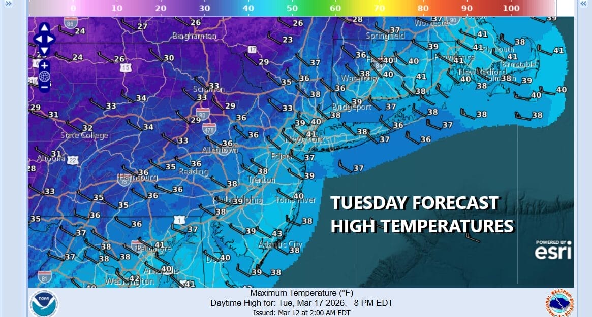
Once the front passes weather conditions will improve and we will have sunshine for Tuesday, Saint Patrick’s Day. However it is going to be a very cold day with temperatures just in the 30s to at best near 40 degrees for highs plus there will be a persistent wind that will make it feel 10 degrees colder. No rain or snow is forecast. Cold weather conditions will continue through Wednesday before we see temperatures moderate some late in the week.
BE SURE TO DOWNLOAD THE FREE METEOROLOGIST JOE CIOFFI WEATHER APP &
ANGRY BEN’S FREE WEATHER APP “THE ANGRY WEATHERMAN!
MANY THANKS TO TROPICAL TIDBITS FOR THE USE OF MAPS
Please note that with regards to any severe weather, tropical storms, or hurricanes, should a storm be threatening, please consult your local National Weather Service office or your local government officials about what action you should be taking to protect life and property.