
DOWNLOAD MY NEW FREE JOESTRADAMUS WEATHER APP FOR ANDROID
THE APP IS ABSOLUTELY FREE TO ALL BUT CONSIDERING SUBSCRIBING TO PATREON FOR A WEATHER EXPERIENCE FREE OF ADS, EXCLUSIVE VIDEOS FOR MEMBERS ONLY AND MUCH MORE…STARTS AT $2 A MONTH..MESSAGE ME AT ANY TIME
Major Snow Storm Northern Plains Warm Rain Here Friday
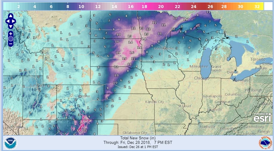
The Northern Plains is preparing for a major snow storm tonight into Thursday night. Low pressure is developing in West Texas and it is taking a track northeastward to the Great Lakes while strengthening. Lots of Gulf moisture is getting involved with this and there is a solid push of cold air on the northwest side of the storm to produce a rather large area of 12 inches or more of accumulation. Numerous Winter Storm Warnings are posted from Western Kansas up to the Dakotas and Northern Minnesota.
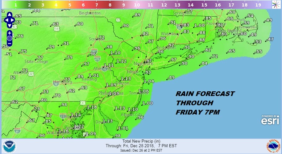
When a snowstorm is going on in the Plains it means the upper air set up is for warm air to surge into the Eastern US and we will be seeing that take place Friday as the low moves into Southeastern Canada, Gulf moisture will be flooding the east with rain on the order of about an inch to an inch and a quarter. The map below shows the rainfall amounts forecast through Friday evening. Rain will arrive during the early morning hours on Friday and it should be done by Friday evening. There might be some convection in the mix so some areas could see higher amounts.
Before we get to Friday we have tonight and tomorrow which should be fine. The satellite loop shows a little stick of cloud cover that is sitting over Northern New Jersey and Long Island while there has been a fair amount of sunshine on either side of these clouds. The clouds should thin out later this evening and skies should go mostly clear tonight with temperatures in the 20s to lower 30s. Radars are quiet over us and will remain so into Thursday evening.
EASTERN SATELLITE

REGIONAL RADAR

Temperatures on Thursday will be chilly with sunshine giving way to arriving clouds with highs just into the 40s. Then as the warm front with the storm heads our way temperatures Thursday night will be slowly rising as rain arrives in the early morning hours. Then Friday it is cloudy with rain occasionally heavy with highs in the mid 50s to lower 60s in most places. The front passes and weather conditions improve on Saturday. Some sunshine with some leftover mild air early means highs in the low to mid 50s. Colder air begins to arrive later Saturday into Sunday and we should be in the 20s to low 30s by Sunday morning.
Uncertainty Grows For Sunday
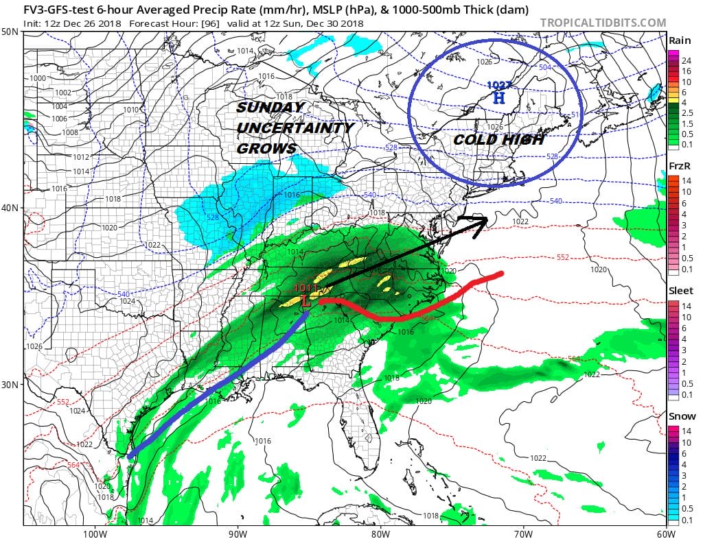
The front with this system gets hung up across the Gulf States and a wave develops on it and moves Northeastward. There is a cold high sitting in Northern New England and that cold air bleeds southward Saturday night and on Sunday as the low approaches. The problem here is that weather models are trying to handle all sorts of energy running around in the flow. The Parallel GFS model ( which will replace the current GFS in January) is very bullish with this system as it brings precipitation northward into the cold air and produces snow for much of our area from Eastern Pennsylvania to Central New Jersey & Southern New England. However we don’t see much agreement at all with the other models. Some bring precipitation here while others keep this week and suppress it southward. We will discuss this system in detail later today once we get a firm handle on what exactly is going on. We will also discuss the major pattern change that is underway as we head into early January which also part of the process.
MANY THANKS TO TROPICAL TIDBITS FOR THE USE OF MAPS
Please note that with regards to any tropical storms or hurricanes, should a storm be threatening, please consult your local National Weather Service office or your local government officials about what action you should be taking to protect life and property.