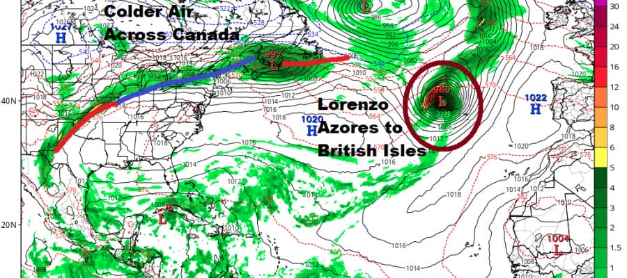
Lorenzo Headed For Azores & Possibly Ireland England Scotland
Hurricane Lorenzo has reached its peak intensity early on Friday when top winds were over 140 mph. Since then the hurricane has deteriorated somewhat but still remains a major hurricane. It is also going to be important to our long range pattern as it sets off series of changes across the northern latitudes across Europe and Asia and ultimately to North America. We will begin to see a series of air masses moving southeast from Canada ushering in some real autumn weather beginning later next week.
LORENZO SATELLITE

First thing first is a northerly course that will bring Lorenzo close to the Azores late Tuesday night or Wednesday and then from there it will get involved with a big storm in the North Atlantic and pass close to Ireland, England & Scotland late next week.

With the departure of Lorenzo it looks like the tropics will take a breather after a rather active period that began in the second half of August. This stretch produced 3 major hurricanes (Dorian, Humberto, & Lorenzo) and 7 other tropical storms including Imelda which formed right off the coast of Southeast Texas and dumped over 40 inches of rain in some cities between Houston and Port Arthur. October can still produce major hurricanes though the area of development does begin to shift away from the deep tropical Atlantic and moves further west over time. The first half of the month can be busy sometimes and then activity does tend to decrease substantially in the second half of the month and into November. One should not forget that it was in late October that we saw Hurricane Sandy hit our area so while the odds for and east coast storm do decrease, they certainly do not go to zero.
MANY THANKS TO TROPICAL TIDBITS FOR THE USE OF MAPS
Please note that with regards to any tropical storms or hurricanes, should a storm be threatening, please consult your local National Weather Service office or your local government officials about what action you should be taking to protect life and property.