
Long Range Weather Models Aligned

MENTION JOE CIOFFI AND GET A 5% DISCOUNT
We have been getting hints of a short term pattern flip that will occur later next week. All long range weather models in their outlook line up unusually close to each other. That is pretty remarkable. Models are reacting to a strong Eastern Pacific Oscillation index which crashes off the wall negative as we turn the calendar from March to April.
Long Range Weather Models Aligned Teleconnection Indices
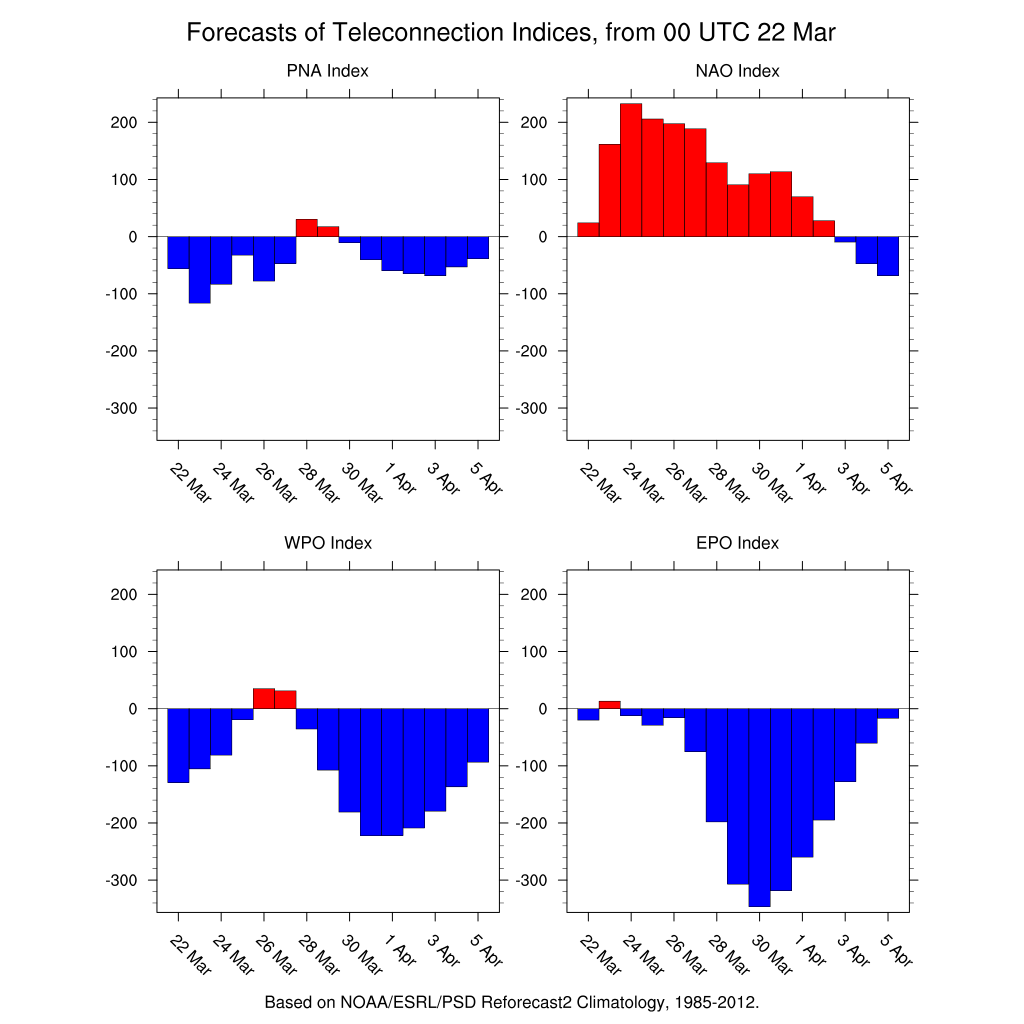
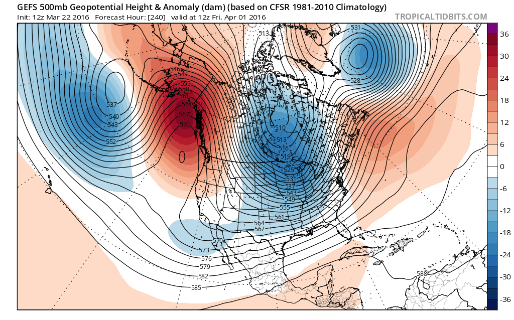
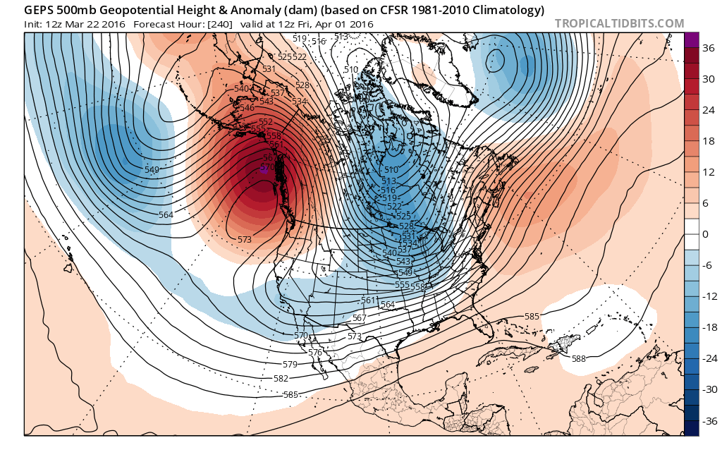
The strong negative East Pacific Oscillation creates a strong ridge in the northeast Pacific and drives a strong polar flow from north to south deep into the United States. The ensemble means of all three weather models show how in line they are for this to happen.
Long Range Weather Models Aligned Ensemble Forecasts

Now this means that below to much below normal temperatures will be impacting the United States for a few days at least. Now this cold shot will probably last no more than a few days before the trough pulls out to some degree. Also there is no indication at this point that there is any kind of storm threat in this time frame. The trough and how it sets up would probably not be favorable for any kind of snow here. As we stated yesterday that part of the equation is a short term issue and the setup would have to be absolutely perfect. We saw what just happened a few days ago when the atmosphere is less than perfect. Also note the other indicators above are not in favorable positions for snow anyway. I believe the main emphasis will be on the cold for a 3 or 4 day period from April 2nd through around April 5th. Based on what we see today, temperatures will average about 5 to 10 degrees below normal which says 40s to near 50 for daytime highs and nights in the 20s and lower 30s. Of course this is only a broad brush that is painting this picture at the moment. Some models are more aggressive with the cold than others. The European appears to be the most aggressive at this point. We will watch to see how this evolves over the next several days.
FiOS1 News Weather Forecast For Long Island
FiOS1 News Weather Forecast For New Jersey
FiOS1 News Weather Forecast For Hudson Valley
NATIONAL WEATHER SERVICE SNOW FORECASTS
LATEST JOESTRADAMUS ON THE LONG RANGE

NOMINATED FOR AN APPY AWARD FOR BEST WEATHER APP!!
Weather App

Don’t be without Meteorologist Joe Cioffi’s weather app. It is really a meteorologist app because you get my forecasts and my analysis and not some automated computer generated forecast based on the GFS model. This is why your app forecast changes every 6 hours. It is model driven with no human input at all. It gives you an icon, a temperature and no insight whatsoever.
It is a complete weather app to suit your forecast needs. All the weather information you need is right on your phone. Android or I-phone, use it to keep track of all the latest weather information and forecasts. This weather app is also free of advertising so you don’t have to worry about security issues with your device. An accurate forecast and no worries that your device is being compromised.
Use it in conjunction with my website and my facebook and twitter and you have complete weather coverage of all the latest weather and the long range outlook. The website has been redone and upgraded. Its easy to use and everything is archived so you can see how well Joe does or doesn’t do when it comes to forecasts and outlooks.
Just click on the google play button or the apple store button on the sidebar for my app which is on My Weather Concierge. Download the app for free. Subscribe to my forecasts on an ad free environment for just 99 cents a month.
Get my forecasts in the palm of your hand for less than the cost of a cup of Joe!
![]()

