Long Range Looks Cooler Than Average Overall

Long Range Looks Cooler Than Average Overall
Since the new normal in this world we live in is that 90 degree days have never ever happened before (see mid May), looking at the long range I really don’t see anything that suggests prolonged hot weather anytime soon. Either they will be cut off after a couple of days by some sort of back door cold front, or the overall pattern will favor weather systems moving along from west to east so cold fronts will cut the heat off just as it gets going.
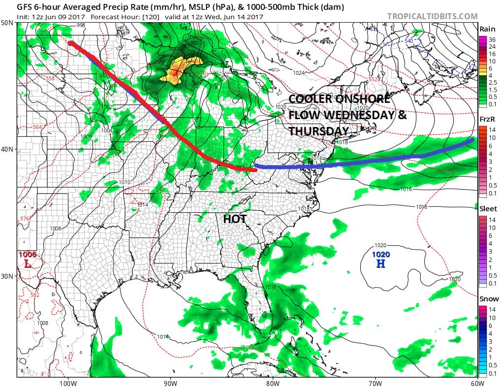
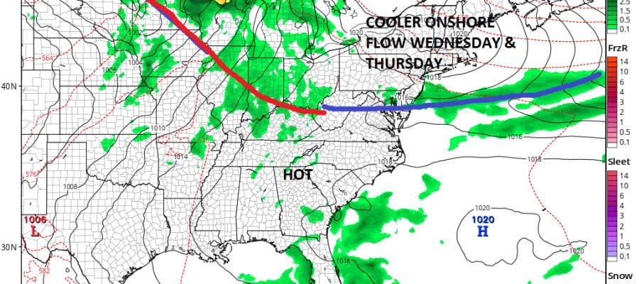
The stretch of 90 plus temperatures about to arrive will last from Sunday through Tuesday of next week. This will be 3 days of 90 plus which meets the dumb down rule for a heatwave (old definition was 5 days). All weather models show a back door front pushing through the area from north to south late Tuesday or Tuesday evening. This means that Wednesday and Thursday will be cooler especially near coastal areas as winds will be from the east. ALL WEATHER MODELS show this backdoor and latest runs show the push of cool air to be a bit stronger than previously modeled.
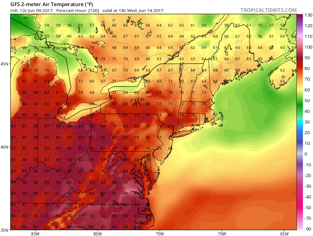
LONG RANGE WEDNESDAY FORECAST HIGHS 6/13/2017
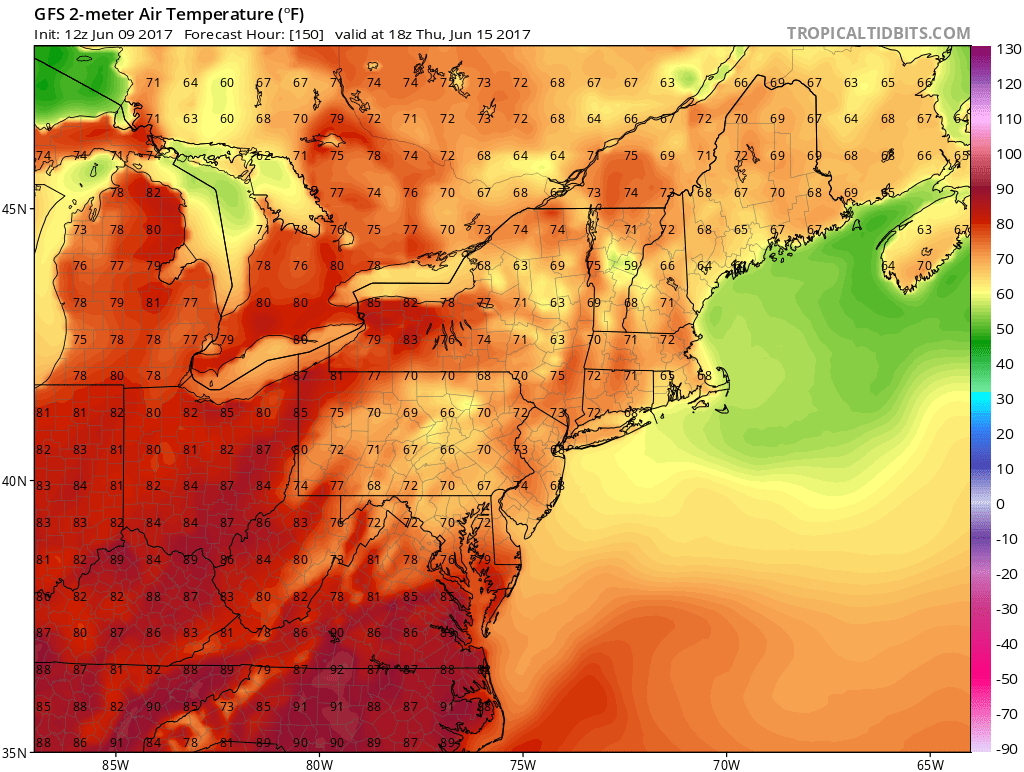
LONG RANGE THURSDAY FORECAST HIGHS 6/14/2017
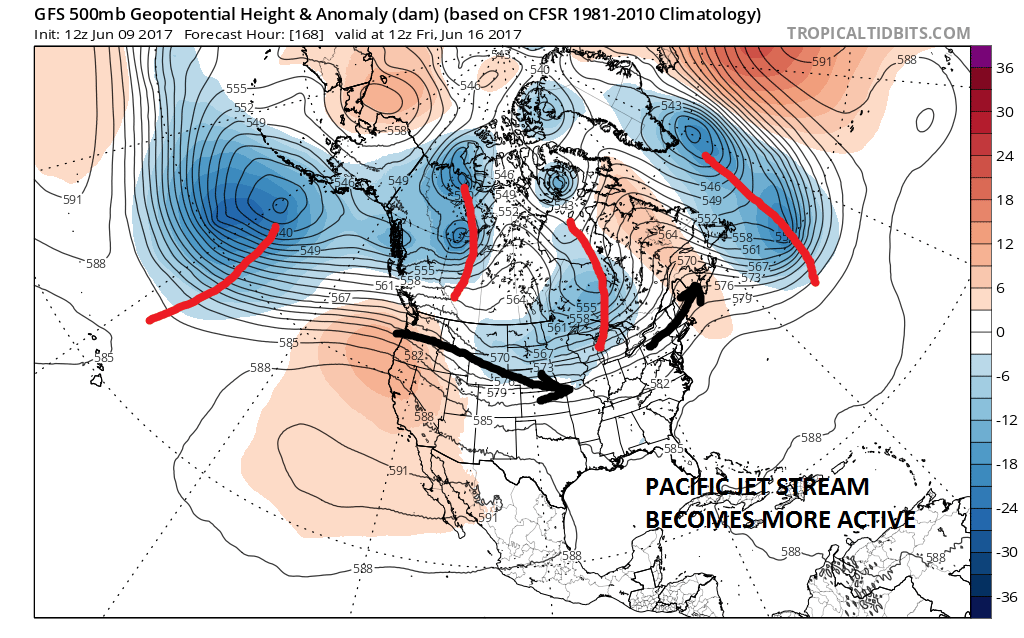
Now as we adventure longer term as we look at the upper air forecasts it appears that we will have an active Pacific jet stream developing from west to east across the United States. This means 2 things for us. In the winter the strong Pacific jet means warmer than average. This time of year if the jet is strong enough it means average or even below average temperatures especially if there is an active jet in Southern Canada. This appears to be the case. That means that cold front could be pushing through every 2 to 3 days and that keeps it from getting too hot for too long.
LONG RANGE JET STREAM NEXT FRIDAY 06/16/2017
There are two other things that we will be looking at beyond next week. The first will be whether the tendency for some sort of high latitude blocking to appear again. The second is whether there could be some sort of tropical storm development in the Northwest Caribbean or Gulf of Mexico. The upper air pattern developing across the tropics would seem to suggest that something developing in the seasonally favorable area of the Northwest Caribbean or SW Gulf of Mexico is possible. Some weather models have been picking up on this in their long range views for the last week or so.
MANY THANKS TO TROPICAL TIDBITS FOR THE WONDERFUL USE OF THE MAPS

GET JOE A CIGAR IF YOU LIKE!
LANDSCAPE COMPANIES FOR YOUR SPRING SUMMER FALL NEEDS
LONG ISLAND ROCKLAND COUNTY Connecticut

![]()

ROCKLAND COUNTY TRI STATE SNOW REMOVAL JOHNSTOWN PA


FiOS1 News Weather Forecast For Long Island
FiOS1 News Weather Forecast For New Jersey
FiOS1 News Weather Forecast For Hudson Valley
NATIONAL WEATHER SERVICE SNOW FORECASTS
LATEST JOESTRADAMUS ON THE LONG RANGE
Weather App

Don’t be without Meteorologist Joe Cioffi’s weather app. It is really a meteorologist app because you get my forecasts and my analysis and not some automated computer generated forecast based on the GFS model. This is why your app forecast changes every 6 hours. It is model driven with no human input at all. It gives you an icon, a temperature and no insight whatsoever.
It is a complete weather app to suit your forecast needs. All the weather information you need is right on your phone. Android or I-phone, use it to keep track of all the latest weather information and forecasts. This weather app is also free of advertising so you don’t have to worry about security issues with your device. An accurate forecast and no worries that your device is being compromised.
Use it in conjunction with my website and my facebook and twitter and you have complete weather coverage of all the latest weather and the long range outlook. The website has been redone and upgraded. Its easy to use and everything is archived so you can see how well Joe does or doesn’t do when it comes to forecasts and outlooks.
Just click on the google play button or the apple store button on the sidebar for my app which is on My Weather Concierge. Download the app for free. Subscribe to my forecasts on an ad free environment for just 99 cents a month.
Get my forecasts in the palm of your hand for less than the cost of a cup of Joe!
![]()