Long Island Weather Improving This Afternoon
Heat Humidity On The Way Tuesday Wednesday

Weather in 5/Joe & Joe Weather Show Latest Podcast
Long Island Weather Improving This Afternoon Heat Humidity On The Way Tuesday Wednesday
Clouds lingered for awhile this morning but we seem to be finally seeing some sunshine developing as low pressure to the northeast moves further away and the upper trough over the Northeast finally begins to lift out. You can expect to see increasing amounts of sunshine for this afternoon as temperatures make it back into the 70s. Humidity levels are reasonable making for a rather cool 4th of July but I’m sure most will make the best of it.
SATELLITE

WEATHER RADAR

Rain on the radar is over Maine and east of Boston. Those echoes are rotating counterclockwise around an upper low that is heading to the Gulf Of Maine. Radars to the west and south a quiet. There is the slight chance that a pop up shower could appear later on but the chances of Long Island seeing anything are very low and even if one happens it will be isolated and short lived.

No issues are expected tonight as skies should be partly to mostly clear. It will be a low humidity ac off kind of night. Most lows will be in the low to mid 60s. Monday will be partly to mostly sunny, warmer and a little more humid and south winds take over. Highs will be in the low to mid 70s primarily due to an ocean wind.

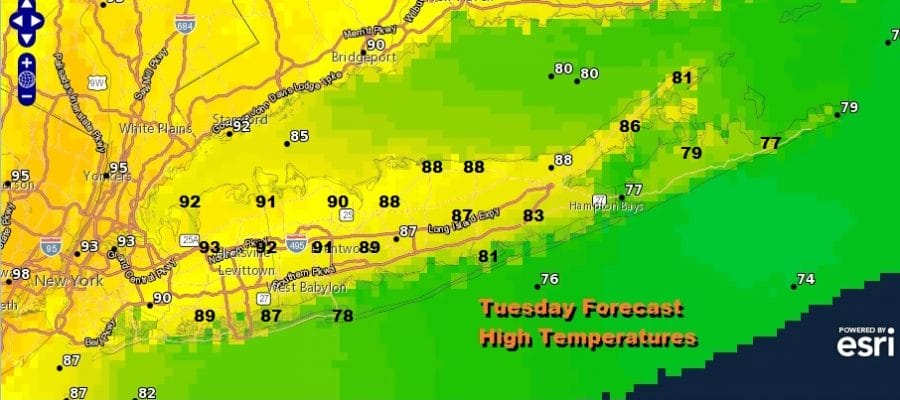
Tuesday see’s a return to heat and humidity with sunshine taking highs to the upper 80s and lower 90s with 70s to near 80 at the beaches. We will leave in the outside chance there could be a pop up shower or thunderstorm. Wednesday will be another hot and very humid day with highs reaching into the 90s in most places away from the ocean.

Wednesday starts the approach of an upper trough and cold front so there is the chance for a thunderstorm in the evening. More numerous thunderstorms are possible Thursday as the front approaches and makes its move through Long Island Thursday night. Also part of the equation will be what happens to Tropical Storm Elsa. Weather models are not very bullish with the system and it seems the moisture gets absorbed by the cold front. That could enhance some of the rain here but it is still a long way off. Either way weather conditions improve on Friday and going into next weekend.
BE SURE TO DOWNLOAD THE FREE METEOROLOGIST JOE CIOFFI WEATHER APP &
ANGRY BEN’S FREE WEATHER APP “THE ANGRY WEATHERMAN!

MANY THANKS TO TROPICAL TIDBITS & F5 WEATHER FOR THE USE OF MAPS
Please note that with regards to any severe weather, tropical storms, or hurricanes, should a storm be threatening, please consult your local National Weather Service office or your local government officials about what action you should be taking to protect life and property.
BE SURE TO DOWNLOAD THE FREE METEOROLOGIST JOE CIOFFI WEATHER APP &
ANGRY BEN’S FREE WEATHER APP “THE ANGRY WEATHERMAN!
MANY THANKS TO TROPICAL TIDBITS & F5 WEATHER FOR THE USE OF MAPS
Please note that with regards to any severe weather, tropical storms, or hurricanes, should a storm be threatening, please consult your local National Weather Service office or your local government officials about what action you should be taking to protect life and property.