Long Island Trapped Under Upper Low But Improvement Comes Sunday Monday

Weather in 5/Joe & Joe Weather Show Latest Podcast
Long Island Trapped Under Upper Low But Improvement Comes Sunday Monday’
This is the final day of the recent three day stretch of rather miserable weather for Long Island. Low pressure is offshore and an upper low is moving slowly eastward across the Northeast. Unfortunately the energy from both systems is focused on the coast and rain is sitting over Long Island and barely moving while areas west and south of NYC are mostly dry and weather conditions have improved there. For the rest of the day we simply have to wait for the rain to just basically wash itself out. Once the upper low moves another handful of miles eastward the rain will diminish and finally exit to the northeast. In the meantime it is gloom and doom for the afternoon with temperatures in the rather raw 60s.
SATELLITE

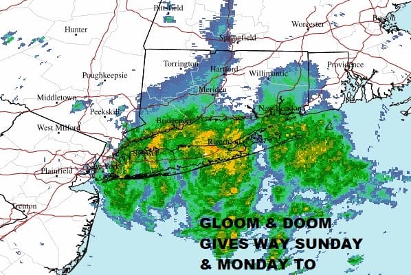
The radar loops clearly show the problem with downpours moving from south to north. Bands of heavy downpours are separated in between by light rain or drizzle. Again this will play itself out and then tonight the rains will be done and skies should partially clear by morning. Humidity levels will drop off as dry ai comes down on northerly winds. Sunday morning lows will be in the upper 50s to near 60.
WEATHER RADAR


On to Sunday where we should see partly sunny skies, a pleasant but relatively cool day. Highs will reach the mid 70s but it will be closer to 70 along the shore. No rain will occur and 4th of July festivities can proceed with no weather issues.

Monday temperatures will push a little higher as will the humidity. Skies should be no worse than partly sunny. An ocean wind will keep temperatures in the mid 70s to around 80 with readings closer to 70 again at the beaches. Tuesday turns very warm and humid with sunshine taking highs to the mid to upper 80s inland and in the 70s to near 80 at the beaches.

Wednesday brings a low across the Lower Great Lakes. This will trigger scattered late day thunderstorms or at least the chance for storms. The day itself will be very warm and humid with partly sunny skies and highs again in the mid to upper 80s. To the south the remnants of Elsa will be moving through the Southeast US and the question for Thursday will be whether that moisture gets absorbed by the approaching cold front and pulled northward meaning more downpours and thunderstorms. This is going to depend on what happens to Elsa in the coming days as it struggles with wind shear, and other issues. For now we will sit back and let that part of the forecast problem play out between now and Monday and the we can better determine what if any impact Elsa will have here later next week.
BE SURE TO DOWNLOAD THE FREE METEOROLOGIST JOE CIOFFI WEATHER APP &
ANGRY BEN’S FREE WEATHER APP “THE ANGRY WEATHERMAN!

MANY THANKS TO TROPICAL TIDBITS & F5 WEATHER FOR THE USE OF MAPS
Please note that with regards to any severe weather, tropical storms, or hurricanes, should a storm be threatening, please consult your local National Weather Service office or your local government officials about what action you should be taking to protect life and property.