Long Island Long Range Forecast For The Week Ahead July 18-24
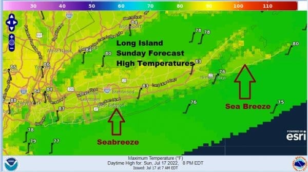
Long Island is going to see the hottest weather of the summer this week. So far 90 degree highs have been elusive except for some areas in Northern Nassau and Northwest Sufflok County. Tuesday Wednesday and Thursday will bring more widespread 90s with only limited sea breezes at the beaches. As for today it will be clouds and some sun and we will watch for the chance of scattered showers or a thunderstorm this evening. Not everyone will see these showers. Later tonight we are going to see another chance for showers into Monday morning. Then late in the day as a cold front arrives, there is a higher chance for showers and thunderstorms. In between look for clouds and some sun with highs into the 80s.
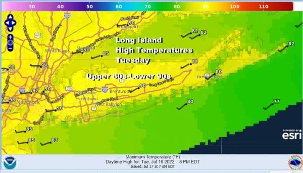
Tuesday begins the stretch of 90s which will last for 3 days. For the most part highs will be in the upper 80s to lower 90s Tuesday and Wednesday. Thursday highs will be a little lower as temperatures reach upper 80s to around 90 degrees except for slightly cooler readings south shore and east end. Late Thursday we look for the chance of thunderstorms as another cold front moves through. This will will be followed by slightly cooler and slightly less humid conditions for Friday and next weekend. As far as rainfall is concerned, due to the scattered nature of thunderstorms, amounts will be variable from place to place and rainfall this week will be generally on the order of a half to 3/4 of an inch in most places. Thunderstorms could always build up into a severe cell as we saw last Thursday. These cells form quickly and die out just as fast so it is a good idea to keep an eye to the sky when outdoors in case such cells do develop.