
Late Afternoon GFS More Red Flags
The late afternoon GFS model hoisted more red flags. Though the model still shows a significant snowfall it is slowly going further south with the southern feature. The upper air map below is for Friday morning. Now the red flags of the afternoon are subtle but they are there. The problem lies in the northern jet stream indicated by the black arrow. That jet is important. You need to have a delicate balance in the atmosphere. The jet in the north needs to be strong enough to feed in cold air and at the same time it needs to be weak enough to allow the southern part of the jet stream to lift northward.
Late Afternoon GFS More Red Flags GFS Friday Morning
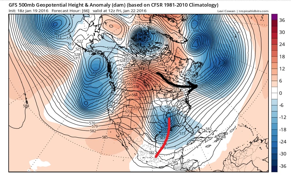
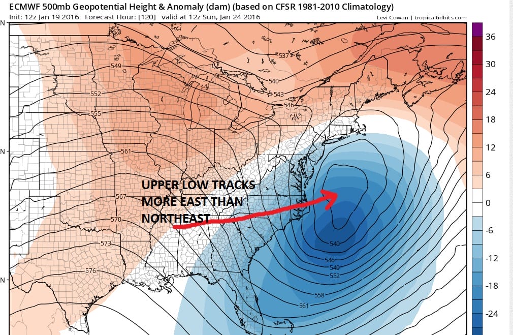
Here in lies the problem. As we have moved through time that jet stream is shown to be stronger which means it winds up being colder in the northeast. All the models show this. The European suggests that the northern jet will be even stronger than the GFS model indicates. Unless that northern jet is weaker than forecast the southern system is going to have a difficult time lifting to the northeast. It is certainly going to try but at some point it is going to take the path of least resistance. That path is more east than north.
Late Afternoon GFS More Red Flags European Friday Morning

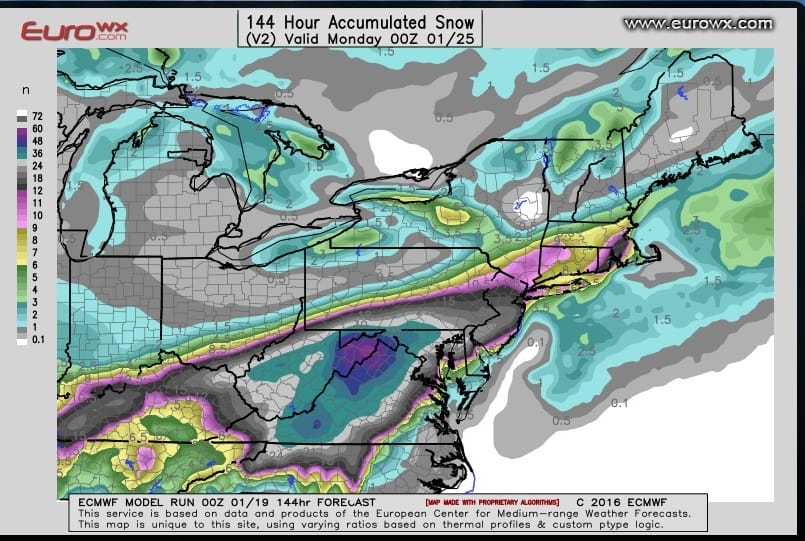
Late Afternoon GFS More Red Flags European Sunday Morning
Now the GFS with its weaker northern jet allows for more room. But here too it is beginning to show that the European may have the better idea. The GFS is a little faster by about 6 hours but it has the upper feature north and west of the European model
Late Afternoon GFS More Red Flags GFS Sunday Morning
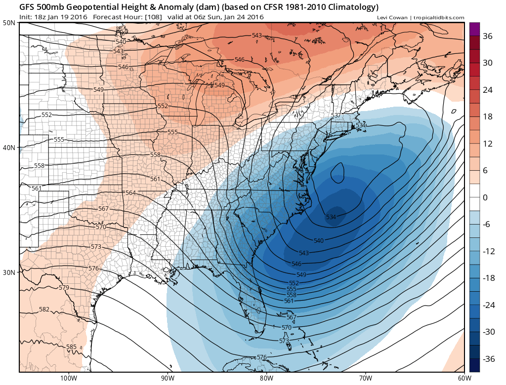
Even here the GFS model is further south east with its upper low position than it was earlier. It literally does produce sizeable snows for the immediate coast from Southeast New England and New York City with the greatest amounts south and east. However north and west of these areas the snow cuts off sharply.

I think if you want to be realistic, you can take the GFS amounts and cut them back by at least 1/3. Look below at the last 3 European snowfall forecast maps courtesy of Eurowx.com and you can see how the southern trend of the European has changed the snowfall forecast.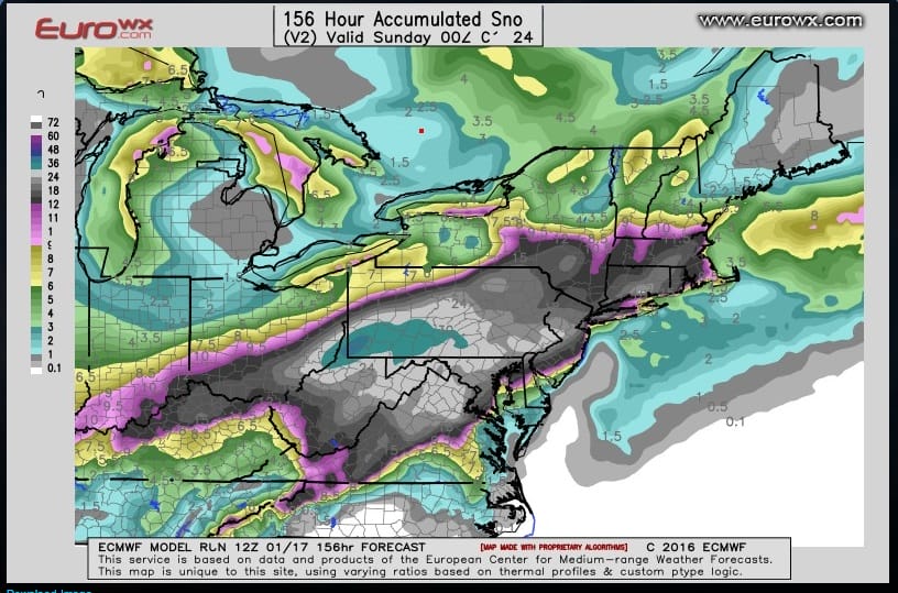
 Tonight’s run will be critical. First off I would look for the European southern trend to continue and the GFS and Canadian slowly coming into line. If the European moves northward for some reason than I would wait at least one more run for confirmation. I keep coming back to this past weekend with the ocean storm that backed westward at the last minute. Granted the situation is different in a lot of ways, however there have been several times in the last 6 weeks where this has happened. The European was the furthest east with the ocean system and the last one to back westward on Sunday. I don’t want to completely close the door on this yet. Obviously there is still plenty of time and the weather system involved is finally coming inland in the west. Let’s see what it does tonight and hopefully we will get some clarity one way or the other.
.
NEW VIDEO ANALYSIS OF AFTERNOON GFS
VIDEO ANALYSIS OF EUROPEAN FROM OVERNIGHT
LATEST EUROPEAN DISCUSSION REGARDING MAJOR STORM THREAT
LATEST GFS DISCUSSION REGARDING MAJOR STORM THREAT
NATIONAL WEATHER SERVICE SNOW FORECASTS
LATEST JOESTRADAMUS ON THE LONG RANGE
Weather App

Winter is here! Don’t be without Meteorologist Joe Cioffi’s weather app. It is a complete weather app to suit your forecast needs. All the weather information you need is right on your phone. Android or I-phone, use it to keep track of all the latest weather information and forecasts. This weather app is also free of advertising so you don’t have to worry about security issues with your device. An accurate forecast and no worries that your device is being compromised.
Use it in conjunction with my website and my facebook and twitterand you have complete weather coverage of all the latest weather and the long range outlook. The website has been redone and upgraded. Its easy to use and everything is archived so you can see how well Joe does or doesn’t do when it comes to forecasts and outlooks.
Just click on the google play button or the apple store button on the sidebar for my app which is onMy Weather Concierge. Download the app for free. Subscribe to my forecasts on an ad free environment for just 99 cents a month.
Get my forecasts in the palm of your hand for less than the cost of a cup of Joe!
![]()
![]()